Fire Tower Trail: Difference between revisions
(convert to new trail form template) |
m (tweaks using form) |
||
| Line 7: | Line 7: | ||
|Trail Use=Hiking, Biking, Geocaching | |Trail Use=Hiking, Biking, Geocaching | ||
|Difficulty Rating=Medium | |Difficulty Rating=Medium | ||
|Hike Time= | |Hike Time=30 min | ||
|Trail Distance= | |Trail Distance=0.7 mi | ||
|Round Trip Distance= | |Round Trip Distance=4.2 mi | ||
|Trail Type=Segment | |Trail Type=Segment | ||
|High Point=2, | |High Point=2,385 Ft | ||
|Low Point=1, | |Low Point=1,893 ft | ||
|Elevation Gain= | |Elevation Gain=0 Ft | ||
|Elevation Loss= | |Elevation Loss=491 Ft | ||
|Elevation Change Direction= | |Elevation Change Direction=North-to-South | ||
|Parking location=36.50882, -82.60955 | |Parking location=36.50882, -82.60955 | ||
|Trailhead location=36. | |Trailhead location=36.51202, -82.61669 | ||
}} | }} | ||
{{Trail Map|Other Trails=River Mountain Road, Lake Road (Bays Mountain Park)}} | {{Trail Map|Other Trails=River Mountain Road, Lake Road (Bays Mountain Park)}} | ||
| Line 73: | Line 73: | ||
== Photos == | == Photos == | ||
{{Park trail gallery|Trail={{PAGENAME}}}} | {{Park trail gallery|Trail={{PAGENAME}}}} | ||
{{Map Marker|Icon Type=Point of interest|Marker Title=Junction with [[Lake Road (Bays Mountain Park)|Lake Road]] | {{Map Marker | ||
{{Map Marker|Icon Type=Overlook|Marker Title=Garden Mountain/Kingsport Lookout Tower|Marker Description=[[Image:BMP_Firetower_Trail_tower.jpg|150px|Fire tower]]|Marker Location=36.51545, -82.6238}} | |Icon Type=Point of interest | ||
|Marker Title=Junction with [[Lake Road (Bays Mountain Park)|Lake Road]] | |||
|Marker Location=36.51202, -82.61669 | |||
}} | |||
{{Map Marker | |||
|Icon Type=Overlook | |||
|Marker Title=Garden Mountain/Kingsport Lookout Tower | |||
|Marker Description=[[Image:BMP_Firetower_Trail_tower.jpg|150px|Fire tower]] | |||
|Marker Location=36.51545, -82.6238 | |||
}} | |||
Revision as of 16:09, 10 November 2019
| Fire Tower Trail (log in to submit report) | |
|---|---|

| |
| Park | Bays Mountain Park |
| Land Owner | City of Kingsport |
| Located | Kingsport, Tennessee |
| Trail Marking | Signs |
| Trail UseThings allowed to do on or near the trail |
|
| FeaturesThings to see on or near the trail |
|
| Difficulty Rating | Medium |
| Hiking TimeTime from car and back. Includes any time hiking to access this trail. | 30 min0.5 Hours <br />0.0313 Days <br /> round trip |
| Distance: | 0.7 mi1.127 km <br /> trailStrict non-repeating trail length / 4.2 mi6.759 km <br /> round tripTypical or shortest length from the car, hike the trail, and return to car |
| Trail Type | Segment |
| Low / High Point | 1,893 ft631 Yards <br />576.986 Meters <br /> / 2,385 Ft795 Yards <br />726.948 Meters <br /> |
| Elev. Gain/LossSee link for details of calculation. Gain/Loss is direction dependent. | 0 Ft0 Meters <br /> / (491 Ft149.657 Meters <br />) – North-to-South |
| Trip ReportsFrom user "hiked it" submissions<br />Recent is within last 90 days | 3 logged hikes (0 recent) |
| NearbyWithin 5 mi<br />Click link to view list | 30 trails / 37.8 mi of trail |
| Parking | 36° 30' 31.75" N, 82° 36' 34.38" W Map |
| Trailhead | 36° 30' 43.27" N, 82° 37' 0.08" W Map |
|
| |
| Show In Google Maps | |
Download KML / Upload new version / KML File Page / Create Profile Chart / gpsvisualizer Map
Trail Overview
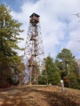
Located in Bays Mountain Park. Second most popular trail (after Lakeside Trail) up to the Garden Mountain/Kingsport firetower for view across Holston Defense, west end of Kingsport, and into Virginia.
How to get there
Take Lakeside Trail clockwise around the reservoir to the Hemlock Trail or Lake Road counterclockwise. The lower trailhead in on Lake Road.
Alternatively, the upper trailhead at the firetower is reached on River Mountain Road from either the antennas or Fegins Gap.
Route Description
The trail heads up Holston River Mountain side of the park to reach the firetower. Although no blazes, the path is well worn, thus apparent.
This trail has connections to River Mountain Road, Chinquapin Trail, and Lake Road
| Miles Up | Fire Tower Trail | Miles Down | Elevation (ft) |
|---|---|---|---|
| 0.0 | Trailhead at Lake Road | 0.7 | 1894 |
| 0.1 | Junction with Chinquapin Trail | 0.6 | |
| 0.7 | Trailhead at River Mountain Road at firetower | 0.0 | 2382 |
For those starting from the parking lot, it is roughly 2 miles taking 60 minutes to reach firetower. Return trip down is faster.
Typical Conditions
Well worn dirt trail with few blowdowns. Please do not cut through the switchbacks.
Regulations
NO BIKES!
Misc. Information
The 60' firetower was constructed by the Civilian Conservation Corps (CCC) in 1937.
Photos
-
View of the firetower