River Mountain Road: Difference between revisions
m (add needs) |
(convert to new trail form template) |
||
| Line 1: | Line 1: | ||
{{Trail | |||
|Park=Bays Mountain Park | |||
|City=Kingsport | |||
|Land Owner=City of Kingsport | |||
|Trail Marking=Signs | |||
|Trail Use=Hiking, Biking, Geocaching | |||
|Difficulty Rating=Hard | |||
|Hike Time=1.5 hrs | |||
|Trail Distance=1.716 mi | |||
|Round Trip Distance=6.8 mi | |||
|Trail Type=Segment | |||
|High Point=2,078 Ft | |||
|Low Point=1,608 ft | |||
|Elevation Gain=386 Ft | |||
|Elevation Loss=461 Ft | |||
|Elevation Change Direction=East-to-West | |||
|Parking location=36.50882, -82.60955 | |||
|Trailhead location=36.49764, -82.6433 | |||
}} | |||
{{Trail Map|Other Trails=Back Hollow Road, Indian Pipes Trail, Lake Road (Bays Mountain Park)}} | |||
__TOC__ | |||
== Trail Overview == | == Trail Overview == | ||
<!-- Enter a overview of the trail. What attracts you to this trail, points of interest, types of flowers, lakes, and peaks that you see along the way. --> | <!-- Enter a overview of the trail. What attracts you to this trail, points of interest, types of flowers, lakes, and peaks that you see along the way. --> | ||
| Line 94: | Line 74: | ||
<!-- Typical conditions throughout the year of what to expect on the trail. Rocky, muddy, sandy, flowers, lots of downed trees? --> | <!-- Typical conditions throughout the year of what to expect on the trail. Rocky, muddy, sandy, flowers, lots of downed trees? --> | ||
Being another one of the restricted access roads it tends to be fairly flat and wide. In wetter months the tracks can be rutted and muddy. On the steep descent down the ridge, it is fairly rocky with large flat boulders to maneuver around | Being another one of the restricted access roads it tends to be fairly flat and wide. In wetter months the tracks can be rutted and muddy. On the steep descent down the ridge, it is fairly rocky with large flat boulders to maneuver around | ||
== Photos == | == Photos == | ||
{{Park trail gallery|Trail={{PAGENAME}}}} | |||
{{Map Marker|Icon Type=Overlook|Marker Title=1937 CCC Built Fire Tower|Marker Description= |Marker Location=36.515470,-82.624164}} | |||
{{Map Marker|Icon Type=Trail sign|Marker Title=[[Indian Pipes Trail]]|Marker Description= |Marker Location=36.513590,-82.627627}} | |||
{{Map Marker|Icon Type=Point of interest|Marker Title=[[Azalea|Azalea Trail]]|Marker Description= |Marker Location=36.526163,-82.587782}} | |||
{{Map Marker|Icon Type=Comm tower|Marker Title= |Marker Description= |Marker Location=36.524918,-82.592413}} | |||
{{Map Marker|Icon Type=Comm tower|Marker Title= |Marker Description= |Marker Location=36.523862,-82.596116}} | |||
{{Map Marker|Icon Type=Point of interest|Marker Title=Crossroads|Marker Description=[[Back Hollow Road|Back Hollow Road]] and [[Lake Road(Bays Mountain Park)|Lake Road]]<br>At Feagin's Gap|Marker Location=36.506548,-82.631278}} | |||
[[ | |||
Revision as of 15:54, 10 November 2019
| River Mountain Road (log in to submit report) | |
|---|---|
| Park | Bays Mountain Park |
| Land Owner | City of Kingsport |
| Located | Kingsport, Tennessee |
| Trail Marking | Signs |
| Trail UseThings allowed to do on or near the trail |
|
| FeaturesThings to see on or near the trail |
|
| Difficulty Rating | Hard |
| Hiking TimeTime from car and back. Includes any time hiking to access this trail. | 1.5 hrs0.0938 Days <br />90 Min <br /> round trip |
| Distance: | 1.716 mi2.762 km <br /> trailStrict non-repeating trail length / 6.8 mi10.944 km <br /> round tripTypical or shortest length from the car, hike the trail, and return to car |
| Trail Type | Segment |
| Low / High Point | 1,608 ft536 Yards <br />490.118 Meters <br /> / 2,078 Ft692.667 Yards <br />633.374 Meters <br /> |
| Elev. Gain/LossSee link for details of calculation. Gain/Loss is direction dependent. | 386 Ft117.653 Meters <br /> / (461 Ft140.513 Meters <br />) – East-to-West |
| Trip ReportsFrom user "hiked it" submissions<br />Recent is within last 90 days | 4 logged hikes (0 recent) |
| NearbyWithin 5 mi<br />Click link to view list | 30 trails / 36.8 mi of trail |
| Parking | 36° 30' 31.75" N, 82° 36' 34.38" W Map |
| Trailhead | 36° 29' 51.50" N, 82° 38' 35.88" W Map |
|
| |
| Show In Google Maps | |
Download KML / Upload new version / KML File Page / Create Profile Chart / gpsvisualizer Map
Trail Overview
Located in Bays Mountain Park. Another restricted access road for nice group hikes up to the ridge offering views of Holston Defense and access to the north ridge fire tower.
How to get there
This gravel road is not directly accessible from the main parking lot, but must be reached through other routes. Typical access trails could be Azalea Trail, Bays Mountain Road, or Lake Road.
Route Description
From the upper end of Trail, River Mountain Road is fairly flat as it follows the north ridge. At the fire tower, it connects with Fire Tower Trail. After passing the junction of Indian Pipes Trail, the road descends off of the ridge passing Bear Run Trail to the crossroads at Feagins Gap with Lake Road and Back Hollow Road.
| Miles | River Mountain Road | Miles | Elevation (ft) |
|---|---|---|---|
| 0.0 | Antennas point on mountain | 3.2 | 2250 |
| 1.5 | Fence line with BAE property | 1.7 | |
| 2.4 | Firetower | 0.8 | 2382 |
| 2.7 | Junction with Indian Pipes Trail | 0.5 | 2352 |
| 3.0 | Junction with Bear Run Trail | 0.2 | |
| 3.2 | Feagins Gap | 0.0 | 1920 |
Typical Conditions
Being another one of the restricted access roads it tends to be fairly flat and wide. In wetter months the tracks can be rutted and muddy. On the steep descent down the ridge, it is fairly rocky with large flat boulders to maneuver around
Photos
-
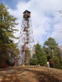
View of the firetower
