Peg Leg Mine: Difference between revisions
(→Misc. Information: add history from pamphlet) |
m (add needs) |
||
| Line 1: | Line 1: | ||
<!-- The following few lines create the "Infobox" table template. Please scroll down to edit the main content of the article. --> | <!-- The following few lines create the "Infobox" table template. Please scroll down to edit the main content of the article. | ||
{{Infobox Trail | |||
-->{{Infobox Trail | |||
| Image Name = Roan Peg Leg mine entrance.jpg | | Image Name = Roan Peg Leg mine entrance.jpg | ||
| Park = Roan Mountain State Park | | Park = Roan Mountain State Park | ||
| Line 18: | Line 19: | ||
| Trailhead coords = 36.176330,-82.079002 | | Trailhead coords = 36.176330,-82.079002 | ||
| Medical = Elizabethton, TN | | Medical = Elizabethton, TN | ||
}} | }}<!-- | ||
<!-- End Infobox template table | |||
End Infobox template table | |||
<!-- | -->{{Trail page needs | ||
| Hide needs = Yes | |||
| KML = | |||
| Updated KML = | |||
| Detail route description = | |||
| Photos = | |||
| Winter photos = | |||
| Remove prefix = | |||
| Update infobox = | |||
| Infobox data update = | |||
| Trail pins = | |||
| Other = | |||
| Comment = Looks good | |||
| Date reviewed = 11/1/2015 | |||
}}<!-- | |||
Start of Main Page --> | |||
== Trail Overview == | == Trail Overview == | ||
<!-- Enter a overview of the trail. What attracts you to this trail, points of interest, types of flowers, lakes, and peaks that you see along the way. --> | <!-- Enter a overview of the trail. What attracts you to this trail, points of interest, types of flowers, lakes, and peaks that you see along the way. --> | ||
Revision as of 08:39, 1 November 2015
| |||||||||||||||||||||||||||||||||||||||||||||

Trail Overview
This is part of the Roan Mountain State Park trail system
How to get there
From the visitor center walk between the water wheel building and the bathrooms. Head left and go under the waterwheel flume to begin the hike.
Route Description
Short trail beginning at the visitor center.
| Feet Out | Peg Leg Mine | Feet Back | Elevation (ft) |
|---|---|---|---|
| 0 | Trail head at Visitor's Center | 1,596 | 2,714 |
| 198 | Unknown split, continue right for trail | 1,398 | 2,697 |
| 1,015 | Viewing platform | 581 | 2,850 |
| 1,596 | Peg Leg Mine | 0 | 2,909 |
Typical Conditions
Being a TN state park, the dirt and gravel trails are kept in good condition. Some of the trail sections are steep, thus can be slippery after a rain.
Misc. Information
General John T. Wilder purchased this land as part of a 7,000 acre purchase for $25.15 an acre in 1870. One of the mines he started became known as the Peg Leg Mine. The mine was mined for iron ore. The ore was sent to a smelter across the Doe River. The water wheel, similar to the one near the visitor's center, was used to lift and drop a 500-lb hammer and to crush the ore. The ore would then be loaded on to rail cars and sent to Cranberry, North Carolina for further processing before making its way to Ohio and Pennsylvania to a steel mill.
Maps
Photos
-
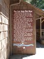
History of the mine
-
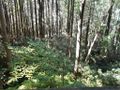
View from the platform
-
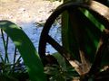
Non-meshing gear of water wheel


