Ridge Top (Roan Mountain State Park): Difference between revisions
Jump to navigation
Jump to search
(Update sections based on recent hike) |
(Add photos) |
||
| Line 2: | Line 2: | ||
-->{{Infobox Trail | -->{{Infobox Trail | ||
| Image Name = | | Image Name = RMSP Ridge Top Trail.jpg | ||
| Park = Roan Mountain State Park | | Park = Roan Mountain State Park | ||
| City = Roan Mountain | | City = Roan Mountain | ||
| Line 72: | Line 72: | ||
http://tehcc.org/clubwiki/kml/RMSP_Ridge_Top.kml"> | http://tehcc.org/clubwiki/kml/RMSP_Ridge_Top.kml"> | ||
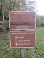
36.167866,-82.096965~Parking~ ~MarkerA.png | 36.167866,-82.096965~Parking~[[Image:Blue 2 Trail Head.jpg|150px|Trail head sign]]~MarkerA.png | ||
36.167498,-82.097859~Old foundation~ ~MarkerV.png | 36.167498,-82.097859~Old foundation~ ~MarkerV.png | ||
36.167416,-82.098804~Trail head with [[Blue 2]]~Ridge Top to the left, Blue 2 right~MarkerT.png | 36.167416,-82.098804~Trail head with [[Blue 2]]~Ridge Top to the left, Blue 2 right~MarkerT.png | ||
| Line 82: | Line 82: | ||
<!-- Place any pictures from this trail below. Ideally we would have a picture of the trailhead to help people know when they found it --> | <!-- Place any pictures from this trail below. Ideally we would have a picture of the trailhead to help people know when they found it --> | ||
<!-- Add a picture by typing Image:imagename.extension --> | <!-- Add a picture by typing Image:imagename.extension --> | ||
Image: | Image:Blue 2 Trail Head.jpg|Trail head sign | ||
<!-- Do not remove the end gallery code.--> | <!-- Do not remove the end gallery code.--> | ||
</gallery> | </gallery> | ||
Revision as of 22:17, 25 October 2015
| |||||||||||||||||||||||||||||||||||||||||||||

Trail Overview
This is part of the Roan Mountain State Park trail system and along with Blue 2 constitutes the Mountain Bike Trails of Roan Mountain State Park
How to get there
From Johnson City (I-26 Exit 24):
- Take TN67/US321 over to Elizabethton (about eight miles).
- Turn right/south at traffic light for TN37/US19E/US321 and travel for 17 miles.
- Turn right/south for TN143 for five miles to park visitors center.
- Trailheads are in several places around the park.
GPS address is 1015 Hwy 143 Roan Mountain, TN 37687.
Route Description
A short alternate option of riding around the mountain bike trails.
Accessible from this trail is Blue 2.
Typical Conditions
The trails are fairly well maintained and blazed fairly clearly with the exception of the Ridge Top connector. As I now recall, it may have been blazed blue as well.
Maps
Ridge Top is shown in yellow. Blue 2 shown in its blaze color light blue (similar to waterways on map). Blue 2 shown in its blaze color light blue (similar to waterways on map) for reference.
Photos
-
Trail head sign
