Forest Road: Difference between revisions
(→Maps: little wider) |
m (add needs) |
||
| Line 1: | Line 1: | ||
<!-- The following few lines create the "Infobox" table template. Please scroll down to edit the main content of the article. --> | <!-- The following few lines create the "Infobox" table template. Please scroll down to edit the main content of the article. | ||
{{Infobox Trail | |||
-->{{Infobox Trail | |||
| Image Name = Roan Forest Road Purple Blaze.jpg | | Image Name = Roan Forest Road Purple Blaze.jpg | ||
| Park = Roan Mountain State Park | | Park = Roan Mountain State Park | ||
| Line 11: | Line 12: | ||
| Round Trip Distance = 6.58 Mi | | Round Trip Distance = 6.58 Mi | ||
| Trail Distance = 3.29 Mi | | Trail Distance = 3.29 Mi | ||
| Trail Type = | | Trail Type = In-and-Out | ||
| Elevation Gain = 1,520 Ft | | Elevation Gain = 1,520 Ft | ||
| Elevation Loss = -1,260 Ft | | Elevation Loss = -1,260 Ft | ||
| Line 18: | Line 19: | ||
| Trailhead coords = 36.176541,-82.079402 | | Trailhead coords = 36.176541,-82.079402 | ||
| Medical = Elizabethton, TN | | Medical = Elizabethton, TN | ||
}} | }}<!-- | ||
<!-- End Infobox template table--> | |||
<!-- Start of Main Page --> | End Infobox template table | ||
-->{{Trail page needs | |||
| Hide needs = Yes | |||
| KML = | |||
| Updated KML = | |||
| Detail route description = | |||
| Photos = | |||
| Winter photos = | |||
| Remove prefix = | |||
| Update infobox = | |||
| Infobox data update = | |||
| Trail pins = | |||
| Other = | |||
| Comment = Page looks good | |||
| Date reviewed = 10/24/2015 | |||
}}<!-- | |||
Start of Main Page --> | |||
== Trail Overview == | == Trail Overview == | ||
<!-- Enter a overview of the trail. What attracts you to this trail, points of interest, types of flowers, lakes, and peaks that you see along the way. --> | <!-- Enter a overview of the trail. What attracts you to this trail, points of interest, types of flowers, lakes, and peaks that you see along the way. --> | ||
Revision as of 12:51, 24 October 2015
| |||||||||||||||||||||||||||||||||||||||||||||

Trail Overview
The longest trail within the Roan Mountain State Park trail system. It largely follows 143 (including all of its road noise) connecting the Visitor Center with the Conference Center, Cabins, and Campground. The 1.65 mi2.655 km <br /> hike of Raven Rock is accessed from this trail.
How to get there
The northern trail head begins across the street from the Visitor Center marked as part of the Boundary Trail System.
Route Description
Trail begins at the Visitor Center and heads south then west until turning south again to cross 143. Afterwards it continues south behind the cabins, and ranger residence until it terminates at the Campground entrance on 143.
| Miles Out | Forest Road | Miles Back | Elevation (ft) |
|---|---|---|---|
| 0.0 | Trail head at Visitor's Center | 3.27 | 2,677 |
| 0.3 | Difficult to pass blow down | 2.97 | 2,806 |
| 1.17 | Intersection with Chestnut Ridge Trail | 2.1 | 2,902 |
| 1.32 | Cross TN 143 and Doe River | 1.95 | 2,818 |
| 1.8 | Intersection with Turkey Trot Trail Trail high point |
1.47 | 3,133 |
| 2.14 | Cabin area access Mystery Mountain Trail Monster |
1.13 | 2,978 |
| 2.36 | Tom Birchfield Rd access | 0.91 | 2,839 |
| 2.47 | Large boulders | 0.8 | 2,946 |
| 2.68 | Conference Center access | 0.59 | 3,055 |
| 2.76 | Raven Rock Trail access | 0.51 | 3,039 |
| 2.92 | Park offices access | 0.35 | 3,055 |
| 3.15 | Raven Rock Trail Access | 0.12 | 2,677 |
| 3.27 | Trail head at TN143 near campground | 0.0 | 2,940 |
Accessible from this trail is Chestnut Ridge, Turkey Trot, and Raven Rock.
Typical Conditions
The northern section can be very rocky and rugged at parts. Trail is well blazed and most trail splits are clearly marked or a trail blaze can be seen down the proper trail to take.
Misc. Information
Maps
Forest Road Trail is shown below in its blaze color purple.
Photos
-
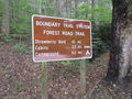
Trail head at Visitor's Center
-
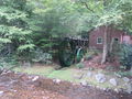
Water wheel at trail head
-

Mystery Mountain Trail Monster


