|
|
| Line 2: |
Line 2: |
| {{Infobox Trail | | {{Infobox Trail |
| | Image Name = BMP Azalea Trail.JPG | | | Image Name = BMP Azalea Trail.JPG |
| | | Trail Number = |
| | Park = Bays Mountain Park | | | Park = Bays Mountain Park |
| | City = Kingsport | | | City = Kingsport |
| Line 9: |
Line 10: |
| | Difficulty Rating = Moderate | | | Difficulty Rating = Moderate |
| | Hike Time = 30 Min | | | Hike Time = 30 Min |
| | Distance = 1.4 Mi | | | Round Trip Distance = 2.78 Mi |
| | Elevation Gain = 360 Ft | | | Trail Distance = 1.39 Mi |
| | Elevation Loss = | | | Trail Type = In-and-Out |
| | High Point = 2,330 Ft | | | Elevation Gain = 616 Ft |
| | Latitude = 36.49487 | | | Elevation Loss = -190 Ft |
| | Longitude = -82.60517 | | | High Point = 2,315 Ft |
| | | Parking coords = 36.508821,-82.609545 |
| | | Trailhead coords = 36.512629,-82.605122 |
| | Medical = Kingsport, TN | | | Medical = Kingsport, TN |
| }} | | }} |
| <!-- End Infobox template table--> | | <!-- End Infobox template table--> |
|
| |
| <!-- Start of Main Page --> | | <!-- Start of Main Page --> |
|
| |
| == Trail Overview == | | == Trail Overview == |
| <!-- Enter a overview of the trail. What attracts you to this trail, points of interest, types of flowers, lakes, and peaks that you see along the way. --> | | <!-- Enter a overview of the trail. What attracts you to this trail, points of interest, types of flowers, lakes, and peaks that you see along the way. --> |
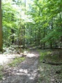
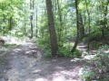
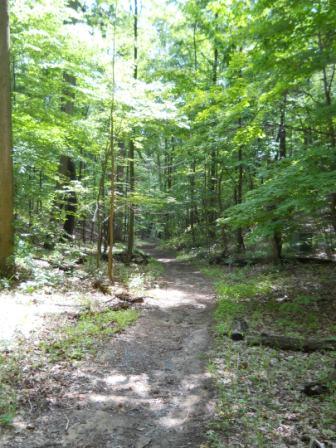
| Located in [[Bays Mountain Park]]. Run or ride up to the Antennas via a trail straight up the hollow. "Azalea" Trail is a misnomer as there are no azaleas along this path, but a forest of maples, tulip populars, ferns, and other hardwoods to enjoy. | | Located in [[Bays Mountain Park]]. Run or ride up to the Antennas via a trail straight up the hollow. "Azalea" Trail is a misnomer as there are no azaleas along this path, but a forest of maples, tulip poplars, ferns, and other hardwoods to enjoy. |
|
| |
|
| == How to get there == | | == How to get there == |
| Line 41: |
Line 42: |
| |- | | |- |
| |0.0 | | |0.0 |
| |Trailhead at [[BMP Lake Road|Lake Road]] | | |Trailhead at [[Lake Road|Lake Road]] |
| |1.4 | | |1.4 |
| |1860 | | |1860 |
| |- | | |- |
| |1.0 | | |1.0 |
| |Junction with [[BMP Big Oak Trail|Big Oak Trail]] | | |Junction with [[Big Oak Trail|Big Oak Trail]] |
| |0.4 | | |0.4 |
| | | | | |
| |- | | |- |
| |1.4 | | |1.4 |
| |Trailhead at [[BMP Bays Mountain Road|Bays Mountain Road]] | | |Trailhead at [[Bays Mountain Road|Bays Mountain Road]] |
| |0.0 | | |0.0 |
| |2250 | | |2250 |
| Line 63: |
Line 64: |
| <!-- Please list any Fees, Permits, Regulations, etc. that may be required on this trail.--> | | <!-- Please list any Fees, Permits, Regulations, etc. that may be required on this trail.--> |
| Do not mess with the electrical boxes along the trail - they are live! | | Do not mess with the electrical boxes along the trail - they are live! |
|
| |
| == After the Hike ==
| |
| <!-- Other things to check out while you're in the area. Restaurants, attractions, monuments, etc... -->
| |
| Check out the animal habitats - say "Hi" to Merlin.
| |
|
| |
|
| == Misc. Information == | | == Misc. Information == |
| Line 78: |
Line 75: |
|
| |
|
| 36.52726, -82.5861~Antennas, elevation 2250'~[[Image:BMP Antennas.JPG|150px]]<br>[[Image:BMP View of downtown Kingsport.JPG|Overlook of Kingsport downtown|150px]]~MarkerE.png | | 36.52726, -82.5861~Antennas, elevation 2250'~[[Image:BMP Antennas.JPG|150px]]<br>[[Image:BMP View of downtown Kingsport.JPG|Overlook of Kingsport downtown|150px]]~MarkerE.png |
| 36.51262,-82.60520~Trailhead at [[BMP Lake Road|Lake Road]]~[[Image:BMP Azalea Trail sign.JPG|50px]]~MarkerG.png | | 36.51262,-82.60520~Trailhead at [[Lake Road|Lake Road]]~[[Image:BMP Azalea Trail sign.JPG|50px]]~MarkerG.png |
| 36.52614,-82.58772~Trailhead at [[BMP Bays Mountain Road|Bays Mountain Road]]~[[Image:BMP Azalea Trail sign at BMR.JPG|50px]]~MarkerG.png | | 36.52614,-82.58772~Trailhead at [[Bays Mountain Road|Bays Mountain Road]]~[[Image:BMP Azalea Trail sign at BMR.JPG|50px]]~MarkerG.png |
| 36.52221,-82.59283~Intersection at [[BMP Big Oak Trail|Big Oak Trail]]~[[Image:BMP Split at Azalea and Big Oak Trails.JPG|100px]]~MarkerG.png | | 36.52221,-82.59283~Intersection at [[Big Oak Trail|Big Oak Trail]]~[[Image:BMP Split at Azalea and Big Oak Trails.JPG|100px]]~MarkerG.png |
| </display_map> | | </display_map> |
|
| |
|
| Line 101: |
Line 98: |
| <!-- Finally add the trail to any Categories it should belong to. --> | | <!-- Finally add the trail to any Categories it should belong to. --> |
| [[Category:Tennessee]] [[Category:Kingsport]] [[Category:Bays Mountain Park]] [[Category:Medium]] [[Category:Hiking]] [[Category:Biking]] [[Category:Dog Friendly]] | | [[Category:Tennessee]] [[Category:Kingsport]] [[Category:Bays Mountain Park]] [[Category:Medium]] [[Category:Hiking]] [[Category:Biking]] [[Category:Dog Friendly]] |
| | {{#set: |
| | |Trail page needs=Detail route description;Update infobox;Trail pins;Update mileage;Update 1|+sep=; |
| | }} |
|
|
|
|
|
| Trail Name
|
Azalea
|
| Park
|
Bays Mountain Park
|
| Nearest City
|
Kingsport
|
| State
|
Tennessee
|
| Trail Marking
|
Junction Signs
|
| Trail Use/Features
|
  
|
| Difficulty Rating
|
Moderate
|
| Hiking Time
|
30 Min0.5 Hours <br />0.0313 Days <br />
|
Distance:
round-trip/trail only
|
2.78 Mi4.474 km <br /> / 1.39 Mi2.237 km <br />
|
| Trail Type
|
In-and-Out
|
| Climb/Descent Elevation
|
616 Ft187.757 Meters <br /> / -190 Ft-57.912 Meters <br />
|
| High Point
|
2,315 Ft771.667 Yards <br />705.612 Meters <br />
|
| Parking
|
36° 30' 31.76" N, 82° 36' 34.36" W
|
| Trailhead
|
36° 30' 45.46" N, 82° 36' 18.44" W
|
| Nearest Medical
|
Kingsport, TN
|
| Trip Reports
|
Click Here
|
|
|
Loading map... {"type":"ROADMAP","minzoom":false,"maxzoom":false,"types":["ROADMAP","SATELLITE","HYBRID","TERRAIN"],"mappingservice":"googlemaps3","width":"270px","height":"180px","centre":false,"title":"","label":"","icon":"","lines":[],"polygons":[],"circles":[],"rectangles":[],"copycoords":false,"static":false,"visitedicon":"","wmsoverlay":false,"zoom":8,"layers":[],"controls":["zoom"],"zoomstyle":"DEFAULT","typestyle":"DEFAULT","autoinfowindows":false,"resizable":false,"kmlrezoom":false,"poi":true,"cluster":false,"clustergridsize":60,"clustermaxzoom":20,"clusterzoomonclick":true,"clusteraveragecenter":true,"clusterminsize":2,"imageoverlays":[],"kml":[],"gkml":[],"searchmarkers":"","fullscreen":false,"scrollwheelzoom":false,"locations":[{"text":"","title":"","link":"","lat":36.5088209999999975252649164758622646331787109375,"lon":-82.609544999999997116901795379817485809326171875,"icon":""}]} |
|
| Show Large Map
|
|
Trail Overview
Located in Bays Mountain Park. Run or ride up to the Antennas via a trail straight up the hollow. "Azalea" Trail is a misnomer as there are no azaleas along this path, but a forest of maples, tulip poplars, ferns, and other hardwoods to enjoy.
How to get there
From the main parking lot, pass through or around the bird and wolf habitats to reach Lake Road. Continue around to marked trailhead.
Route Description
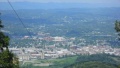
The path runs right up the hollow along side of an intermittent runoff stream. One up on Bays Mountain Road, many folks would continue up to the Antennas for the view of downtown Kingsport.
Typical Conditions
Hard packed and sometimes rutted trail. The runoff stream can flow down the trail during spring or hard rains. Park does a great job of cutting through the blowdowns.
Regulations
Do not mess with the electrical boxes along the trail - they are live!
Misc. Information
Maps
Loading map...
{"type":"TERRAIN","minzoom":false,"maxzoom":false,"types":["ROADMAP","SATELLITE","HYBRID","TERRAIN"],"mappingservice":"googlemaps3","width":"auto","height":"550px","centre":{"text":"","title":"","link":"","lat":36.518000000000000682121026329696178436279296875,"lon":-82.605999999999994543031789362430572509765625,"icon":""},"title":"","label":"","icon":"","lines":[],"polygons":[],"circles":[],"rectangles":[],"copycoords":false,"static":false,"visitedicon":"","wmsoverlay":false,"zoom":14,"layers":[],"controls":["pan","zoom","type","scale","streetview","rotate"],"zoomstyle":"DEFAULT","typestyle":"DEFAULT","autoinfowindows":false,"resizable":false,"kmlrezoom":false,"poi":true,"cluster":false,"clustergridsize":60,"clustermaxzoom":20,"clusterzoomonclick":true,"clusteraveragecenter":true,"clusterminsize":2,"imageoverlays":[],"kml":[],"gkml":["http://tehcc.org/clubwiki/kml/BMP_Azalea_Trail.kml","http://tehcc.org/clubwiki/kml/BMP_bays_mountain_road.kml","http://tehcc.org/clubwiki/kml/BMP_Big_Oak_Trail.kml"],"searchmarkers":"","fullscreen":false,"scrollwheelzoom":false,"locations":[{"text":"\u003Cb\u003E\u003Cdiv class=\"mw-parser-output\"\u003E\u003Cp\u003EAntennas, elevation 2250'\n\u003C/p\u003E\u003C/div\u003E\u003C/b\u003E\u003Cdiv class=\"mw-parser-output\"\u003E\u003Cp\u003E\u003Ca href=\"/wiki/File:BMP_Antennas.JPG\" class=\"image\"\u003E\u003Cimg alt=\"BMP Antennas.JPG\" src=\"/clubwiki/images/thumb/BMP_Antennas.JPG/150px-BMP_Antennas.JPG\" decoding=\"async\" width=\"150\" height=\"261\" srcset=\"/clubwiki/images/thumb/BMP_Antennas.JPG/225px-BMP_Antennas.JPG 1.5x, /clubwiki/images/BMP_Antennas.JPG 2x\" data-file-width=\"257\" data-file-height=\"448\" /\u003E\u003C/a\u003E\u003Cbr /\u003E\u003Ca href=\"/wiki/File:BMP_View_of_downtown_Kingsport.JPG\" class=\"image\" title=\"Overlook of Kingsport downtown\"\u003E\u003Cimg alt=\"Overlook of Kingsport downtown\" src=\"/clubwiki/images/thumb/BMP_View_of_downtown_Kingsport.JPG/150px-BMP_View_of_downtown_Kingsport.JPG\" decoding=\"async\" width=\"150\" height=\"84\" srcset=\"/clubwiki/images/thumb/BMP_View_of_downtown_Kingsport.JPG/225px-BMP_View_of_downtown_Kingsport.JPG 1.5x, /clubwiki/images/thumb/BMP_View_of_downtown_Kingsport.JPG/300px-BMP_View_of_downtown_Kingsport.JPG 2x\" data-file-width=\"448\" data-file-height=\"252\" /\u003E\u003C/a\u003E\n\u003C/p\u003E\u003C/div\u003E","title":"Antennas, elevation 2250'\n","link":"","lat":36.5272599999999982856024871580302715301513671875,"lon":-82.5861000000000018417267710901796817779541015625,"icon":"/clubwiki/images/MarkerE.png"},{"text":"\u003Cb\u003E\u003Cdiv class=\"mw-parser-output\"\u003E\u003Cp\u003ETrailhead at \u003Ca href=\"/wiki/Lake_Road\" title=\"Lake Road\"\u003ELake Road\u003C/a\u003E\n\u003C/p\u003E\u003C/div\u003E\u003C/b\u003E\u003Cdiv class=\"mw-parser-output\"\u003E\u003Cp\u003E\u003Ca href=\"/wiki/File:BMP_Azalea_Trail_sign.JPG\" class=\"image\"\u003E\u003Cimg alt=\"BMP Azalea Trail sign.JPG\" src=\"/clubwiki/images/thumb/BMP_Azalea_Trail_sign.JPG/50px-BMP_Azalea_Trail_sign.JPG\" decoding=\"async\" width=\"50\" height=\"160\" srcset=\"/clubwiki/images/thumb/BMP_Azalea_Trail_sign.JPG/75px-BMP_Azalea_Trail_sign.JPG 1.5x, /clubwiki/images/thumb/BMP_Azalea_Trail_sign.JPG/100px-BMP_Azalea_Trail_sign.JPG 2x\" data-file-width=\"140\" data-file-height=\"448\" /\u003E\u003C/a\u003E\n\u003C/p\u003E\u003C/div\u003E","title":"Trailhead at Lake Road\n","link":"","lat":36.512619999999998299244907684624195098876953125,"lon":-82.605199999999996407495927996933460235595703125,"icon":"/clubwiki/images/MarkerG.png"},{"text":"\u003Cb\u003E\u003Cdiv class=\"mw-parser-output\"\u003E\u003Cp\u003ETrailhead at \u003Ca href=\"/wiki/Bays_Mountain_Road\" title=\"Bays Mountain Road\"\u003EBays Mountain Road\u003C/a\u003E\n\u003C/p\u003E\u003C/div\u003E\u003C/b\u003E\u003Cdiv class=\"mw-parser-output\"\u003E\u003Cp\u003E\u003Ca href=\"/wiki/File:BMP_Azalea_Trail_sign_at_BMR.JPG\" class=\"image\"\u003E\u003Cimg alt=\"BMP Azalea Trail sign at BMR.JPG\" src=\"/clubwiki/images/thumb/BMP_Azalea_Trail_sign_at_BMR.JPG/50px-BMP_Azalea_Trail_sign_at_BMR.JPG\" decoding=\"async\" width=\"50\" height=\"174\" srcset=\"/clubwiki/images/thumb/BMP_Azalea_Trail_sign_at_BMR.JPG/75px-BMP_Azalea_Trail_sign_at_BMR.JPG 1.5x, /clubwiki/images/thumb/BMP_Azalea_Trail_sign_at_BMR.JPG/100px-BMP_Azalea_Trail_sign_at_BMR.JPG 2x\" data-file-width=\"129\" data-file-height=\"448\" /\u003E\u003C/a\u003E\n\u003C/p\u003E\u003C/div\u003E","title":"Trailhead at Bays Mountain Road\n","link":"","lat":36.52613999999999805368133820593357086181640625,"lon":-82.5877200000000044610715121962130069732666015625,"icon":"/clubwiki/images/MarkerG.png"},{"text":"\u003Cb\u003E\u003Cdiv class=\"mw-parser-output\"\u003E\u003Cp\u003EIntersection at \u003Ca href=\"/wiki/Big_Oak_Trail\" title=\"Big Oak Trail\"\u003EBig Oak Trail\u003C/a\u003E\n\u003C/p\u003E\u003C/div\u003E\u003C/b\u003E\u003Cdiv class=\"mw-parser-output\"\u003E\u003Cp\u003E\u003Ca href=\"/wiki/File:BMP_Split_at_Azalea_and_Big_Oak_Trails.JPG\" class=\"image\"\u003E\u003Cimg alt=\"BMP Split at Azalea and Big Oak Trails.JPG\" src=\"/clubwiki/images/thumb/BMP_Split_at_Azalea_and_Big_Oak_Trails.JPG/100px-BMP_Split_at_Azalea_and_Big_Oak_Trails.JPG\" decoding=\"async\" width=\"100\" height=\"75\" srcset=\"/clubwiki/images/thumb/BMP_Split_at_Azalea_and_Big_Oak_Trails.JPG/150px-BMP_Split_at_Azalea_and_Big_Oak_Trails.JPG 1.5x, /clubwiki/images/thumb/BMP_Split_at_Azalea_and_Big_Oak_Trails.JPG/200px-BMP_Split_at_Azalea_and_Big_Oak_Trails.JPG 2x\" data-file-width=\"448\" data-file-height=\"336\" /\u003E\u003C/a\u003E\n\u003C/p\u003E\u003C/div\u003E","title":"Intersection at Big Oak Trail\n","link":"","lat":36.522210000000001173248165287077426910400390625,"lon":-82.5928300000000064073901739902794361114501953125,"icon":"/clubwiki/images/MarkerG.png"}]}
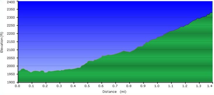
- The following elevation profile proceeds from Lake Road to Bays Mountain Road.
Photos
Overlook of Kingsport downtown