Forest Road: Difference between revisions
(→Route Description: fix route description) |
(→Maps: use new road and trail pins) |
||
| Line 124: | Line 124: | ||
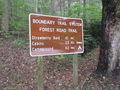
36.176045,-82.079734~Trail head~[[Image:Roan Forest Road Trail Head at Visitors Center.jpg|150px|Trail head at Visitor's Center]]~MarkerG.png | 36.176045,-82.079734~Trail head~[[Image:Roan Forest Road Trail Head at Visitors Center.jpg|150px|Trail head at Visitor's Center]]~MarkerG.png | ||
36.173041,-82.081611~Difficult to pass blow down~ ~MarkerG.png | 36.173041,-82.081611~Difficult to pass blow down~ ~MarkerG.png | ||
36.173185,-82.090658~Intersection with Chestnut Ridge~ ~ | 36.173185,-82.090658~Intersection with Chestnut Ridge~ ~MarkerT.png | ||
36.172867,-82.092025~TN143 Crossing~ ~ | 36.172867,-82.092025~TN143 Crossing~ ~MarkerU.png | ||
36.17241,-82.092043~River swim spot~Trail splits, trail continues left/north, unknown other direction~MarkerL.png | 36.17241,-82.092043~River swim spot~Trail splits, trail continues left/north, unknown other direction~MarkerL.png | ||
36.172241,-82.091629~Trail split~unknown white left, Forest Road right~ | 36.172241,-82.091629~Trail split~unknown white left, Forest Road right~MarkerT.png | ||
36.170629,-82.092533~Large rock along trail~ ~MarkerG.png | 36.170629,-82.092533~Large rock along trail~ ~MarkerG.png | ||
36.169924,-82.092525~Connect with Turkey Trot~ ~ | 36.169924,-82.092525~Connect with Turkey Trot~ ~MarkerT.png | ||
36.166645,-82.090959~Connector to rear of cabins~[[Image:Roan Mystery Mountain Trail Monster.jpg|150px|Mystery Mountain Trail Monster]]~MarkerG.png | 36.166645,-82.090959~Connector to rear of cabins~[[Image:Roan Mystery Mountain Trail Monster.jpg|150px|Mystery Mountain Trail Monster]]~MarkerG.png | ||
36.165782,-82.087584~Trail split~Turn right/east to continue, street access to left~ | 36.165782,-82.087584~Trail split~Turn right/east to continue, street access to left~MarkerT.png | ||
36.164984,-82.088515~Large rock~ ~MarkerG.png | 36.164984,-82.088515~Large rock~ ~MarkerG.png | ||
36.163626,-82.091402~Access to conference center~Stay on blazed trail~MarkerG.png | 36.163626,-82.091402~Access to conference center~Stay on blazed trail~MarkerG.png | ||
36.162928,-82.092131~Intersection with Raven Rock Trail~ ~ | 36.162928,-82.092131~Intersection with Raven Rock Trail~ ~MarkerT.png | ||
36.161713,-82.093587~Access to park ranger office~ ~ | 36.161713,-82.093587~Access to park ranger office~ ~MarkerT.png | ||
36.159802,-82.096066~Intersection with Raven Rock Trail~ ~ | 36.159802,-82.096066~Intersection with Raven Rock Trail~ ~MarkerT.png | ||
36.1604,-82.097376~Trail head~ ~MarkerG.png | 36.1604,-82.097376~Trail head~ ~MarkerG.png | ||
</display_map> | </display_map> | ||
Revision as of 10:03, 27 September 2015
| |||||||||||||||||||||||||||||||||||||||||||||

Trail Overview
The longest trail within the Roan Mountain State Park trail system. It largely follows 143 (including all of its road noise) connecting the Visitor Center with the Conference Center, Cabins, and Campground. The 1.65 mi2.655 km <br /> hike of Raven Rock is accessed from this trail.
How to get there
The northern trail head begins across the street from the Visitor Center marked as part of the Boundary Trail System.
Route Description
Trail begins at the Visitor Center and heads south then west until turning south again to cross 143. Afterwards it continues south behind the cabins, and ranger residence until it terminates at the Campground entrance on 143.
| Miles Out | Forest Road | Miles Back | Elevation (ft) |
|---|---|---|---|
| 0.0 | Trail head at Visitor's Center | 3.27 | 2,677 |
| 0.3 | Difficult to pass blow down | 2.97 | 2,806 |
| 1.17 | Intersection with Chestnut Ridge Trail | 2.1 | 2,902 |
| 1.32 | Cross TN 143 and Doe River | 1.95 | 2,818 |
| 1.8 | Intersection with Turkey Trot Trail Trail high point |
1.47 | 3,133 |
| 2.14 | Cabin area access Mystery Mountain Trail Monster |
1.13 | 2,978 |
| 2.36 | Tom Birchfield Rd access | 0.91 | 2,839 |
| 2.47 | Large boulders | 0.8 | 2,946 |
| 2.68 | Conference Center access | 0.59 | 3,055 |
| 2.76 | Raven Rock Trail access | 0.51 | 3,039 |
| 2.92 | Park offices access | 0.35 | 3,055 |
| 3.15 | Raven Rock Trail Access | 0.12 | 2,677 |
| 3.27 | Trail head at TN143 near campground | 0.0 | 2,940 |
Accessible from this trail is Chestnut Ridge, Turkey Trot, and Raven Rock.
Typical Conditions
The northern section can be very rocky and rugged at parts. Trail is well blazed and most trail splits are clearly marked or a trail blaze can be seen down the proper trail to take.
Misc. Information
Maps
Forest Road Trail is shown below in its blaze color purple.
Photos
-
Trail head at Visitor's Center
-
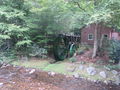
Water wheel at trail head
-
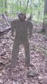
Mystery Mountain Trail Monster


