Peg Leg Mine: Difference between revisions
Jump to navigation
Jump to search
(Add pictures) |
(Add waypoints and route description) |
||
| Line 29: | Line 29: | ||
== How to get there == | == How to get there == | ||
<!-- Please enter detailed instruction on how to find the trail head. --> | <!-- Please enter detailed instruction on how to find the trail head. --> | ||
From the visitor center walk between the water wheel building and the bathrooms. Head left and go under the | From the visitor center walk between the water wheel building and the bathrooms. Head left and go under the waterwheel flume to begin the hike. | ||
== Route Description== | == Route Description== | ||
<!-- Detailed description of the route. Is there any side trails that are worth traveling? --> | <!-- Detailed description of the route. Is there any side trails that are worth traveling? --> | ||
Short trail beginning at the visitor center. | Short trail beginning at the visitor center. | ||
{| class="wikitable" border="1" | |||
|- | |||
!Feet Out | |||
!{{PAGENAME}} | |||
!Feet Back | |||
!Elevation (ft) | |||
|- | |||
|0 | |||
|Trail head at Visitor's Center | |||
|1,596 | |||
|2,714 | |||
|- | |||
|198 | |||
|Unknown split, continue right for trail | |||
|1,398 | |||
|2,697 | |||
|- | |||
|1,015 | |||
|Viewing platform | |||
|581 | |||
|2,850 | |||
|- | |||
|1,596 | |||
|Peg Leg Mine | |||
|0 | |||
|2,909 | |||
|} | |||
== Typical Conditions == | == Typical Conditions == | ||
| Line 45: | Line 73: | ||
<!-- You can place pictures, PDF's, links, or even create a Google map with your waypoints and place it here. --> | <!-- You can place pictures, PDF's, links, or even create a Google map with your waypoints and place it here. --> | ||
<display_map center="36.176544,-82.077725" type="terrain" zoom="16" width="auto" height="550" gkml="http://tehcc.org/clubwiki/kml/RMSP_Peg_Leg_Trail.kml"> | <display_map center="36.176544,-82.077725" type="terrain" zoom="16" width="auto" height="550" gkml="http://tehcc.org/clubwiki/kml/RMSP_Peg_Leg_Trail.kml"> | ||
36.17633,-82.079002~Trail head~ ~MarkerG.png | |||
36.176882,-82.078971~Trail split~Continue right for the trail, unknown trail to the left~MarkerG.png | |||
36.176719,-82.077615~Viewing platform[[Image:Roan Peg Leg view from platform.jpg|150px|View from the platform]]~MarkerE.png | |||
36.176135,-82.076313~Peg leg mine~[[Image:Roan Peg Leg mine entrance.jpg|150px|View from the platform]]~MarkerI.png | |||
</display_map> | </display_map> | ||
| Line 58: | Line 90: | ||
<!-- Finally add the trail to any Categories it should belong to. --> | <!-- Finally add the trail to any Categories it should belong to. --> | ||
[[Category:Tennessee]] [[Category:Medium]] [[Category:Hiking]] [[Category:Dog Friendly | [[Category:Tennessee]] [[Category:Medium]] [[Category:Hiking]] [[Category:Dog Friendly]] | ||
Revision as of 09:34, 26 September 2015
| |||||||||||||||||||||||||||||||||||||||||||||

Trail Overview
This is part of the Roan Mountain State Park trail system
How to get there
From the visitor center walk between the water wheel building and the bathrooms. Head left and go under the waterwheel flume to begin the hike.
Route Description
Short trail beginning at the visitor center.
| Feet Out | Peg Leg Mine | Feet Back | Elevation (ft) |
|---|---|---|---|
| 0 | Trail head at Visitor's Center | 1,596 | 2,714 |
| 198 | Unknown split, continue right for trail | 1,398 | 2,697 |
| 1,015 | Viewing platform | 581 | 2,850 |
| 1,596 | Peg Leg Mine | 0 | 2,909 |
Typical Conditions
Being a TN state park, the dirt and gravel trails are kept in good condition. Some of the trail sections are steep, thus can be slippery after a rain.
Misc. Information
Maps
Photos
-
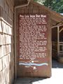
History of the mine
-
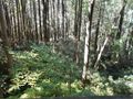
View from the platform
-
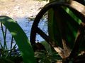
Non-meshing gear of water wheel


