Turkey Trot: Difference between revisions
Jump to navigation
Jump to search
(add kmls) |
(Add pictures) |
||
| Line 1: | Line 1: | ||
<!-- The following few lines create the "Infobox" table template. Please scroll down to edit the main content of the article. --> | <!-- The following few lines create the "Infobox" table template. Please scroll down to edit the main content of the article. --> | ||
{{Infobox Trail | {{Infobox Trail | ||
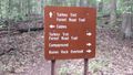
| Image Name = | | Image Name = Roan Turkey Trot sign.jpg | ||
| Park = Roan Mountain State Park | | Park = Roan Mountain State Park | ||
| City = Roan Mountain | | City = Roan Mountain | ||
| Line 23: | Line 23: | ||
== Trail Overview == | == Trail Overview == | ||
<!-- Enter a overview of the trail. What attracts you to this trail, points of interest, types of flowers, lakes, and peaks that you see along the way. --> | <!-- Enter a overview of the trail. What attracts you to this trail, points of interest, types of flowers, lakes, and peaks that you see along the way. --> | ||
This is part of the [[Roan Mountain State Park]] trail system | This is part of the [[Roan Mountain State Park]] trail system and can be used as part of a circuit from the campground or the cabins using one of the many access trails along this and [[Forest Road|Forest Road Trail]]. | ||
== How to get there == | == How to get there == | ||
| Line 56: | Line 56: | ||
<!-- Place any pictures from this trail below. Ideally we would have a picture of the trailhead to help people know when they found it --> | <!-- Place any pictures from this trail below. Ideally we would have a picture of the trailhead to help people know when they found it --> | ||
<!-- Add a picture by typing Image:imagename.extension --> | <!-- Add a picture by typing Image:imagename.extension --> | ||
Image: | Image:Roan Forest Road and Turkey Trot.jpg|Intersection of Forest Road and Turkey Trot Trails | ||
Image:Roan Mystery Mountain Trail Monster.jpg|Mystery Mountain Trail Monster | |||
Image:Roan Turkey Trot Trail.jpg|View of the trail | |||
<!-- Do not remove the end gallery code.--> | <!-- Do not remove the end gallery code.--> | ||
</gallery> | </gallery> | ||
Revision as of 12:46, 20 September 2015
| |||||||||||||||||||||||||||||||||||||||||||||

Trail Overview
This is part of the Roan Mountain State Park trail system and can be used as part of a circuit from the campground or the cabins using one of the many access trails along this and Forest Road Trail.
How to get there
From Johnson City (I-26 Exit 24):
- Take TN67/US321 over to Elizabethton (about eight miles).
- Turn right/south at traffic light for TN37/US19E/US321 and travel for 17 miles.
- Turn right/south for TN143 for five miles to park visitors center.
- Trailheads are in several places around the park.
GPS address is 1015 Hwy 143 Roan Mountain, TN 37687.
Route Description
A spur off of Forest Road Trail.
Typical Conditions
Being a TN state park, the dirt and gravel trails are kept in good condition. Some of the trail sections are steep, thus can be slippery after a rain.
Misc. Information
Maps
Turkey Trot Trail is shown below in its blaze color red.
Photos
-
Intersection of Forest Road and Turkey Trot Trails
-

Mystery Mountain Trail Monster
-
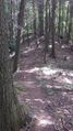
View of the trail


