Overmountain Victory National Historic Trail: Difference between revisions
No edit summary |
(Creating the actual wiki page format versus couple of pictures) |
||
| Line 1: | Line 1: | ||
<!-- The following few lines create the "Infobox" table template. Please scroll down to edit the main content of the article. --> | |||
{{Infobox Trail | |||
| Image Name = OMVT1.jpg | |||
| City = Roan Mountain | |||
| State = Tennessee | |||
| Marking = * | |||
| Trail Use = {{Hike}} | |||
| Difficulty Rating = Easy | |||
| Hike Time = 3-5 | |||
| Distance = 3.6-6.6 | |||
| Elevation Gain = 550-1400 | |||
| High Point = ~4600 | |||
| Latitude = 36.152383 | |||
| Longitude = -82.055733 | |||
| Medical = Elizabethton, TN | |||
}} | |||
<!-- End Infobox template table--> | |||
<!-- Start of Main Page --> | |||
== Trail Overview == | |||
<!-- Enter a overview of the trail. What attracts you to this trail, points of interest, types of flowers, lakes, and peaks that you see along the way. --> | |||
While the Overmountain Victory National Historic Trail stretches 330 miles, there are only a few segments that are not paved highway and open to the public. This page describes the 3.5 mile section located in the Hampton Creek Cove State Natural Area. | |||
== How to get there == | |||
<!-- Please enter detailed instruction on how to find the trail head. --> | |||
From Johnson City, TN | |||
#Head south on Roan Street for 3.5 miles passing under I-26. | |||
#Take left/east onto TN359/Okolona Road and travel 1.4 miles. | |||
#Take right/south onto TN361 over to US19E for nine miles. The road starts as Laurels Road, then Dry Creek Road and finally Gap Creek Road. | |||
#Travel US19E for ten miles to town of Roan Mountain. | |||
#Take right/south onto TN143. | |||
#Cross bridge and then take left/east onto Stratton Street. | |||
#Take right/south onto Old Highway 143/Sawdust Trail to Cloudland Elem School. | |||
#Turn left/east onto Hampton Creek Road and proceed three miles. | |||
#Parking area is on left/east side of road. | |||
== Route Description== | |||
<!-- Detailed description of the route. Is there any side trails that are worth traveling? --> | |||
The Overmountain Trail begins at the parking lot follows the Left Prong creek up Yellow Mountain to intersection with the Appalachian Trail at the gap. The path continues into North Carolina for another 1.5 miles. | |||
== Typical Conditions == | |||
<!-- Typical conditions throughout the year of what to expect on the trail. Rocky, muddy, sandy, flowers, lots of downed trees? --> | |||
==Fees, Permits, etc. == | |||
<!-- Please list any Fees, Permits, Regulations, etc. that may be required on this trail.--> | |||
No permit or fee. The nature area closes at dusk. | |||
== After the Hike == | |||
<!-- Anywhere interesting to stop by since you're in the area!! --> | |||
== Misc. Information == | |||
<!-- Enter any additional information that doesn't fit an any other fields. Does this trail require any permits for overnight? parking? --> | |||
Hampton Creek Cove is a 693-acre natural area. The official TN.gov Hampton Creek Cove [http://www.tn.gov/environment/na/natareas/hampton/ webpage] including [http://www.tn.gov/environment/na/natareas/hampton/hampton.pdf map]. | |||
== Maps == | |||
<googlemap lat="36.14" lon="-82.055733" type="terrain" zoom="14" height="600" scale="yes" icons="http://tehcc.org/clubwiki/kml/marker{label}.png"> | |||
http://tehcc.org/clubwiki/kml/Placeholder_trail.kml | |||
(A) 36.152383,-82.055733 | |||
Parking | |||
</googlemap> | |||
== Photos == | |||
<gallery> | <gallery> | ||
Image:OMVT1.jpg | Image:OMVT1.jpg | ||
Image:OMVT2.jpg | Image:OMVT2.jpg | ||
</gallery> | </gallery> | ||
<!-- Categories --> | |||
[[Category:Overlook]] [[Category:Tennessee]] [[Category:Easy]] | |||
Revision as of 20:22, 11 April 2015
| |||||||||||||||||||||||||||||||||||||
Trail Overview
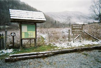
While the Overmountain Victory National Historic Trail stretches 330 miles, there are only a few segments that are not paved highway and open to the public. This page describes the 3.5 mile section located in the Hampton Creek Cove State Natural Area.
How to get there
From Johnson City, TN
- Head south on Roan Street for 3.5 miles passing under I-26.
- Take left/east onto TN359/Okolona Road and travel 1.4 miles.
- Take right/south onto TN361 over to US19E for nine miles. The road starts as Laurels Road, then Dry Creek Road and finally Gap Creek Road.
- Travel US19E for ten miles to town of Roan Mountain.
- Take right/south onto TN143.
- Cross bridge and then take left/east onto Stratton Street.
- Take right/south onto Old Highway 143/Sawdust Trail to Cloudland Elem School.
- Turn left/east onto Hampton Creek Road and proceed three miles.
- Parking area is on left/east side of road.
Route Description
The Overmountain Trail begins at the parking lot follows the Left Prong creek up Yellow Mountain to intersection with the Appalachian Trail at the gap. The path continues into North Carolina for another 1.5 miles.
Typical Conditions
Fees, Permits, etc.
No permit or fee. The nature area closes at dusk.
After the Hike
Misc. Information
Hampton Creek Cove is a 693-acre natural area. The official TN.gov Hampton Creek Cove webpage including map.
Maps
<googlemap lat="36.14" lon="-82.055733" type="terrain" zoom="14" height="600" scale="yes" icons="http://tehcc.org/clubwiki/kml/marker{label}.png"> http://tehcc.org/clubwiki/kml/Placeholder_trail.kml (A) 36.152383,-82.055733 Parking </googlemap>


