Little Stony Creek Falls: Difference between revisions
Jump to navigation
Jump to search
(Created page with "To be completed") |
(Created from existing PDF in club files) |
||
| Line 1: | Line 1: | ||
To | <!-- The following few lines create the "Infobox" table template. Please scroll down to edit the main content of the article. --> | ||
{{Infobox Trail | |||
| Image Name = Upper_Falls_of_Little_Stony_Creek.jpg | |||
| Trail No. = * | |||
| Hike Time = 3-4 | |||
| City = Dungannon | |||
| State = Virginia | |||
| Trail Use = {{Hike}}{{Dogs}} | |||
| Season = Year Round | |||
| Difficulty Rating = Moderate | |||
| Distance = 5.2 | |||
| Elevation Gain = 800 | |||
| High Point = * | |||
| Latitude = 36.794716 | |||
| Longitude = -82.547150 | |||
| Medical = Kingsport, TN | |||
<!-- DON'T EDIT THE GOOGLEMAP TAG --> | |||
| googlemap = | |||
<googlemap version="0.9" lat="36.794716" lon="-82.547150" type="terrain" zoom="13" width="270" height="180" selector="no" controls="small"> | |||
36.794716,-82.547150,Little Stony Creek Falls | |||
</googlemap> | |||
}} | |||
<!-- End Infobox template table--> | |||
<!-- Start of Main Page --> | |||
== Trail Overview == | |||
<!-- Enter a overview of the trail. What attracts you to this trail, points of interest, types of flowers, lakes, and peaks that you see along the way. --> | |||
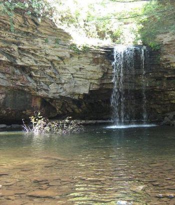
Two nice waterfalls in gorge with sandstone cliffs along the sides. Hike up good trail with several bridges. | |||
== How to get there == | |||
<!-- Please enter detailed instruction on how to find the trail head. --> | |||
From Gate City, VA: | |||
#Turn onto VA 71 north (no sign here). | |||
#After one mile, turn left on VA 72 and proceed north (through Ft. Blackmore and Dungannon, Va.) for 22.1 miles. | |||
#Look for USFS sign, to USFS Hanging Rock Recreation Area (about 2.6 miles north of Dungannon, Va). | |||
#At extremely sharp switchback, go straight (left side of highway) into picnic area and park. | |||
== Route Description== | |||
<!-- Detailed description of the route. Is there any side trails that are worth traveling? --> | |||
Hikers cross mound barriers and soon make the first of a number of fords. Continue following up creek valley. | |||
== Typical Conditions == | |||
<!-- Typical conditions throughout the year of what to expect on the trail. Rocky, muddy, sandy, flowers, lots of downed trees? --> | |||
Reported some blowdowns from 2009 storm still remaining. | |||
==Fees, Permits, etc. == | |||
<!-- Please list any Fees, Permits, Regulations, etc. that may be required on this trail.--> | |||
Day use fee for USFS Hanging Rock Recreation Area | |||
== After the Hike == | |||
<!-- Where to get a good meal after a long days hike. Because I know everyone will be hungry!! --> | |||
== Misc. Information == | |||
<!-- Enter any additional information that doesn't fit an any other fields. Does this trail require any permits for overnight? parking? --> | |||
== Maps == | |||
<!-- You can place pictures, PDF's, links, or even create a Google map with your waypoints and place it here. --> | |||
<!-- <googlemap version="0.9" lat="36.514327" lon="-82.478399" type="terrain" zoom="15" width="400" height="350" scale="yes" controls="large"> | |||
</googlemap> --> | |||
== Photos == | |||
<gallery> | |||
<!-- Place any pictures from this trail below. Add a picture by typing Image:imagename.extension --> | |||
Image:Placeholder.gif | |||
<!-- Do not remove the end gallery code.--> | |||
</gallery> | |||
<!-- Finally add the trail to any Categories it should belong to. Please keep the State category. To make a new category just type [[Category:mycategory]]. Keep in mind categories are case sensitive. --> | |||
[[Category:Warriors Path State Park]] [[Category:Kingsport]] [[Category:Dog Friendly]] [[Category:Medium]] | |||
Revision as of 17:41, 5 March 2011
| |||||||||||||||||||||||||||||||||||||
Trail Overview
Two nice waterfalls in gorge with sandstone cliffs along the sides. Hike up good trail with several bridges.
How to get there
From Gate City, VA:
- Turn onto VA 71 north (no sign here).
- After one mile, turn left on VA 72 and proceed north (through Ft. Blackmore and Dungannon, Va.) for 22.1 miles.
- Look for USFS sign, to USFS Hanging Rock Recreation Area (about 2.6 miles north of Dungannon, Va).
- At extremely sharp switchback, go straight (left side of highway) into picnic area and park.
Route Description
Hikers cross mound barriers and soon make the first of a number of fords. Continue following up creek valley.
Typical Conditions
Reported some blowdowns from 2009 storm still remaining.
Fees, Permits, etc.
Day use fee for USFS Hanging Rock Recreation Area
After the Hike
Misc. Information
Maps
Photos
- Placeholder.gif
