Charlies Bunion: Difference between revisions
Jump to navigation
Jump to search
Andysteffan (talk | contribs) No edit summary |
(add park) |
||
| Line 1: | Line 1: | ||
{{Trail | {{Trail | ||
|Trail Highlight=Lovely 180 degree views from a rock outcropping | |Trail Highlight=Lovely 180 degree views from a rock outcropping | ||
|Park=Great Smoky Mountains National Park | |||
|Trail System=Appalachian Trail | |Trail System=Appalachian Trail | ||
|Trail Marking=White AT Blaze | |Trail Marking=White AT Blaze | ||
Revision as of 14:03, 10 November 2021
| Charlies Bunion (log in to submit report) | |
|---|---|

| |
| Highlight | Lovely 180 degree views from a rock outcropping |
| Trail System | Appalachian Trail |
| Park | Great Smoky Mountains National Park |
| Located | , Location inherited from associated park |
| Trail Marking | White AT Blaze |
| Trail UseThings allowed to do on or near the trail | |
| FeaturesThings to see on or near the trail |
|
| Difficulty Rating | Medium |
| Hiking TimeTime from car and back. Includes any time hiking to access this trail. | 4.5 hrs0.281 Days <br />270 Min <br /> round trip |
| Distance: | 4 mi6.437 km <br /> trailStrict non-repeating trail length / 8.1 mi13.036 km <br /> round tripTypical or shortest length from the car, hike the trail, and return to car |
| Trail Type | In-and-Out |
| Low / High Point | 5000 ft1,666.667 Yards <br />1,524 Meters <br /> / 6100 ft2,033.333 Yards <br />1,859.28 Meters <br /> |
| Elev. Gain/LossSee link for details of calculation. Gain/Loss is direction dependent. | 1640 ft499.872 Meters <br /> / ({{{Elevation Loss}}}"{{{Elevation Loss}}}" is not a number.) – South-to-North |
| Trip ReportsFrom user "hiked it" submissions<br />Recent is within last 90 days | 1 logged hikes (0 recent) |
| NearbyWithin 5 mi<br />Click link to view list | 146The following coordinate was not recognized: . trails / 145.8 mi of trail |
| Parking | Map |
| Trailhead | Map |
|
| |
| Show In Google Maps | |
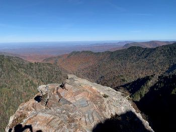
Great Smoky Mountains. Park at Newfound gap and take the AT eastbound. At roughly 1.8 miles, continue straight on the AT at the split for Sweat Heifer Creek Trail junction. At 2.7 miles, the trail splits again with a fork to the left to Mount Leconte on the Boulevard Trail and Jump Off trail (short one-mile round-trip adder hike to get to this overlook from the junction). For Charlies Bunion, continue straight (slight right) on the AT. You'll pass the Icewater Spring Shelter. At roughly 4 miles, there will be a short spur on the left taking you to the overlook.