The Channels Natural Area Preserve: Difference between revisions
(add trail stubs) |
(→Park Overview: tweak overview) |
||
| Line 16: | Line 16: | ||
==Park Overview== | ==Park Overview== | ||
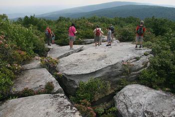
The Channels, the 53rd state natural area preserve, is an area of significant high elevation forest, rock outcrop and cliff communities. The preserve name is derived from the maze-like system of sandstone crevices and boulders that occur near the 4208ft. summit of Middle Knob on Clinch mountain. | The Channels, the 53rd state natural area preserve, is an area of significant high elevation forest, rock outcrop and cliff communities. The preserve name is derived from the maze-like system of sandstone crevices and boulders that occur near the 4208ft. summit of Middle Knob on Clinch mountain. | ||
The preserve itself is located within The Channels State Forest and the trails assigned to it exist well outside of the preserve, and partially outside of the forest. | |||
'''Note!:''' When people say they are going to The Channels, they are likely referring to hiking on the [[Brumley Mountain Trail]] (whether they know it or not). Also starting from the east end along VA-80 hiking west to reach The Channels in under three miles. See Park Trails section for more details. | '''Note!:''' When people say they are going to The Channels, they are likely referring to hiking on the [[Brumley Mountain Trail]] (whether they know it or not). Also starting from the east end along VA-80 hiking west to reach The Channels in under three miles. See Park Trails section for more details. | ||
Revision as of 20:04, 18 December 2019
| The Channels Natural Area Preserve | |
|---|---|

| |
| Park Type | State Natural Area |
| Located | Rosedale, Virginia |
| External Links | Official Website |
| Entrance Fee | Unknown |
| ActivitiesThings to do at the park | |
| Park AmenitiesThings built to enjoy or use at the park | |
| FeaturesNatural things to see at the park | |
| Park Trails |
2 Trails / Total of 8.36 miles13.454 km <br /> |
| Lodging Types | None |
| Park Area | 721 acres2.918 km² <br /> |
| Operated By | Virginia Department of Forestry |
| Main Location | Map |
|
| |
| Show In Google Maps | |
Download KML / Upload new version / KML File Page
Park Overview
The Channels, the 53rd state natural area preserve, is an area of significant high elevation forest, rock outcrop and cliff communities. The preserve name is derived from the maze-like system of sandstone crevices and boulders that occur near the 4208ft. summit of Middle Knob on Clinch mountain.
The preserve itself is located within The Channels State Forest and the trails assigned to it exist well outside of the preserve, and partially outside of the forest.
Note!: When people say they are going to The Channels, they are likely referring to hiking on the Brumley Mountain Trail (whether they know it or not). Also starting from the east end along VA-80 hiking west to reach The Channels in under three miles. See Park Trails section for more details.
How To Get There
Park Trails
The Channels Natural Area Preserve has the following 2 trails totaling 8.36 miles.
| Park Trails | Distance | Difficulty | Marking | Usage | Highlight |
|---|---|---|---|---|---|
| Brumley Mountain Trail | 2.96 mi | Medium | White diamond | Your likely trail if you want to "go to The Channels" | |
| Channels Trail | 5.40 mi | Hard | Red blaze | Although your likely goal, not the typical access |
Despite overwhelmingly used as the 3mi access to The Channels, the Brumley Mountain Trail is actually a 14.6 mile trail from a parking spot on Rt 690 to parking spot on VA-80.
An actual trail called Channels Trail does exist, but is a 5.5 mi trail starting from a parking spot on Rt. 689 that intersects on Brumley Mountain Trail
