Virginia Creeper Trail: Difference between revisions
m (add needs) |
(Convert to new form format) |
||
| Line 1: | Line 1: | ||
{{Trail | |||
|City=Damascus | |||
|Trail Marking=None | |||
|Trail Use=Hiking, Biking | |||
|Difficulty Rating=Medium | |||
|Hike Time=2 hrs | |||
|Trail Distance=34.67 mi | |||
|Round Trip Distance=34.67 mi | |||
|Trail Type=Segment | |||
|High Point=3,597 ft | |||
|Low Point=1,729 ft | |||
|Elevation Gain=694 ft | |||
|Elevation Loss=2,213 ft | |||
|Elevation Change Direction=East-to-West | |||
|Parking location=36.634266, -81.782570 | |||
|Trailhead location=36.634266, -81.782570 | |||
}} | |||
{{Trail Map}} | |||
__TOC__ | |||
== Trail Overview == | == Trail Overview == | ||
<!-- Enter a overview of the trail. What attracts you to this trail, points of interest, types of flowers, lakes, and peaks that you see along the way. --> | <!-- Enter a overview of the trail. What attracts you to this trail, points of interest, types of flowers, lakes, and peaks that you see along the way. --> | ||
| Line 80: | Line 64: | ||
<!-- Enter any additional information that doesn't fit an any other fields. Any seasonal features, factoids, etc...? --> | <!-- Enter any additional information that doesn't fit an any other fields. Any seasonal features, factoids, etc...? --> | ||
The trail is managed by the Virginia Creeper Trail Club. [http://www.vacreepertrail.org/ website] | The trail is managed by the Virginia Creeper Trail Club. [http://www.vacreepertrail.org/ website] | ||
== Photos == | == Photos == | ||
{{Park trail gallery|Trail={{PAGENAME}}}} | |||
{{Map Marker|Icon Type=Trail sign|Marker Title=Abingdon Trailhead|Marker Description=[[Image:Virginia_Creeper_Trail_-_Abingdon_Trailhead.jpg|150px]]|Marker Location=36.70925,-81.971633}} | |||
{{Map Marker|Icon Type=Trail sign|Marker Title=Watauga Trailhead|Marker Description= |Marker Location=36.6780,-81.9351}} | |||
{{Map Marker|Icon Type=Point of interest|Marker Title=Damascus|Marker Description= |Marker Location=36.634266,-81.782570}} | |||
Image:Virginia Creeper Trail - Alvarado Station.jpg| | {{Map Marker|Icon Type=Trail sign|Marker Title=Whitetop Trailhead|Marker Description= |Marker Location=36.599613,-81.624985}} | ||
{{Map Marker|Icon Type=Parking|Marker Title=Alvarado Station|Marker Description=[[Image:Virginia Creeper Trail - Alvarado Station.jpg|150px]]|Marker Location=36.6504,-81.8865}} | |||
{{Map Marker|Icon Type=Trail bridge|Marker Title=Trestle #12 over Holston River South and Middle Forks|Marker Description=[[Image:Virginia Creeper Trestle 12.jpg|150px]]|Marker Location=36.65458, -81.90332}} | |||
{{Map Marker|Icon Type=Parking|Marker Title=Green Cove Station|Marker Description=[[Image:VCT - Green Cove station.JPG|150px]]|Marker Location=36.61923, -81.64457}} | |||
[[ | |||
Revision as of 23:06, 21 December 2018
| Virginia Creeper Trail (log in to submit report) | |
|---|---|
| Located | Damascus, Virginia |
| Trail Marking | None |
| Trail UseThings allowed to do on or near the trail |
|
| FeaturesThings to see on or near the trail |
|
| Difficulty Rating | Medium |
| Hiking TimeTime from car and back. Includes any time hiking to access this trail. | 2 hrs0.125 Days <br />120 Min <br /> round trip |
| Distance: | 34.67 mi55.796 km <br /> trailStrict non-repeating trail length / 34.67 mi55.796 km <br /> round tripTypical or shortest length from the car, hike the trail, and return to car |
| Trail Type | Segment |
| Low / High Point | 1,729 ft576.333 Yards <br />526.999 Meters <br /> / 3,597 ft1,199 Yards <br />1,096.366 Meters <br /> |
| Elev. Gain/LossSee link for details of calculation. Gain/Loss is direction dependent. | 694 ft211.531 Meters <br /> / (2,213 ft674.522 Meters <br />) – East-to-West |
| Trip ReportsFrom user "hiked it" submissions<br />Recent is within last 90 days | No hikes logged yet |
| NearbyWithin 5 mi<br />Click link to view list | No other Trails within 5 mi |
| Parking | 36° 38' 3.36" N, 81° 46' 57.25" W Map |
| Trailhead | 36° 38' 3.36" N, 81° 46' 57.25" W Map |
|
| |
| Show In Google Maps | |
Download KML / Upload new version / KML File Page / Create Profile Chart / gpsvisualizer Map
Trail Overview
The Virginia Creeper Trail (VCT) is an excellent Rails-to-Trails conversion features forested path with 47 wooden trestles and bridges over creeks and rivers. Extremely popular bicycling ride.
How to get there
The VCTC website provides car GPS addresses for the trail access points:
- Abingdon Trailhead- 300 Green Spring Road, Abingdon, VA 24210
- Watauga Trailhead- 24350 Watauga Road, Abingdon, VA 24211
- Alvarado Station- 21198 Alvarado Road, Abingdon, VA 24211
- Damascus Town Park- 301 S Beaver Dam Ave, Damascus, VA 24236
- Straight Branch Trailhead- Near 25738 Jeb Stuart Highway, Jefferson National Forest Damascus, VA 24236
- Taylors Valley Trailhead- 23530 Taylor Valley Road, Jefferson National Forest, Damascus, VA 24236
- Creek Junction Trailhead- 21285 Creek Junction Road, Jefferson National Forest, Damascus, VA 24236
- Green Cove Station- Green Cove Community Center, 41221 County Road 600, Jefferson National Forest, Damascus, VA 24236
- Whitetop Station- Whitetop Gap Road, Whitetop, VA 24292 (Note: this is NOT Whitetop Mountain but the community of Whitetop, VA)
Route Description
The route is obvious due to its former railroad bed and well-worn path. There are two sets of mile markers - one for the former railroad, the other from Abingdon. The VCTC is also installing numbers on the trestles for more guidance and to aid emergency responders.
Out and back trips can be taken from any of the access points or shuttle can be arranged. Popular routes are taking a shuttle to Whitetop and riding 17 miles back down to Damascus or starting at Abingdon over to Damascus and back.
Typical Conditions
Wide gravel trail with wooden trestles from former railroad. Well maintained due to its high use.
Fees, Permits, etc.
The VCT is free to walk/ride. If you have your own bike and just need a shuttle (leaving between 8AM and 3PM), it's typically $14. Rental a bike for $15-18 (4 hours) or $20-21 (all day), and then the shuttle is around $10. Ride down from Whitetop to Damascus is considered half day, while all the way to Abingdon is full day.
The following bike shops are available in Damascus:
- JC's Outdoors
- Adventure Damascus Bicycles
- The Bike Station (warning: annoying cursor tail on website.)
- Blue Blaze Bike Rental (warning: annoying cursor tail on website.)
- Creeper Trail Bike Rental
And in Abingdon:
Misc. Information
The trail is managed by the Virginia Creeper Trail Club. website
Photos
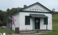
Green Cove Station
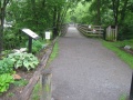
Abingdon Trailhead
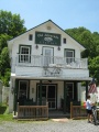
Alvarado Station
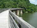
Trestle 12


