Raven Rock: Difference between revisions
Jump to navigation
Jump to search
(cleanup cats) |
m (add needs) |
||
| Line 1: | Line 1: | ||
<!-- The following few lines create the "Infobox" table template. Please scroll down to edit the main content of the article. --> | <!-- The following few lines create the "Infobox" table template. Please scroll down to edit the main content of the article. | ||
{{Infobox Trail | |||
-->{{Infobox Trail | |||
| Image Name = Roan View from Raven Rock.jpg | | Image Name = Roan View from Raven Rock.jpg | ||
| Park = Roan Mountain State Park | | Park = Roan Mountain State Park | ||
| Line 18: | Line 19: | ||
| Trailhead coords = 36.160400,-82.097376 | | Trailhead coords = 36.160400,-82.097376 | ||
| Medical = Elizabethton, TN | | Medical = Elizabethton, TN | ||
}} | }}<!-- | ||
<!-- End Infobox template table--> | |||
<!-- Start of Main Page --> | End Infobox template table | ||
-->{{Trail page needs | |||
| Hide needs = Yes | |||
| KML = | |||
| Updated KML = | |||
| Detail route description = | |||
| Photos = | |||
| Winter photos = | |||
| Remove prefix = | |||
| Update infobox = | |||
| Infobox data update = | |||
| Trail pins = | |||
| Other = | |||
| Comment = Looks good | |||
| Date reviewed = 11/21/2015 | |||
}}<!-- | |||
Start of Main Page --> | |||
== Trail Overview == | == Trail Overview == | ||
<!-- Enter a overview of the trail. What attracts you to this trail, points of interest, types of flowers, lakes, and peaks that you see along the way. --> | <!-- Enter a overview of the trail. What attracts you to this trail, points of interest, types of flowers, lakes, and peaks that you see along the way. --> | ||
Revision as of 11:19, 21 November 2015
| |||||||||||||||||||||||||||||||||||||||||||||

Trail Overview
A fairly easy hike with a great lookout payoff. Use this trail as a destination or an excursion of a longer circuit using Forest Road Trail or other trails. With its proximity to the campground, anyone staying the night there should take the time for the hike and the view.
How to get there
From the Visitor's Center
- Drive south on TN143
- Park at the pool and tennis court parking lot on your right
- The trail head is on the opposite side of the street from the turn off to the campground
- Hike along the Forest Road Trail for ~0.5 miles and turn right at the sign for Raven Rock Trail
Route Description
An extension of Forest Road Trail leading to a high point lookout.
Route description based on starting from Forest Road Trail head near the campground
| Miles Out | Raven Rock | Miles Back | Elevation (ft) |
|---|---|---|---|
| -0.12 | Begin at Forest Road Trail near campground | 1.65 | 2,940 |
| 0.0 | Raven Rock Trail head | 1.53 | 3,052 |
| 0.31 | Pass large rock hanging over trail | 1.22 | 3,279 |
| 0.37 | Raven Rock Overlook | 1.16 | 3,277 |
| 0.48 | Trail high point | 1.05 | 3,448 |
| 1.02 | Re-connect with Forest Road Trail | 0.51 | 3,043 |
| 1.41 | Re-pass the initial Raven Rock trail head | 0.12 | 3,052 |
| 1.53 | Return to beginning | 0.0 | 3,052 |
This trail is only accessible from Forest Road Trail.
Typical Conditions
Being a TN state park, the dirt and gravel trails are kept in good condition. Some of the trail sections are steep, thus can be slippery after a rain.
Misc. Information
Maps
Raven Rock Trail is shown below in its blaze color red.
Photos
-
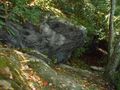
Large rock along the trail
