Luke Carter Trail: Difference between revisions
m (Corrected image name for infobox) |
(Added bridge pix and gravel road kml) |
||
| Line 76: | Line 76: | ||
== Maps == | == Maps == | ||
<!-- You can place pictures, PDF's, links, or even create a Google map with your waypoints and place it here. --> | <!-- You can place pictures, PDF's, links, or even create a Google map with your waypoints and place it here. --> | ||
Luke Carter Trail is shown as red line below. | Luke Carter Trail is shown as red line below. Walter Hopkins Trail is green. Gravel access roads in blue. | ||
<googlemap version="0.9" lat="36. | <googlemap version="0.9" lat="36.288" lon="-82.502" type="terrain" zoom="15" width="700" scale="yes" icons="http://tehcc.org/clubwiki/kml/marker{label}.png"> | ||
http://tehcc.org/clubwiki/kml/PRP_Luke_Carter_Trail.kml | http://tehcc.org/clubwiki/kml/PRP_Luke_Carter_Trail.kml | ||
http://tehcc.org/clubwiki/kml/PRP_Walter_Hopkins_Trail.kml | http://tehcc.org/clubwiki/kml/PRP_Walter_Hopkins_Trail.kml | ||
http://tehcc.org/clubwiki/kml/PRP_John_Tomko_Trail.kml | http://tehcc.org/clubwiki/kml/PRP_John_Tomko_Trail.kml | ||
http://tehcc.org/clubwiki/kml/PRP_Gravel_Road.kml | |||
(G) 36.28833,-82.4986 | (G) 36.28833,-82.4986 | ||
| Line 95: | Line 96: | ||
<!-- Place any pictures from this trail below. Ideally we would have a picture of the trailhead to help people know when they found it --> | <!-- Place any pictures from this trail below. Ideally we would have a picture of the trailhead to help people know when they found it --> | ||
<!-- Add a picture by typing Image:imagename.extension --> | <!-- Add a picture by typing Image:imagename.extension --> | ||
Image: | Image:PRP_Luke_Carter_trail_bridge.JPG|Very study bridge at west end of trail | ||
<!-- Do not remove the end gallery code.--> | <!-- Do not remove the end gallery code.--> | ||
</gallery> | </gallery> | ||
Revision as of 05:44, 14 August 2011
| |||||||||||||||||||||||||||||||||||||

Trail Overview
Located in Persimmon Ridge Park. A ridgeline hike through second generation hardwoods, gap view at powerline, and down to wooden bridge. Excellent young family trail due to nearby location and short length.
How to get there
Driving direction on main park page. Parking for the main trailhead is located by the playground area next to the campground. Trail begins behind the playground.
Route Description
Without a sign to definitively mark the western trailhead, used the wooden bridge as it also appears to be the start of Walter's Trail, thus the measured length of 0.7 miles is less than what was reported in the TN Greenways listing.
| Miles | Luke Carter Trail | Miles | Elevation |
|---|---|---|---|
| 0.0 | Trailhead at campground | 0.7 | 1775 |
| 0.1 | Up on ridgeline | 0.6 | 1905 |
| 0.4 | Gap for powerline - look down on Wetlands water park | 0.3 | 1865 |
| 0.7 | Bridge at western end of trail | 0.0 | 1705 |
Typical Conditions
Hard dirt trail with two switchbacks to get up to ridgeline. Might have had yellow blazes at one time, but could not see. Someone has removed several blowdowns from the winter and spring storms. No sign at western end to let you know about the trail - or how long.
Regulations
NO BIKES!
Misc. Information
The trail is named after Luke Carter, who led its construction for his Eagle Scout project. Might have been part of local Boy Scout Troop 39 (to be confirmed).
Maps
Luke Carter Trail is shown as red line below. Walter Hopkins Trail is green. Gravel access roads in blue.
<googlemap version="0.9" lat="36.288" lon="-82.502" type="terrain" zoom="15" width="700" scale="yes" icons="http://tehcc.org/clubwiki/kml/marker{label}.png"> http://tehcc.org/clubwiki/kml/PRP_Luke_Carter_Trail.kml http://tehcc.org/clubwiki/kml/PRP_Walter_Hopkins_Trail.kml http://tehcc.org/clubwiki/kml/PRP_John_Tomko_Trail.kml http://tehcc.org/clubwiki/kml/PRP_Gravel_Road.kml
(G) 36.28833,-82.4986
Eastern trailhead
File:PRP Luke Carter sign.JPG
(G) 36.283722,-82.502489
Western trailhead
 </googlemap>
Photos
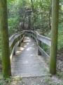
Very study bridge at west end of trail