Blackstack Cliffs (AT): Difference between revisions
Jump to navigation
Jump to search
| Line 40: | Line 40: | ||
== Route Description== | == Route Description== | ||
<!-- Detailed description of the route. Is there any side trails that are worth traveling? --> | <!-- Detailed description of the route. Is there any side trails that are worth traveling? --> | ||
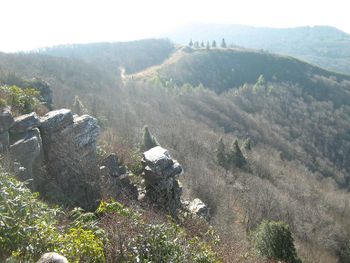
Upon Camp Creek Bald, find the blue blazes down the middle of a paved road which is the spur trail over to the AT. Head north-bound on the white-blazed AT for 0.4 miles. In a turn, there is a brown sign stated Blackstack Cliff for an unmarked spur trail up the hill. Continue through the rhododendron to a stone ledge with a US Forest benchmark. Take the big steps down and proceed through more rhododendron until you emerge at the cliffs. | |||
== Typical Conditions == | == Typical Conditions == | ||
Revision as of 16:30, 5 March 2011
| |||||||||||||||||||||||||||||||||||||
Trail Overview
A short spur off Applachian Trail through rhododendron leads to overlook from these cliffs - great lunch spot.
How to get there
From Greeneville, TN
- Take TN-107/TN-70 south out of town for 15 miles.
- Turn left onto Viking Mountain Road for 6.5 miles.
- Which becomes gravel Bald Mountain Road for last couple of miles.
- Park at turnaround
Route Description
Upon Camp Creek Bald, find the blue blazes down the middle of a paved road which is the spur trail over to the AT. Head north-bound on the white-blazed AT for 0.4 miles. In a turn, there is a brown sign stated Blackstack Cliff for an unmarked spur trail up the hill. Continue through the rhododendron to a stone ledge with a US Forest benchmark. Take the big steps down and proceed through more rhododendron until you emerge at the cliffs.
Typical Conditions
Fees, Permits, etc.
After the Hike
Misc. Information
Maps
File:Roaring Branch Trail - geocaches.JPG

