Laurel Fork Gorge: Difference between revisions
Jump to navigation
Jump to search
(→Maps: Adding map feature) |
m (→Photos: removing potato hill pix unless some can say why it belongs) |
||
| Line 75: | Line 75: | ||
<!-- Place any pictures from this trail below. Ideally we would have a picture of the trailhead to help people know when they found it --> | <!-- Place any pictures from this trail below. Ideally we would have a picture of the trailhead to help people know when they found it --> | ||
<!-- Add a picture by typing Image:imagename.extension --> | <!-- Add a picture by typing Image:imagename.extension --> | ||
Image: | Image:Placeholder.jpg | ||
<!-- Do not remove the end gallery code.--> | <!-- Do not remove the end gallery code.--> | ||
| Line 81: | Line 81: | ||
<!-- Finally add the trail to any Categories it should belong to. Please keep the State category. To make a new category just type [[Category:mycategory]]. Keep in mind categories are case sensitive. Check here ClubWIKI:Categorization_Plan for our list of categories that we are using --> | <!-- Finally add the trail to any Categories it should belong to. Please keep the State category. To make a new category just type [[Category:mycategory]]. Keep in mind categories are case sensitive. Check here ClubWIKI:Categorization_Plan for our list of categories that we are using --> | ||
[[Category:Tennessee]][[Category:Hiking]][[Category:Dog Friendly]][[Category:Waterfalls]][[Category:Medium]] | [[Category:Tennessee]] [[Category:Hiking]] [[Category:Dog Friendly]] [[Category:Waterfalls]] [[Category:Medium]] | ||
Revision as of 11:00, 29 July 2011
| |||||||||||||||||||||||||||||||||||||
Trail Overview
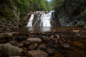
The Appalachian Trail travels through Laurel Fork Gorge, rarely straying far from Laurel Fork Creek. Probably the most popular hiking destination is Laurel Fork Falls, a 50' cascading waterfall. There are AT access points at both the NW end of the gorge (Hampton) and SE (Dennis Cove).
How to get there
Hampton
- From Elizabethton, go southeast on US 321 through Hampton for 1 mile
- Look for parking area on the right 36.28542,-82.15211
Dennis Cove
- From Elizabethton, go southeast on US 321 through Hampton for .8 miles
- Turn right (south) on FR 50 (Dennis Cove Road) and travel 2(?) miles
- Look for AT access parking area on your left 36.24618,-82.12311
Route Description
Typical Conditions
Fees, Permits, etc.
Per-vehicle use fee
After the Hike
Misc. Information
Maps
<googlemap version="0.9" lat="36.27277" lon="-82.135" type="terrain" zoom="13" width="725" scale="yes" icons="http://tehcc.org/clubwiki/kml/marker{label}.png"> http://tehcc.org/clubwiki/kml/Laurel_Fork_Gorge.kml
(C) 36.27277,-82.135 Laurel Fork Falls (G) 36.81945,-82.62895 Trailhead - Hampton (G) 36.264067, -82.1231 Trailhead - Dennis Cove </googlemap>
Photos
- Placeholder.jpg
