Sinking Waters: Difference between revisions
m (Test adding park trails list to this page) |
m (sinking water KML was renamed to follow trail naming convention) |
||
| Line 53: | Line 53: | ||
<!-- You can place pictures, PDF's, links, or even create a Google map with your waypoints and place it here. --> | <!-- You can place pictures, PDF's, links, or even create a Google map with your waypoints and place it here. --> | ||
<googlemap version="0.9" lat="36.514327" lon="-82.478399" type="terrain" zoom="15" width="400" height="350" scale="yes" controls="large" icons="http://tehcc.org/clubwiki/kml/marker{label}.png"> | <googlemap version="0.9" lat="36.514327" lon="-82.478399" type="terrain" zoom="15" width="400" height="350" scale="yes" controls="large" icons="http://tehcc.org/clubwiki/kml/marker{label}.png"> | ||
http://tehcc.org/clubwiki/kml/ | http://tehcc.org/clubwiki/kml/WPSP_sinking_water.kml | ||
(B) 36.51005, -82.481275 | (B) 36.51005, -82.481275 | ||
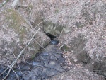
[[Image:Sinking Waters sinkhole.jpg|150px|The namesake sinking waters disappearing into a hole]] | [[Image:Sinking Waters sinkhole.jpg|150px|The namesake sinking waters disappearing into a hole]] | ||
Revision as of 20:11, 2 April 2011
| |||||||||||||||||||||||||||||||||||||
Trail Overview
Located in Warriors Path State Park. Nice quick hike nearby for those in Kingsport. Interesting view of a stream flowing and disappearing into a sink hole (thus the name sinking waters). Can also be made part of a nice jogging route. Also a good location for blackberries and raspberries during the warm summer months.
How to get there
Take Fort Henry to Hemlock Rd. Make the hard left to follow the road on to Fall Creek Rd, go across the bridge. Turn left on Moody and take until it meets Cedar Branch Rd and turn left. The parking area will be on your left as the road makes a hard right.
Route Description
There are two side tracks that can be taken to get up on to the ridge for some nice views to the south.
Typical Conditions
The trails are fairly well maintained with boardwalks in the wetter parts and stairs on the steeper parts.
Fees, Permits, etc.
None needed, just park and go.
After the Hike
Misc. Information
Maps
<googlemap version="0.9" lat="36.514327" lon="-82.478399" type="terrain" zoom="15" width="400" height="350" scale="yes" controls="large" icons="http://tehcc.org/clubwiki/kml/marker{label}.png">
http://tehcc.org/clubwiki/kml/WPSP_sinking_water.kml
(B) 36.51005, -82.481275
 </googlemap>

