Towhee Trail: Difference between revisions
Jump to navigation
Jump to search
m remove old needs |
add map marker |
||
| (2 intermediate revisions by the same user not shown) | |||
| Line 1: | Line 1: | ||
{{Trail | |||
|Park=Bays Mountain Park | |||
|Land Owner=City of Kingsport | |||
|Trail Marking=Signs | |||
|Trail Use=Hiking, Geocaching | |||
|Trail Features=Lakes, Mountains | |||
|Difficulty Rating=Easy | |||
|Hike Time=1.5 hr | |||
|Trail Distance=503 ft | |||
|Round Trip Distance=2.3 mi | |||
|Trail Type=Loop | |||
|High Point=1,893 ft | |||
|Low Point=1,882 ft | |||
|Elevation Gain=0 ft | |||
|Elevation Loss=8 ft | |||
|Elevation Change Direction=North-to-South | |||
|Parking location=36.50882, -82.60955 | |||
|Trailhead location=36.5128, -82.61328 | |||
}} | |||
{{Trail Map|Other Trails=Lake Road (Bays Mountain Park),Lakeside Trail}} | |||
__TOC__ | |||
== Trail Overview == | == Trail Overview == | ||
Located in [[Bays Mountain Park]]. Very short connector trail between [[Lakeside Trail|Lakeside Trail]] and [[Lake Road (Bays Mountain Park)|Lake Road]]. | Located in [[Bays Mountain Park]]. Very short connector trail between [[Lakeside Trail|Lakeside Trail]] and [[Lake Road (Bays Mountain Park)|Lake Road]]. | ||
| Line 50: | Line 29: | ||
== Route Description== | == Route Description== | ||
[[File:Towhee trail profile.png|thumb|right]] | |||
Very short 0.1 mile trail linking [[Trail connects to::Lake Road (Bays Mountain Park)|Lake Road]] and [[Trail connects to::Lakeside Trail]]. | Very short 0.1 mile trail linking [[Trail connects to::Lake Road (Bays Mountain Park)|Lake Road]] and [[Trail connects to::Lakeside Trail]]. | ||
| Line 74: | Line 53: | ||
== Regulations == | == Regulations == | ||
NO BIKES! | NO BIKES! | ||
== Photos == | == Photos == | ||
{{Park trail gallery|Trail={{PAGENAME}}}} | |||
{{Map Marker|Icon Type=Trail sign|Marker Title=Junction with [[Lakeside Trail|Lakeside Trail]]|Marker Description= |Marker Location=36.51147,-82.61314}} | |||
[[ | |||
Latest revision as of 23:30, 15 December 2019
| Towhee Trail (log in to submit report) | |
|---|---|
| Park | Bays Mountain Park |
| Land Owner | City of Kingsport |
| Located | Kingsport, TennesseeLocation inherited from associated park |
| Trail Marking | Signs |
| Trail UseThings allowed to do on or near the trail |
|
| FeaturesThings to see on or near the trail |
|
| Difficulty Rating | Easy |
| Hiking TimeTime from car and back. Includes any time hiking to access this trail. | 1.5 hr0.0938 Days <br />90 Min <br /> round trip |
| Distance: | 503 ft0.0953 Mi <br />0.153 km <br /> trailStrict non-repeating trail length / 2.3 mi3.701 km <br /> round tripTypical or shortest length from the car, hike the trail, and return to car |
| Trail Type | Loop |
| Low / High Point | 1,882 ft627.333 Yards <br />573.634 Meters <br /> / 1,893 ft631 Yards <br />576.986 Meters <br /> |
| Elev. Gain/LossSee link for details of calculation. Gain/Loss is direction dependent. | 0 ft0 Meters <br /> / (8 ft2.438 Meters <br />) – North-to-South |
| Trip ReportsFrom user "hiked it" submissions<br />Recent is within last 90 days | No hikes logged yet |
| NearbyWithin 5 mi<br />Click link to view list | 30 trails / 38.4 mi of trail |
| Parking | 36° 30' 31.75" N, 82° 36' 34.38" W Map |
| Trailhead | 36° 30' 46.08" N, 82° 36' 47.81" W Map |
|
| |
| Show In Google Maps | |


GeoJson Page / Create Profile Chart / gpsvisualizer Map / Legacy: Download KML / KML File Page
Trail Overview
Located in Bays Mountain Park. Very short connector trail between Lakeside Trail and Lake Road.
How to get there
The trail is not directly accessible from the main parking lot. Follow either Lakeside Trail or or Lake Road are to the far side of the reservoir.
Route Description

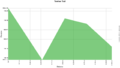
Very short 0.1 mile trail linking Lake Road and Lakeside Trail.
| Miles | Towhee Trail | Miles |
|---|---|---|
| 0.0 | Trailhead at Lakeside Trail | 0.1 |
| 0.1 | Trailhead at Lake Road | 0.0 |
Typical Conditions
Needled covered dirt trail with unfortunately lots to dying hemlocks in area.
Regulations
NO BIKES!
Photos
-
 Trail Profile