Azalea: Difference between revisions
(Changed to Regulations) |
(add map markers) |
||
| (27 intermediate revisions by 3 users not shown) | |||
| Line 1: | Line 1: | ||
{{Trail | |||
{{ | |Banner Image=File:BMP Azalea Trail.JPG | ||
|Park=Bays Mountain Park | |||
|Land Owner=City of Kingsport | |||
|Trail Marking=Signs | |||
|Trail Use=Hiking, Biking, Geocaching | |||
|Trail Features=Vistas | |||
|Difficulty Rating=Hard | |||
|Hike Time=1.5 hrs | |||
|Trail Distance=1.372 mi | |||
|Round Trip Distance=3.8 mi | |||
|Trail Type=Segment | |||
|High Point=2,241 Ft | |||
|Low Point=1,857 ft | |||
|Elevation Gain=378 Ft | |||
|Elevation Loss=6 Ft | |||
|Elevation Change Direction=West-to-East | |||
36. | |Parking location=36.50882, -82.60955 | ||
|Trailhead location=36.51263, -82.60512 | |||
}} | }} | ||
{{Trail Map|Other Trails=Lake Road (Bays Mountain Park),River Mountain Road,Cross Ridges Trail,Pretty Ridge Trail,Front Hollow Road}} | |||
__TOC__ | |||
== Trail Overview == | == Trail Overview == | ||
<!-- Enter a overview of the trail. What attracts you to this trail, points of interest, types of flowers, lakes, and peaks that you see along the way. --> | <!-- Enter a overview of the trail. What attracts you to this trail, points of interest, types of flowers, lakes, and peaks that you see along the way. --> | ||
Located in [[Bays Mountain Park]]. Run or ride up to the Antennas via a trail straight up the hollow. "Azalea" Trail is a misnomer as there are no azaleas along this path, but a forest of maples, tulip | Located in [[Bays Mountain Park]]. Run or ride up to the Antennas via a trail straight up the hollow. "Azalea" Trail is a misnomer as there are no azaleas along this path, but a forest of maples, tulip poplars, ferns, and other hardwoods to enjoy. | ||
== How to get there == | == How to get there == | ||
| Line 34: | Line 32: | ||
== Route Description== | == Route Description== | ||
<!-- Detailed description of the route. Is there any side trails that are worth traveling? --> | <!-- Detailed description of the route. Is there any side trails that are worth traveling? --> | ||
The path runs right up the hollow along side | The path runs right up the hollow along side of an intermittent runoff stream. One up on Bays Mountain Road, many folks would continue up to the Antennas for the view of downtown Kingsport. | ||
The trail has connections to [[Trail connects to::Lake Road (Bays Mountain Park)]], [[Trail connects to::Big Oak Trail]], [[Trail connects to::River Mountain Road]], [[Trail connects to::Bays Mountain Road]] | |||
<tab class=wikitable sep=comma head=top> | |||
Miles,Azalea Trail,Miles,Elevation (ft) | |||
0.0,Trailhead at [[Lake Road (Bays Mountain Park)|Lake Road]],1.4,1860 | |||
1.0,Junction with [[Big Oak Trail|Big Oak Trail]],0.4, | |||
1.4,Trailhead at [[Bays Mountain Road|Bays Mountain Road]],0.0,2250 | |||
</tab> | |||
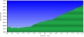
:::The following elevation profile proceeds from Lake Road to Bays Mountain Road. | |||
[[Image:BMP_Azalea_Trail_profile.JPG]] | |||
== Typical Conditions == | == Typical Conditions == | ||
| Line 62: | Line 52: | ||
<!-- Please list any Fees, Permits, Regulations, etc. that may be required on this trail.--> | <!-- Please list any Fees, Permits, Regulations, etc. that may be required on this trail.--> | ||
Do not mess with the electrical boxes along the trail - they are live! | Do not mess with the electrical boxes along the trail - they are live! | ||
== Photos == | == Photos == | ||
{{Park trail gallery|Trail={{PAGENAME}}}} | |||
{{Map Marker|Icon Type=Point of interest|Marker Title=Trailhead at [[Lake Road|Lake Road]]|Marker Description=[[Image:BMP Azalea Trail sign.JPG|50px]]|Marker Location=36.51262,-82.60520}} | |||
{{Map Marker|Icon Type=Point of interest|Marker Title=Trailhead at [[Bays Mountain Road|Bays Mountain Road]]|Marker Description=[[Image:BMP Azalea Trail sign at BMR.JPG|50px]]|Marker Location=36.52614,-82.58772}} | |||
{{Map Marker|Icon Type=Point of interest|Marker Title=Intersection at [[Big Oak Trail|Big Oak Trail]]|Marker Description=[[Image:BMP Split at Azalea and Big Oak Trails.JPG|100px]]|Marker Location=36.52221,-82.59283}} | |||
[[ | |||
Latest revision as of 23:34, 22 November 2019
| Azalea (log in to submit report) | |
|---|---|

| |
| Park | Bays Mountain Park |
| Land Owner | City of Kingsport |
| Located | Kingsport, TennesseeLocation inherited from associated park |
| Trail Marking | Signs |
| Trail UseThings allowed to do on or near the trail |
|
| FeaturesThings to see on or near the trail |
|
| Difficulty Rating | Hard |
| Hiking TimeTime from car and back. Includes any time hiking to access this trail. | 1.5 hrs0.0938 Days <br />90 Min <br /> round trip |
| Distance: | 1.372 mi2.208 km <br /> trailStrict non-repeating trail length / 3.8 mi6.115 km <br /> round tripTypical or shortest length from the car, hike the trail, and return to car |
| Trail Type | Segment |
| Low / High Point | 1,857 ft619 Yards <br />566.014 Meters <br /> / 2,241 Ft747 Yards <br />683.057 Meters <br /> |
| Elev. Gain/LossSee link for details of calculation. Gain/Loss is direction dependent. | 378 Ft115.214 Meters <br /> / (6 Ft1.829 Meters <br />) – West-to-East |
| Trip ReportsFrom user "hiked it" submissions<br />Recent is within last 90 days | 3 logged hikes (0 recent) |
| NearbyWithin 5 mi<br />Click link to view list | 30 trails / 37.1 mi of trail |
| Parking | 36° 30' 31.75" N, 82° 36' 34.38" W Map |
| Trailhead | 36° 30' 45.47" N, 82° 36' 18.43" W Map |
|
| |
| Show In Google Maps | |
Download KML / Upload new version / KML File Page / Create Profile Chart / gpsvisualizer Map
Trail Overview[edit]
Located in Bays Mountain Park. Run or ride up to the Antennas via a trail straight up the hollow. "Azalea" Trail is a misnomer as there are no azaleas along this path, but a forest of maples, tulip poplars, ferns, and other hardwoods to enjoy.
How to get there[edit]
From the main parking lot, pass through or around the bird and wolf habitats to reach Lake Road. Continue around to marked trailhead.
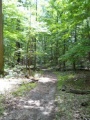
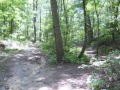
Route Description[edit]
The path runs right up the hollow along side of an intermittent runoff stream. One up on Bays Mountain Road, many folks would continue up to the Antennas for the view of downtown Kingsport.
The trail has connections to Lake Road (Bays Mountain Park), Big Oak Trail, River Mountain Road, Bays Mountain Road
| Miles | Azalea Trail | Miles | -Elevation (ft) |
|---|---|---|---|
| 0.0 | Trailhead at Lake Road | 1.4 | 1860 |
| 1.0 | Junction with Big Oak Trail | 0.4 | |
| 1.4 | Trailhead at Bays Mountain Road | 0.0 | 2250 |
- The following elevation profile proceeds from Lake Road to Bays Mountain Road.

Typical Conditions[edit]
Hard packed and sometimes rutted trail. The runoff stream can flow down the trail during spring or hard rains. Park does a great job of cutting through the blowdowns.
Regulations[edit]
Do not mess with the electrical boxes along the trail - they are live!
Photos[edit]


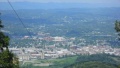
Overlook of downtown Kingsport


