Wahoo: Difference between revisions
m (add needs) |
(convert to new trail template) |
||
| Line 1: | Line 1: | ||
{{Trail | |||
|Trail System=Warriors' Path State Park Mountain Bike Trails | |||
|Trail Marking=None | |||
|Trail Use=Hiking, Biking | |||
|Trail Features=Vistas, Rivers | |||
|Difficulty Rating=Medium | |||
|Hike Time=1.5 hrs | |||
|Trail Distance=1.72 mi | |||
|Round Trip Distance=3.66 mi | |||
|Trail Type=Loop | |||
|High Point=1,494 Ft | |||
|Low Point=1,266 ft | |||
|Elevation Gain=204 Ft | |||
|Elevation Loss=204 Ft | |||
|Elevation Change Direction=Clockwise | |||
|Parking location=36.49213, -82.46857 | |||
|Trailhead location=36.486702,-82.474977 | |||
}} | |||
<display_map center="36.487475,-82.471555" type="terrain" zoom="16" width="auto" height="550" gkml="http://tehcc.org/clubwiki/kml/WPSP_Wahoo.kml, | |||
http://tehcc.org/clubwiki/kml/WPSP_Darwins_Revenge.kml"> | |||
}}< | 36.486702,-82.474977~Wahoo Trail Head~ ~MarkerG.png | ||
36.485607,-82.475936~Water Access~ ~MarkerJ.png | |||
36.485078,-82.476153~Lookout~View of bridges~MarkerE.png | |||
36.484770,-82.475452~Under I-81~ ~MarkerG.png | |||
36.484524,-82.474725~Resting bench~ ~MarkerK.png | |||
36.484605,-82.474501~Short bridge~ ~MarkerL.png | |||
36.483749,-82.471512~Private structure off trail right~ ~MarkerG.png | |||
36.487941,-82.467592~In power line cut~ ~MarkerG.png | |||
36.484483,-82.474199~Wahoo Split~ ~MarkerG.png | |||
</display_map> | |||
Darwin's Revenge is the red line. | |||
__TOC__ | |||
== Trail Overview == | == Trail Overview == | ||
<!-- Enter a overview of the trail. What attracts you to this trail, points of interest, types of flowers, lakes, and peaks that you see along the way. --> | <!-- Enter a overview of the trail. What attracts you to this trail, points of interest, types of flowers, lakes, and peaks that you see along the way. --> | ||
| Line 156: | Line 148: | ||
<!-- Please list any Fees, Permits, Regulations, etc. that may be required on this trail.--> | <!-- Please list any Fees, Permits, Regulations, etc. that may be required on this trail.--> | ||
No fee required. Dogs are allowed on or off leash. Do not drink any water without treatment! | No fee required. Dogs are allowed on or off leash. Do not drink any water without treatment! | ||
== Photos == | == Photos == | ||
{{Park trail gallery|Trail={{PAGENAME}}}} | |||
Revision as of 14:56, 7 December 2018
| Wahoo (log in to submit report) | |
|---|---|
| Trail System | Warriors' Path State Park Mountain Bike Trails |
| Located | |
| Trail Marking | None |
| Trail UseThings allowed to do on or near the trail |
|
| FeaturesThings to see on or near the trail |
|
| Difficulty Rating | Medium |
| Hiking TimeTime from car and back. Includes any time hiking to access this trail. | 1.5 hrs0.0938 Days <br />90 Min <br /> round trip |
| Distance: | 1.72 mi2.768 km <br /> trailStrict non-repeating trail length / 3.66 mi5.89 km <br /> round tripTypical or shortest length from the car, hike the trail, and return to car |
| Trail Type | Loop |
| Low / High Point | 1,266 ft422 Yards <br />385.877 Meters <br /> / 1,494 Ft498 Yards <br />455.371 Meters <br /> |
| Elev. Gain/LossSee link for details of calculation. Gain/Loss is direction dependent. | 204 Ft62.179 Meters <br /> / (204 Ft62.179 Meters <br />) – Clockwise |
| Trip ReportsFrom user "hiked it" submissions<br />Recent is within last 90 days | 1 logged hikes (0 recent) |
| NearbyWithin 5 mi<br />Click link to view list | 25 trails / 19.6 mi of trail |
| Parking | 36° 29' 31.67" N, 82° 28' 6.85" W Map |
| Trailhead | 36° 29' 12.13" N, 82° 28' 29.92" W Map |
|
| |
| Show In Google Maps | |
Darwin's Revenge is the red line.
Trail Overview
Although part of the Warriors Path State Park mountain bike trail system, the portion of this trail beyond I-81 is technically TVA managed public land. Most notable is that hunting is allowed on this property in accordance with state regulation.
Wahoo is only accessible from Darwin's Revenge.
How to get there
From main entrance of Warriors Path State Park:
- Go north on Fall Creek Road for 2.4 miles.
- Turn right (east) onto Old Mill Road for 0.8 miles.
- Turn right (south) onto Childress Ferry Road for just roughly 100 yards.
- Turn left (east) onto Buttermilk Road for 1.2 miles.
- Turn right (south) onto Freeman Road for 0.5 mile.
- Continue when road changes from asphalt to gravel.
Trailhead at gravel parking lot.
Route Description
If your goal is just Wahoo, the quickest way is to begin on Lake Road until you see the sign for Darwin's Revenge to the left. This is the Darwin's Connector and is a wide path, possibly an old road that tee's up to Darwin's Revenge. Turn to the right and take the trail until you see the sign for Wahoo.
| Miles Out | Wahoo | Miles Back | Elevation (ft) |
|---|---|---|---|
| -0.78 | At Parking lot | 2.88 | 1,469 |
| -0.68 | Connect with Darwin's Revenge | 2.78 | 1,511 |
| -0.28 | Split (green/black) in trail - Reroute? | 2.38 | 1,507 |
| -0.18 | Split reconvenes | 2.28 | 1,423 |
| -0.11 | Trail bridge over deep creek | 2.21 | 1,390 |
| 0.00 | Split to Wahoo | 2.1 | 1,332 |
| 0.1 | Water Access | 2.0 | 1,273 |
| 0.17 | Lookout to bridges | 1.93 | 1,290 |
| 0.24 | Under I-81 | 1.86 | 1,346 |
| 0.29 | Bench and stream to river | 1.81 | 1,320 |
| 0.32 | Split for loop (continuing counterclockwise) | 1.78 | 1,469 |
| 0.59 | Private structure off trail right | 1.51 | 1,420 |
| 1.0 | In power line cut | 1.1 | 1,497 |
| 1.78 | Complete loop | 0.32 | 1,469 |
| 2.1 | Wahoo Complete | 0.0 | 1,332 |
| 2.88 | At Parking lot | -0.78 | 1,469 |
Typical Conditions
The mountain biking association SORBA Tri-Cities handles the trail maintenance, thus generally in good condition. While there are no blazes to guide you through the forest, the narrow single tracks are well established. Grab a trail map at the parking lot kiosk to help you decipher intersections; some which could use signs. Be aware for approaching bike riders who can come up quickly on your group. Step aside to let them safely pass.
Fees, Permits, etc.
No fee required. Dogs are allowed on or off leash. Do not drink any water without treatment!
Photos
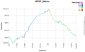
Wahoo Elevation Profile
