Azalea: Difference between revisions
(add note that page has hike description) |
(change type to segment and detail roundtrip beginning at dam, and trail connections) |
||
| Line 8: | Line 8: | ||
| Marking = Junction Signs | | Marking = Junction Signs | ||
| Trail Use = {{Hike}} {{Biking}} {{Dogs}} | | Trail Use = {{Hike}} {{Biking}} {{Dogs}} | ||
| Difficulty Rating = | | Difficulty Rating = Medium | ||
| Hike Time = 30 Min | | Hike Time = 30 Min | ||
| Round Trip Distance = | | Round Trip Distance = 3.84 Mi | ||
| Trail Distance = 1.39 Mi | | Trail Distance = 1.39 Mi | ||
| Trail Type = | | Trail Type = Segment | ||
| Elevation Gain = 616 Ft | | Elevation Gain = 616 Ft | ||
| Elevation Loss = -190 Ft | | Elevation Loss = -190 Ft | ||
| Line 33: | Line 33: | ||
<!-- Detailed description of the route. Is there any side trails that are worth traveling? --> | <!-- Detailed description of the route. Is there any side trails that are worth traveling? --> | ||
The path runs right up the hollow along side of an intermittent runoff stream. One up on Bays Mountain Road, many folks would continue up to the Antennas for the view of downtown Kingsport. | The path runs right up the hollow along side of an intermittent runoff stream. One up on Bays Mountain Road, many folks would continue up to the Antennas for the view of downtown Kingsport. | ||
The trail has connections to [[Trail connects to::Lakeside Trail]], [[Trail connects to::Big Oak Trail]], [[Trail connects to::River Mountain Road]], [[Trail connects to::Bays Mountain Road]] | |||
{| class="wikitable" border="1" | {| class="wikitable" border="1" | ||
| Line 42: | Line 44: | ||
|- | |- | ||
|0.0 | |0.0 | ||
|Trailhead at [[Lake Road|Lake Road]] | |Trailhead at [[Lake Road (Bays Mountain Park)|Lake Road]] | ||
|1.4 | |1.4 | ||
|1860 | |1860 | ||
Revision as of 10:11, 4 October 2015
| |||||||||||||||||||||||||||||||||||||||||||||

Trail Overview
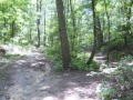
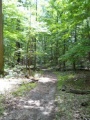
Located in Bays Mountain Park. Run or ride up to the Antennas via a trail straight up the hollow. "Azalea" Trail is a misnomer as there are no azaleas along this path, but a forest of maples, tulip poplars, ferns, and other hardwoods to enjoy.
How to get there
From the main parking lot, pass through or around the bird and wolf habitats to reach Lake Road. Continue around to marked trailhead.
Route Description
The path runs right up the hollow along side of an intermittent runoff stream. One up on Bays Mountain Road, many folks would continue up to the Antennas for the view of downtown Kingsport.
The trail has connections to Lakeside Trail, Big Oak Trail, River Mountain Road, Bays Mountain Road
| Miles | Azalea Trail | Miles | Elevation (ft) |
|---|---|---|---|
| 0.0 | Trailhead at Lake Road | 1.4 | 1860 |
| 1.0 | Junction with Big Oak Trail | 0.4 | |
| 1.4 | Trailhead at Bays Mountain Road | 0.0 | 2250 |
Typical Conditions
Hard packed and sometimes rutted trail. The runoff stream can flow down the trail during spring or hard rains. Park does a great job of cutting through the blowdowns.
Regulations
Do not mess with the electrical boxes along the trail - they are live!
Misc. Information
Maps
- The following elevation profile proceeds from Lake Road to Bays Mountain Road.

Photos

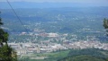
Overlook of Kingsport downtown