Cherry Knobs: Difference between revisions
(Update IB to new format) |
(→Maps: Updating for new Maps extension) |
||
| Line 73: | Line 73: | ||
The track for Cherry Knobs Trail is shown in green. Lakeside Trail in yellow. Lake Road in orange. Cross Ridges Trail in red. | The track for Cherry Knobs Trail is shown in green. Lakeside Trail in yellow. Lake Road in orange. Cross Ridges Trail in red. | ||
< | <display_map type="terrain" width="90%" height="500" gkml="http://tehcc.org/clubwiki/kml/BMP_Cherry_Knobs_Trail.kml, | ||
http://tehcc.org/clubwiki/kml/BMP_Cherry_Knobs_Trail.kml | http://tehcc.org/clubwiki/kml/BMP_lake_road-partial.kml, | ||
http://tehcc.org/clubwiki/kml/BMP_lake_road-partial.kml | http://tehcc.org/clubwiki/kml/BMP_lakeside_trail.kml, | ||
http://tehcc.org/clubwiki/kml/BMP_lakeside_trail.kml | http://tehcc.org/clubwiki/kml/BMP_Cross_Ridges_Trail.kml"> | ||
http://tehcc.org/clubwiki/kml/BMP_Cross_Ridges_Trail.kml | |||
36.50584,-82.61830~Junction with [[BMP Lakeside Trail|Lakeside Trail]]~ ~MarkerG.png | |||
Junction with [[BMP Lakeside Trail|Lakeside Trail]] | 36.50544,-82.61897~Spur trail to cemetery~ ~MarkerG.png | ||
36.50483,-82.61858~Half dozen headstones around a small clearing~ ~MarkerN.png | |||
Spur trail to cemetery | 36.50342,-82.62847~Junction with [[BMP Lake Road|Lake Road]]~[[Image:BMP CK LR sign1.JPG|50px]]~MarkerG.png | ||
36.500972,-82.630974~Junction with [[BMP Lake Road|Lake Road]]~[[Image:BMP CK LR sign2.JPG|50px]]~MarkerG.png | |||
Half dozen headstones around a small clearing | 36.49683,-82.63629~Junction with [[BMP Cross Ridges Trail|Cross Ridges Trail]]~[[Image:BMP CK-CR sign.JPG|50px]]~MarkerG.png | ||
</display_map> | |||
Junction with [[BMP Lake Road|Lake Road]] | |||
[[Image:BMP CK LR sign1.JPG|50px]] | |||
Junction with [[BMP Lake Road|Lake Road]] | |||
[[Image:BMP CK LR sign2.JPG|50px]] | |||
Junction with [[BMP Cross Ridges Trail|Cross Ridges Trail]] | |||
[[Image:BMP CK-CR sign.JPG|50px]] | |||
</ | |||
Revision as of 22:13, 22 August 2015
| |||||||||||||||||||||||||||||||||||||
Trail Overview
Located in Bays Mountain Park. There are no cherry trees along this trail, but a steep path up and along the Cherry Knobs - which can be noted on topo maps. High view of the reservoir.
How to get there
The trail is not directly accessible from the main parking lot. Most folks will cross the dam and follow Lakeside Trail over the floating bridge unti a Cherry Knobs trail sign is seen.
Route Description
Steep trail up and along the Cherry Knobs. Trekking poles might be useful to transfer weight off legs.
| Miles | Cherry Knobs Trail | Miles |
|---|---|---|
| 0.0 | Trailhead at Lakeside Trail | 1.6 |
| 0.05 | Spur trail to abandoned cemetery. One of three reported within Bays Mountain Park. | 1.55 |
| 0.7 | Junction with Lake Road. Both travel together for 0.3 miles. | 0.9 |
| 1.0 | Junction with Lake Road. To SW, light blue vinyl blazes. | 0.6 |
| 1.6 | Trailhead at Cross Ridges Trail | 0.0 |
Typical Conditions
Between Lakeside Trail and Lake Road, the dirt and leaf-covered path head up the Cherry Knobs. The piece shared with Lake Road is wide gravel road popular with mountain biking. Between Lake Road and Cross Ridges Trail, the path is much less used thus less maintained, so many small trees and briars grow along the path. The light blue vinyl blazes fortunately guide you.
Regulations
NO BIKES!
Misc. Information
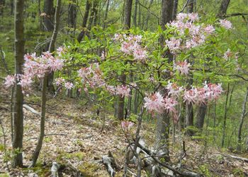
Pink azaleas can be found in the park, which would be the flowering tree similar to a cherry.
Maps
The track for Cherry Knobs Trail is shown in green. Lakeside Trail in yellow. Lake Road in orange. Cross Ridges Trail in red.
- The following elevation profile travels from Lakeside Trail to Cross Ridges Trail.
File:BMP Cherry Knobs Trail profile.JPG

