Chimney Top: Difference between revisions
m (→Maps) |
m (→Trail Overview) |
||
| Line 26: | Line 26: | ||
== Trail Overview == | == Trail Overview == | ||
<!-- Enter a overview of the trail. What attracts you to this trail, points of interest, types of flowers, lakes, and peaks that you see along the way. --> | <!-- Enter a overview of the trail. What attracts you to this trail, points of interest, types of flowers, lakes, and peaks that you see along the way. --> | ||
The volcano-appearing summit south of Kingsport is the 3,118 ft highpoint of Hawkins County. Great views of the | The volcano-appearing summit south of Kingsport is the 3,118 ft highpoint of Hawkins County. Great views of the I-81 valley and overlooking [[Bays Mountain Park]] to the southwest. Former airport beacon and short firetower also remain on the summit. | ||
== How to get there == | == How to get there == | ||
Revision as of 12:16, 18 April 2011
| |||||||||||||||||||||||||||||||||||||
Trail Overview
The volcano-appearing summit south of Kingsport is the 3,118 ft highpoint of Hawkins County. Great views of the I-81 valley and overlooking Bays Mountain Park to the southwest. Former airport beacon and short firetower also remain on the summit.
How to get there
From Kingsport downtown:
- Take Highway TN93 south.
- Roughly six miles out, turn right onto Horton Highway.
- Turn right at Chimney Top Loop (actually, the second right is shorter).
- After half mile, turn left onto gravel Sugar Hollow Lane.
- Proceed uphill past and seemingly through yards to Faulkner’s home.
- Park down below the house.
Trailhead is behind the right front corner of their garage down the narrow steep path to an old logging road.
From Johnson City:
- Take I-26 north to I-81 south.
- After six miles, take Exit 50 (Jonesborough/Fall Branch) for Highway TN93.
- Left at bottom of ramp and under I-81 overpass.
- Quickly, a right onto Jearoldstown Road.
- After a couple of miles, turn right at Moody Road and then again onto Ryan Road.
- Take left onto Horton Highway.
Follow remaining directions from Step #3 above.
Route Description
Per Collins Chew, There are some faint red blazes in places. The marked (?) trail is the right fork but it soon plays out and becomes quite steep with a few ropes to hang on to in a couple of places. Work your way carefully through the cliffs to the ridgeline 100 yds. or so from the NE end of the mountain. There is a lookout rock to right and the top (old beacon) and old fire tower to the left. BE CAREFUL. It is steep.
| Miles | Pine Trail |
|---|---|
| 0.0 | Take narrow steep path from the right front garage corner down to an old road. |
| 0.1 | Continue following the road to the right across the culvert. |
| 0.5 | Need to edit... the right fork and follow the road up. |
Typical Conditions
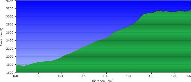
For the first mile, the route is a steep bulldozed logging road. During or immediately after heavy rains, this section would have a stream flowing down it or slippery mud in places. The upper section is a steep path winding through leaf covered rocks. Up on top of the ridge, the path is covered with pine needles.
Fees, Permits, etc.
This trail route is accessed through the property of Mary and Danes Faulkner, thus need to contact for permission.
After the Hike
Nothing at I-81 Exit 50, so you'll have to head to an area town for refreshment.
Misc. Information
There is another route to Chimney Top from the NW side, which is also on private property.
The Great Smoky Mountains National Park also has a Chimney Tops Trail (note plural) that is well known in the region. link
The property owner stated that rattlesnakes are common in the summer, which would have many rocks on the upper section to hide between. Colder weather may be a better time to enjoy this high. Mid-April just has some wildflowers beginning to bloom.
Maps
<googlemap version="0.9" lat="36.406" lon="-82.700" type="terrain" zoom="15" height="450" width="645" icons="http://tehcc.org/clubwiki/kml/marker{label}.png"> http://tehcc.org/clubwiki/kml/Chimney_Top.kml
(A) 36.40146,-82.69347 Parking at Faulkner's for Chimney Top (G) 36.40133,-82.69431 Trailhead by garage (M) 36.41037,-82.70278 airway beacon (G) 36.40817,-82.70697 Chimney Top highpoint at former firetower </googlemap>
- The profile shows the steep hike up until upon the ridge line.

