John Tomko Trail: Difference between revisions
(→Maps: Updating for new Maps extension) |
m (Remove incorrect hike log) Tag: Manual revert |
||
| (8 intermediate revisions by 4 users not shown) | |||
| Line 1: | Line 1: | ||
<!-- The following few lines create the "Infobox" table template. Please scroll down to edit the main content of the article. | <!-- The following few lines create the "Infobox" table template. Please scroll down to edit the main content of the article. | ||
<!-- | -->{{Infobox Trail | ||
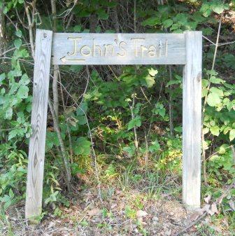
| Image Name = PRP_John_Tomko_trail_sign.JPG | |||
| Park = Persimmon Ridge Park | |||
| City = Jonesborough | |||
| State = Tennessee | |||
| Marking = Unknown | |||
| Trail Use = {{Hike}}{{Dogs}} | |||
| Difficulty Rating = Easy | |||
| Hike Time = 0.5 | |||
| Distance = 0.65 | |||
| Elevation Gain = 198 | |||
| High Point = 1977 | |||
| Latitude = 36.28825 | |||
| Longitude = -82.49837 | |||
| Medical = Johnson City, TN | |||
}}<!-- | |||
End Infobox template table | |||
-->{{Trail page needs | |||
| Hide needs = | |||
| KML = | |||
| Updated KML = | |||
| Detail route description = Yes | |||
| Photos = | |||
| Winter photos = | |||
| Remove prefix = Yes | |||
| Update infobox = Yes | |||
| Infobox data update = Yes | |||
| Trail pins = | |||
| Other = | |||
| Comment = | |||
| Date reviewed = 10/31/2015 | |||
}}<!-- | |||
Start of Main Page --> | |||
== Trail Overview == | == Trail Overview == | ||
<!-- Enter a overview of the trail. What attracts you to this trail, points of interest, types of flowers, lakes, and peaks that you see along the way. --> | <!-- Enter a overview of the trail. What attracts you to this trail, points of interest, types of flowers, lakes, and peaks that you see along the way. --> | ||
| Line 57: | Line 75: | ||
== Regulations == | == Regulations == | ||
No Bicycles | |||
-Hiking and Bushcraft welcome | |||
== Misc. Information == | == Misc. Information == | ||
| Line 67: | Line 86: | ||
John Tomko Trail is shown as yellow line below. Water Hopkins Trail is green. Luke Carter Trail is red. Gravel access roads in blue. | John Tomko Trail is shown as yellow line below. Water Hopkins Trail is green. Luke Carter Trail is red. Gravel access roads in blue. | ||
<display_map center="36.2875,-82.505" type="terrain" zoom="15" width="700" height="550" gkml=" | <display_map center="36.2875,-82.505" type="terrain" zoom="15" width="700" height="550" gkml="https://tehcc.org/clubwiki/kml/PRP_Luke_Carter_Trail.kml, | ||
https://tehcc.org/clubwiki/kml/PRP_Walter_Hopkins_Trail.kml, | |||
https://tehcc.org/clubwiki/kml/PRP_John_Tomko_Trail.kml, | |||
https://tehcc.org/clubwiki/kml/PRP_Gravel_Road.kml"> | |||
36.289343,-82.503302~Eastern trailhead~ ~MarkerG.png | 36.289343,-82.503302~Eastern trailhead~ ~MarkerG.png | ||
Latest revision as of 12:05, 19 May 2024
| |||||||||||||||||||||||||||||||||||||||
Trail Overview[edit]
Located in Persimmon Ridge Park. A ridgeline hike through second generation hardwoods with gap view at powerline down at Wetlands water park.
How to get there[edit]
Driving direction on main park page. Parking for the main trailhead is located at the ballfields. Follow the gravel roadway along Field #1 until it takes a sharp left turn. This is the access road to the water tower. John's trail is on right at a post which used to have a sign.
Route Description[edit]
| Miles | John Tomko Trail | Miles | Elevation |
|---|---|---|---|
| 0.0 | Eastern trailhead | 0.65 | 1781 |
| 0.45 | Intersect gravel road which heads to water tank | 0.20 | 1910 |
| 0.65 | Western trailhead up at water tank | 0.00 | 1971 |
Typical Conditions[edit]
Hard dirt trail. Missing signage at actual trail - would be great at gravel road. Someone has removed several blowdowns, but trail had to be slightly rerouted a four trunk pile. Also a weed trimmer might have been used to clear ground weeds. Lots of trimming needed today at shoulder level to have a readily passable path.
Regulations[edit]
No Bicycles -Hiking and Bushcraft welcome
Misc. Information[edit]
The trail is named after John Tomko, who led its construction for his Eagle Scout project. Might have been part of Boy Scout Troop 39 (to be confirmed).
Maps[edit]
John Tomko Trail is shown as yellow line below. Water Hopkins Trail is green. Luke Carter Trail is red. Gravel access roads in blue.


