|
|
| (5 intermediate revisions by 2 users not shown) |
| Line 1: |
Line 1: |
| <!-- The following few lines create the "Infobox" table template. Please scroll down to edit the main content of the article. --> | | <!-- The following few lines create the "Infobox" table template. Please scroll down to edit the main content of the article. |
| {{Infobox Trail
| |
| | Image Name = GSMNP_Porter_Creek.JPG
| |
| | City = Gatlinburg
| |
| | State = Tennessee
| |
| | Marking = None
| |
| | Trail Use = {{Hike}} {{Waterfall}}
| |
| | Difficulty Rating = Easy
| |
| | Hike Time = 2.5
| |
| | Distance = 4-5
| |
| | Elevation Gain = 735
| |
| | High Point = *
| |
| | Latitude = 35.69675
| |
| | Longitude = -83.38822
| |
| | Medical = Sevierville
| |
| }}
| |
| <!-- End Infobox template table-->
| |
|
| |
|
| <!-- Start of Main Page --> | | -->{{Infobox Trail |
| | | Image Name = GSMNP_Porter_Creek.JPG |
| | | Park = Great Smoky Mountains National Park |
| | | City = Gatlinburg |
| | | State = Tennessee |
| | | Marking = None |
| | | Trail Use = {{Hike}} {{Waterfall}} |
| | | Difficulty Rating = Easy |
| | | Hike Time = 2.5 Hours |
| | | Round Trip Distance = 3.74 Mi |
| | | Trail Distance = 1.87 Mi |
| | | Trail Type = In-and-Out |
| | | Elevation Gain = 1,021 Ft |
| | | Elevation Loss = -296 Ft |
| | | High Point = 6,635 Ft |
| | | Parking coords = 35.69675,-83.38822 |
| | | Trailhead coords = 35.69675,-83.38822 |
| | | Medical = Sevierville |
| | }}<!-- |
|
| |
|
| | End Infobox template table |
| | |
| | -->{{Trail page needs |
| | | Hide needs = |
| | | KML = |
| | | Updated KML = |
| | | Detail route description = Yes |
| | | Photos = |
| | | Winter photos = |
| | | Remove prefix = Yes |
| | | Update infobox = |
| | | Infobox data update = |
| | | Trail pins = |
| | | Other = |
| | | Comment = |
| | | Date reviewed = 10/25/2015 |
| | }}<!-- |
| | |
| | Start of Main Page --> |
| == Trail Overview == | | == Trail Overview == |
| <!-- Enter a overview of the trail. What attracts you to this trail, points of interest, types of flowers, lakes, and peaks that you see along the way. --> | | <!-- Enter a overview of the trail. What attracts you to this trail, points of interest, types of flowers, lakes, and peaks that you see along the way. --> |
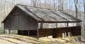
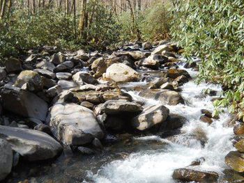
| An easy hike along a cascading stream to see wildflowers, settler's life, and small waterfall.
| | Located in the [[Great Smoky Mountains National Park]], an easy hike along a cascading stream to see wildflowers, settler's life, and small waterfall. |
|
| |
|
| == How to get there == | | == How to get there == |
| Line 57: |
Line 78: |
| |Fern Branch Falls | | |Fern Branch Falls |
| |} | | |} |
| | |
| | Continuing up the trail will reach backcountry Campsite #31 at 3.4 miles. |
|
| |
|
| == Typical Conditions == | | == Typical Conditions == |
| Line 76: |
Line 99: |
| <!-- You can place pictures, PDF's, links, or even create a Google map with your waypoints and place it here. --> | | <!-- You can place pictures, PDF's, links, or even create a Google map with your waypoints and place it here. --> |
| <!-- Ready for the KML to be uploaded --> | | <!-- Ready for the KML to be uploaded --> |
| <googlemap version="0.9" lat="35.687" lon="-83.39" type="terrain" zoom="14" width="750" scale="yes" controls="medium" icons="http://tehcc.org/clubwiki/kml/marker{label}.png"> | | <display_map center="35.687,-83.39" type="terrain" zoom="14" width="auto" gkml="https://tehcc.org/clubwiki/kml/GSMNP_Porter_Creek_Trail.kml"> |
| http://tehcc.org/clubwiki/kml/GSMNP_Porter_Creek_Trail.kml
| | |
| (A) 35.69675,-83.38822
| | 35.69675,-83.38822~Parking at trailhead gate~[[Image:GSMNP_Porter_Creek1.JPG|150px]]~MarkerA.png |
| Parking at trailhead gate | | 35.68958,-83.39615~Ownby Cemetery~ ~MarkerN.png |
| [[Image:GSMNP_Porter_Creek1.JPG|150px]] | | 35.,-83.~First trail bridge~ ~MarkerL.png |
| (N) 35.68958,-83.39615
| | 35.68747,-83.39928~Homestead~ ~MarkerV.png |
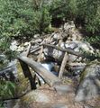
| Ownby Cemetery | | 35.68068,-83.39757~Trail bridge~[[Image:GSMNP_Porter_Creek2.JPG|150px]]~MarkerL.png |
| (L) 35.,-83.
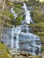
| | 35.67669,-83.39673~Fern Branch Falls~[[Image:GSMNP_Fern_Branch_Falls.JPG|150px|Fern Branch Falls]]~MarkerC.png |
| First trail bridge | | </display_map> |
| (G) 35.68747,-83.39928
| |
| Homestead | |
| (L) 35.68068,-83.39757
| |
| Trail bridge | |
| [[Image:GSMNP_Porter_Creek2.JPG|150px]] | |
| (C) 35.67669,-83.39673
| |
| Fern Branch Falls | |
| [[Image:GSMNP_Fern_Branch_Falls.JPG|150px|Fern Branch Falls]] | |
| </googlemap> | |
|
| |
|
| == Photos == | | == Photos == |
|
|
|
|
|
| Trail Name
|
GSMNP Porter Creek
|
| Park
|
Great Smoky Mountains National Park
|
| Nearest City
|
Gatlinburg
|
| State
|
Tennessee
|
| Trail Marking
|
None
|
| Trail Use/Features
|
 
|
| Difficulty Rating
|
Easy
|
| Hiking Time
|
2.5 Hours0.156 Days <br />150 Min <br />
|
Distance:
round-trip/trail only
|
3.74 Mi6.019 km <br /> / 1.87 Mi3.009 km <br />
|
| Trail Type
|
In-and-Out
|
| Climb/Descent Elevation
|
1,021 Ft311.201 Meters <br /> / -296 Ft-90.221 Meters <br />
|
| High Point
|
6,635 Ft2,211.667 Yards <br />2,022.348 Meters <br />
|
| Parking
|
35° 41' 48.30" N, 83° 23' 17.59" W
|
| Trailhead
|
35° 41' 48.30" N, 83° 23' 17.59" W
|
| Nearest Medical
|
Sevierville
|
| Trip Reports
|
Click Here
|
|
|
Loading map... {"type":"ROADMAP","minzoom":false,"maxzoom":false,"types":["ROADMAP","SATELLITE","HYBRID","TERRAIN"],"mappingservice":"googlemaps3","width":"270px","height":"180px","centre":false,"title":"","label":"","icon":"","lines":[],"polygons":[],"circles":[],"rectangles":[],"copycoords":false,"static":false,"visitedicon":"","wmsoverlay":false,"zoom":8,"layers":[],"controls":["zoom"],"zoomstyle":"DEFAULT","typestyle":"DEFAULT","autoinfowindows":false,"resizable":false,"kmlrezoom":false,"poi":true,"cluster":false,"clustergridsize":60,"clustermaxzoom":20,"clusterzoomonclick":true,"clusteraveragecenter":true,"clusterminsize":2,"imageoverlays":[],"kml":[],"gkml":[],"searchmarkers":"","fullscreen":false,"scrollwheelzoom":false,"locations":[{"text":"","title":"","link":"","lat":35.69675000000000153477230924181640148162841796875,"lon":-83.3882200000000040063241613097488880157470703125,"icon":""}]} |
|
| Show Large Map
|
|
Trail Overview[edit]
Located in the Great Smoky Mountains National Park, an easy hike along a cascading stream to see wildflowers, settler's life, and small waterfall.
How to get there[edit]
From Gatlinburg, TN:
- Take US321 North (actually heading east) out of town.
- Turn right into Great Smoky Mountains National Park at Greenbrier entrance.
- Travel just over five miles on road which changes from paved to gravel - passing the road bridge to left to GSMNP Ramsey Cascades.
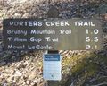
Trailhead starts at locked gate with brown information sign.
Route Description[edit]
The trail follows a gravel logging road at first, then continues uphill to follow the stream to the waterfall. At the farm site, make sure to take the far left "Porter Creek" trail along the stream versus the "Brushy Mtn." trail which leads towards GSMNP Grotto Falls in seven miles.
| Distance (mi)
|
Elevation (ft)
|
Description
|
| 0.0
|
XXXX
|
Trailhead
|
| 0.75
|
XXXX
|
Ownby Cemetery
|
| 1.0
|
XXXX
|
John Messer farm site
|
| 2.0
|
XXXX
|
Fern Branch Falls
|
Continuing up the trail will reach backcountry Campsite #31 at 3.4 miles.
Typical Conditions[edit]
National Park Service does trail maintenance primarily between May thru Nov, thus some blowdowns possible during the off-season. Gravel roadbed for first mile, changing to rocky footpath. The latter section can be muddy after a significant rain.
Fees, Permits, etc.[edit]
No fee. Per NPS policy, no mountain bikes or dogs (even if their owners cannot read the clearly posted signs).
After the Hike[edit]
Misc. Information[edit]
Be aware that black bears are in the area.
Loading map...
{"type":"TERRAIN","minzoom":false,"maxzoom":false,"types":["ROADMAP","SATELLITE","HYBRID","TERRAIN"],"mappingservice":"googlemaps3","width":"auto","height":"350px","centre":{"text":"","title":"","link":"","lat":35.6869999999999976125764078460633754730224609375,"lon":-83.3900000000000005684341886080801486968994140625,"icon":""},"title":"","label":"","icon":"","lines":[],"polygons":[],"circles":[],"rectangles":[],"copycoords":false,"static":false,"visitedicon":"","wmsoverlay":false,"zoom":14,"layers":[],"controls":["pan","zoom","type","scale","streetview","rotate"],"zoomstyle":"DEFAULT","typestyle":"DEFAULT","autoinfowindows":false,"resizable":false,"kmlrezoom":false,"poi":true,"cluster":false,"clustergridsize":60,"clustermaxzoom":20,"clusterzoomonclick":true,"clusteraveragecenter":true,"clusterminsize":2,"imageoverlays":[],"kml":[],"gkml":["https://tehcc.org/clubwiki/kml/GSMNP_Porter_Creek_Trail.kml"],"searchmarkers":"","fullscreen":false,"scrollwheelzoom":false,"locations":[{"text":"\u003Cb\u003E\u003Cdiv class=\"mw-parser-output\"\u003E\u003Cp\u003EParking at trailhead gate\n\u003C/p\u003E\u003C/div\u003E\u003C/b\u003E\u003Cdiv class=\"mw-parser-output\"\u003E\u003Cp\u003E\u003Ca href=\"/wiki/File:GSMNP_Porter_Creek1.JPG\" class=\"image\"\u003E\u003Cimg alt=\"GSMNP Porter Creek1.JPG\" src=\"/clubwiki/images/thumb/GSMNP_Porter_Creek1.JPG/150px-GSMNP_Porter_Creek1.JPG\" decoding=\"async\" width=\"150\" height=\"120\" srcset=\"/clubwiki/images/thumb/GSMNP_Porter_Creek1.JPG/225px-GSMNP_Porter_Creek1.JPG 1.5x, /clubwiki/images/thumb/GSMNP_Porter_Creek1.JPG/300px-GSMNP_Porter_Creek1.JPG 2x\" data-file-width=\"421\" data-file-height=\"336\" /\u003E\u003C/a\u003E\n\u003C/p\u003E\u003C/div\u003E","title":"Parking at trailhead gate\n","link":"","lat":35.69675000000000153477230924181640148162841796875,"lon":-83.3882200000000040063241613097488880157470703125,"icon":"/clubwiki/images/MarkerA.png"},{"text":"\u003Cdiv class=\"mw-parser-output\"\u003E\u003Cp\u003EOwnby Cemetery\n\u003C/p\u003E\u003C/div\u003E","title":"Ownby Cemetery\n","link":"","lat":35.68957999999999941564965411089360713958740234375,"lon":-83.396150000000005775291356258094310760498046875,"icon":"/clubwiki/images/MarkerN.png"},{"text":"\u003Cdiv class=\"mw-parser-output\"\u003E\u003Cp\u003EHomestead\n\u003C/p\u003E\u003C/div\u003E","title":"Homestead\n","link":"","lat":35.68746999999999758301783003844320774078369140625,"lon":-83.399280000000004520188667811453342437744140625,"icon":"/clubwiki/images/MarkerV.png"},{"text":"\u003Cb\u003E\u003Cdiv class=\"mw-parser-output\"\u003E\u003Cp\u003ETrail bridge\n\u003C/p\u003E\u003C/div\u003E\u003C/b\u003E\u003Cdiv class=\"mw-parser-output\"\u003E\u003Cp\u003E\u003Ca href=\"/wiki/File:GSMNP_Porter_Creek2.JPG\" class=\"image\"\u003E\u003Cimg alt=\"GSMNP Porter Creek2.JPG\" src=\"/clubwiki/images/thumb/GSMNP_Porter_Creek2.JPG/150px-GSMNP_Porter_Creek2.JPG\" decoding=\"async\" width=\"150\" height=\"163\" srcset=\"/clubwiki/images/thumb/GSMNP_Porter_Creek2.JPG/225px-GSMNP_Porter_Creek2.JPG 1.5x, /clubwiki/images/thumb/GSMNP_Porter_Creek2.JPG/300px-GSMNP_Porter_Creek2.JPG 2x\" data-file-width=\"336\" data-file-height=\"364\" /\u003E\u003C/a\u003E\n\u003C/p\u003E\u003C/div\u003E","title":"Trail bridge\n","link":"","lat":35.68068000000000239424480241723358631134033203125,"lon":-83.397570000000001755324774421751499176025390625,"icon":"/clubwiki/images/MarkerL.png"},{"text":"\u003Cb\u003E\u003Cdiv class=\"mw-parser-output\"\u003E\u003Cp\u003EFern Branch Falls\n\u003C/p\u003E\u003C/div\u003E\u003C/b\u003E\u003Cdiv class=\"mw-parser-output\"\u003E\u003Cp\u003E\u003Ca href=\"/wiki/File:GSMNP_Fern_Branch_Falls.JPG\" class=\"image\" title=\"Fern Branch Falls\"\u003E\u003Cimg alt=\"Fern Branch Falls\" src=\"/clubwiki/images/thumb/GSMNP_Fern_Branch_Falls.JPG/150px-GSMNP_Fern_Branch_Falls.JPG\" decoding=\"async\" width=\"150\" height=\"201\" srcset=\"/clubwiki/images/thumb/GSMNP_Fern_Branch_Falls.JPG/225px-GSMNP_Fern_Branch_Falls.JPG 1.5x, /clubwiki/images/thumb/GSMNP_Fern_Branch_Falls.JPG/300px-GSMNP_Fern_Branch_Falls.JPG 2x\" data-file-width=\"334\" data-file-height=\"448\" /\u003E\u003C/a\u003E\n\u003C/p\u003E\u003C/div\u003E","title":"Fern Branch Falls\n","link":"","lat":35.67669000000000067984728957526385784149169921875,"lon":-83.3967300000000051340975915081799030303955078125,"icon":"/clubwiki/images/MarkerC.png"}]}