Winged Deer Park: Difference between revisions
No edit summary |
m (Text replacement - "http://tehcc.org/clubwiki/" to "https://tehcc.org/clubwiki/") |
||
| (One intermediate revision by one other user not shown) | |||
| Line 1: | Line 1: | ||
Winged Deer Park, owned by Johnson City, was created in 1991 from the 200-acre farm donated by the J. Norton Arney family. Now a recreational and historical complex with softball fields, batting cage, disc golf course, hiking trails, early pioneer cabin, tree arboretum, fishing pier, and more. | Winged Deer Park, owned by Johnson City, was created in 1991 from the 200-acre farm donated by the J. Norton Arney family. Now a recreational and historical complex with softball fields, batting cage, disc golf course, hiking trails, early pioneer cabin, tree arboretum, fishing pier, and more. | ||
< | <display_map center="36.392097,-82.363" type="terrain" zoom="15" width="auto" height="550" gkml="https://tehcc.org/clubwiki/kml/Winged_Deer_Park.kml, | ||
https://tehcc.org/clubwiki/kml/Winged_Deer_Park2.kml"> | |||
36.39008,-82.360526 | 36.39008,-82.360526~Winged Deer Park | ||
36.39200, -82.36850~Disc Golf Parking Lot (Alt. Trailhead)~ ~MarkerA.png | |||
</display_map> | |||
Disc Golf Parking Lot (Alt. Trailhead) | |||
</ | |||
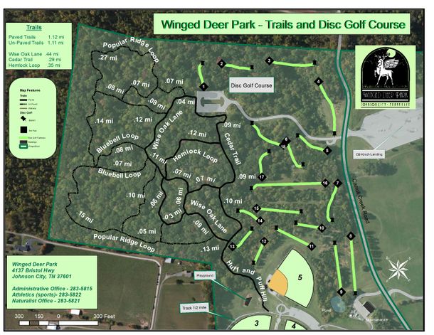
[[File:WingedDeer course and trails.jpg|610px]] | [[File:WingedDeer course and trails.jpg|610px]] | ||
Latest revision as of 12:12, 7 January 2023
Winged Deer Park, owned by Johnson City, was created in 1991 from the 200-acre farm donated by the J. Norton Arney family. Now a recreational and historical complex with softball fields, batting cage, disc golf course, hiking trails, early pioneer cabin, tree arboretum, fishing pier, and more.
How to get there[edit]
From Kingsport, TN
- Take I-26 south to Exit 19 (TN-381/State of Franklin Road).
- Veer left (north) at the bottom of the ramp towards Bristol.
- Keep left at the fork to head north onto US-11E/19W (Bristol Highway).
- Travel two miles until you see the soccer fields on the left.
- Turn into the main park entrance.
The old house is the park office, which will have trail maps (and a bathroom) available.
There is a second trail access parking lot. Pass main park entrances and turn left (west) on Carroll Creek Road. After only 0.3 miles, turn left at disc golf course sign.
Trails[edit]
The trails wander up, down, and around the wood lot of the former farm. The main attraction would be the various wildflowers in bloom or the many sinkholes and small caves. The walkways are popular with dog walkers. When the leaves are down a nice view of Holston Mountain is available. In early 2013, extensive chainsaw action was completed to drop many dead trees which are left along the paths.
The following trail segments are available in Winged Deer Park. Paved paths are asphalt, while unpaved are narrow single tracks. Maximum change in elevation within the park is a couple hundred feet.
| Trail | Miles | Blaze | Difficulty | Surface |
|---|---|---|---|---|
| Bluebell Loop | 0.15 | Easy | Unpaved | |
| Cedar Trail | 0.29 | Easy | Paved | |
| Hemlock Loop | 0.35 | Easy | Paved | |
| Huff and Puff Hill | 0.13 | Easy | Paved | |
| Poplar Ridge Loop | 0.81 | Easy | Unpaved | |
| Wise Oak Lane | 0.44 | Easy | Paved |
A grand loop hike of just 1.4 miles could explore the park in less than an hour by parking by the ball fields, and then taking Huff and Puff Hill to Poplar Ridge Loop to Cedar Trail and back.
