Table Rock Summit Trail
| Table Rock Summit Trail (log in to submit report) | |
|---|---|
| Highlight | Steep trail to top of spectacular cliffs overlooking Linville Gorge |
| Park | Linville Gorge Wilderness Area |
| Located | Linville, North CarolinaLocation inherited from associated park |
| Trail Marking | Unknown |
| Trail UseThings allowed to do on or near the trail | |
| FeaturesThings to see on or near the trail | |
| Difficulty Rating | Medium |
| Hiking TimeTime from car and back. Includes any time hiking to access this trail. | 1 hr0.0625 Days <br />60 Min <br /> round trip |
| Distance: | 0.3819 mi0.615 km <br /> trailStrict non-repeating trail length / 1.0 mi1.609 km <br /> round tripTypical or shortest length from the car, hike the trail, and return to car |
| Trail Type | In-and-Out |
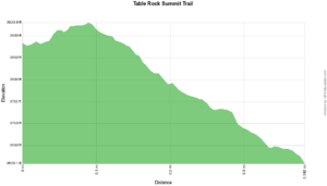
| Low / High Point | 3,609 ft1,203 Yards <br />1,100.023 Meters <br /> / 3,931 ft1,310.333 Yards <br />1,198.169 Meters <br /> |
| Elev. Gain/LossSee link for details of calculation. Gain/Loss is direction dependent. | 313 ft95.402 Meters <br /> / (-38 ft-11.582 Meters <br />) – West-to-East |
| Trip ReportsFrom user "hiked it" submissions<br />Recent is within last 90 days | 1 logged hikes (0 recent) |
| NearbyWithin 5 mi<br />Click link to view list | 1 trails / 0.9 mi of trail |
| Parking | 35° 53' 10.90" N, 81° 53' 4.74" W Map |
| Trailhead | 35° 53' 10.90" N, 81° 53' 4.74" W Map |
|
| |
| Show In Google Maps | |
Download KML / Upload new version / KML File Page / Create Profile Chart / gpsvisualizer Map
Trail Overview[edit]
Steep trail to top of spectacular cliffs overlooking Linville Gorge Wilderness area and much of western North Carolina
How to get there[edit]
From Elizabethton, TN:
- Turn onto US 19E/US 321 towards Hampton, TN.
- Continue straight on US 19E about 20 miles. (No turn - First NC 194 joins US 19E coming in from the left.)
- In a short distance, US 19E turns right and NC 194 continues straight. Go straight on NC 194 about 11 miles (through Newland, NC) to its junction with US 221.
- Turn left onto US 221 north for about 1 mile to Pineola, NC and junction with NC 181.
- Turn right on NC 181 and proceed south for about 8 miles. (No turn. Note mileage where NC 183 intersects.)
- About 3 miles south on NC 181 from the intersection with NC 183 turn right on the second intersection with Gingercake Road.
- In 0.3 miles take the left fork, Table Rock Road. Pavement ends in 0.9 miles and road is USFS 210.
The trailhead for Hawskbill Mtn. is on left, about 2 miles after pavement ends. There is a sign, parking is on the left. One mile farther on is the first trailhead for Table Rock Trail. It is signed for Spence Ridge Trail which descends into the gorge straight from the parking lot. Another mile farther is the second trailhead for Table Rock Trail.
First trailhead: The trail to Table Rock begins to the left of Spence Ridge Trail on an old road paralleling the road you came in but rising above it. Soon a clearing is reached where the trail continues roughly straight onto the blazed Mountain to Sea Trail which rises to the final summit trail to Table Rock which leads left. This trail is incredibly steep and about a mile or so to the fork that leads to the summit.
Second trailhead: This trail is much easier than the first. This trail meets at the same fork as first trailhead. Take fork to summit. Some rock scrambling required on trail to summit.
Route Description[edit]
First Trailhead: The Trail to Table Rock starts at the signed Spence Ridge Trail Head. Do not take Spence Ridge Trail. Rather take the trail on old road which parallels Table Rock Road and then turns right at the intersection with the Mountains to Sea Trail in about a quarter mile. Go right on the Mountains to Sea Trail for about a mile and take a very sharp switchback onto the Table Rock Summit Trail. There are a number of branches all leading to the top in a short distance. It is more confusing coming down but if you go the wrong way it will just take you back to the top.

