Loading map...
{"format":"googlemaps3","type":"TERRAIN","minzoom":false,"maxzoom":false,"types":["SATELLITE","HYBRID","TERRAIN"],"limit":50,"offset":0,"link":"none","sort":[""],"order":[],"headers":"show","mainlabel":"","intro":"","outro":"","searchlabel":"... further results","default":"","import-annotation":false,"width":"auto","height":"600px","centre":false,"title":"","label":"","icon":"","lines":[],"polygons":[],"circles":[],"rectangles":[],"copycoords":false,"static":false,"visitedicon":"","wmsoverlay":false,"zoom":false,"layers":[],"controls":["pan","zoom","type","scale","streetview","rotate"],"zoomstyle":"DEFAULT","typestyle":"DEFAULT","autoinfowindows":false,"resizable":false,"kmlrezoom":true,"poi":true,"cluster":false,"clustergridsize":60,"clustermaxzoom":20,"clusterzoomonclick":true,"clusteraveragecenter":true,"clusterminsize":2,"imageoverlays":[],"kml":[],"gkml":["https://tehcc.org/clubwiki/images/Squibb_Creek_Falls.kml"],"searchmarkers":"","fullscreen":false,"scrollwheelzoom":false,"showtitle":false,"hidenamespace":true,"template":"Map Balloon Template","userparam":"","activeicon":"","pagelabel":false,"ajaxcoordproperty":"","ajaxquery":"","locations":[{"text":"\u003Cp\u003E\u003Cb\u003E\u003Ca class=\"mw-selflink selflink\"\u003ESquibb Creek Falls\u003C/a\u003E\u003C/b\u003E\u003Cbr /\u003E\u003C/p\u003E\u003Chr /\u003E\u003Cp\u003E2.53\u0026#160;Mi (4.06\u0026#160;km)\u003Cbr /\u003EDifficulty: Medium\u003Cbr /\u003EMarking: None\u003C/p\u003E","title":"Squibb Creek Falls","link":"","lat":36.1056200000000018235368770547211170196533203125,"lon":-82.65408999999999650754034519195556640625,"icon":"/clubwiki/images/MarkerT.png"},{"text":"\u003Cp\u003E\u003Cb\u003EStream Crossing #8\u003C/b\u003E\u003Cbr /\u003E\u003C/p\u003E\u003Chr /\u003E\u003Cp\u003ETo Left Bank\u003C/p\u003E","title":"Squibb Creek Falls","link":"","lat":36.08803300000000291447577183134853839874267578125,"lon":-82.6363309999999984256646712310612201690673828125,"icon":"/clubwiki/images/MarkerJ.png"},{"text":"\u003Cp\u003E\u003Cb\u003EBridge\u003C/b\u003E\u003Cbr /\u003E\u003C/p\u003E\u003Chr /\u003E\u003Cp\u003EBridge\u003C/p\u003E","title":"Squibb Creek Falls","link":"","lat":36.10410999999999859255694900639355182647705078125,"lon":-82.64983200000000351792550645768642425537109375,"icon":"/clubwiki/images/MarkerL.png"},{"text":"\u003Cp\u003E\u003Cb\u003EStream Crossing #6\u003C/b\u003E\u003Cbr /\u003E\u003C/p\u003E\u003Chr /\u003E\u003Cp\u003ETo Left Bank\u003C/p\u003E","title":"Squibb Creek Falls","link":"","lat":36.08893499999999932015271042473614215850830078125,"lon":-82.6390659999999996898623066954314708709716796875,"icon":"/clubwiki/images/MarkerJ.png"},{"text":"\u003Cp\u003E\u003Cb\u003EPrivate Cabin\u003C/b\u003E\u003Cbr /\u003E\u003C/p\u003E\u003Chr /\u003E\u003Cp\u003EPrivate Cabin\u003C/p\u003E","title":"Squibb Creek Falls","link":"","lat":36.102767000000000052750692702829837799072265625,"lon":-82.6477210000000042100509745068848133087158203125,"icon":"/clubwiki/images/MarkerV.png"},{"text":"\u003Cp\u003E\u003Cb\u003EStream Crossing #9\u003C/b\u003E\u003Cbr /\u003E\u003C/p\u003E\u003Chr /\u003E\u003Cp\u003ETo Right Bank and small falls\u003C/p\u003E","title":"Squibb Creek Falls","link":"","lat":36.0876080000000030167939257808029651641845703125,"lon":-82.63591900000000123327481560409069061279296875,"icon":"/clubwiki/images/MarkerJ.png"},{"text":"\u003Cp\u003E\u003Cb\u003EStream Crossing #5\u003C/b\u003E\u003Cbr /\u003E\u003C/p\u003E\u003Chr /\u003E\u003Cp\u003ETo Right Bank\u003C/p\u003E","title":"Squibb Creek Falls","link":"","lat":36.09007199999999926376403891481459140777587890625,"lon":-82.6408480000000054133124649524688720703125,"icon":"/clubwiki/images/MarkerJ.png"},{"text":"\u003Cp\u003E\u003Cb\u003EBridge\u003C/b\u003E\u003Cbr /\u003E\u003C/p\u003E\u003Chr /\u003E\u003Cp\u003EBridge\u003C/p\u003E","title":"Squibb Creek Falls","link":"","lat":36.103982999999999492501956410706043243408203125,"lon":-82.653231000000005224137566983699798583984375,"icon":"/clubwiki/images/MarkerL.png"},{"text":"\u003Cp\u003E\u003Cb\u003EStream Crossing #12\u003C/b\u003E\u003Cbr /\u003E\u003C/p\u003E\u003Chr /\u003E\u003Cp\u003ETo Left Bank\u003C/p\u003E","title":"Squibb Creek Falls","link":"","lat":36.08654800000000051340975915081799030303955078125,"lon":-82.6349069999999983338057063519954681396484375,"icon":"/clubwiki/images/MarkerJ.png"},{"text":"\u003Cp\u003E\u003Cb\u003EStream Crossing #13\u003C/b\u003E\u003Cbr /\u003E\u003C/p\u003E\u003Chr /\u003E\u003Cp\u003ETo Right Bank\u003C/p\u003E","title":"Squibb Creek Falls","link":"","lat":36.08613199999999920919435680843889713287353515625,"lon":-82.6346769999999963829395710490643978118896484375,"icon":"/clubwiki/images/MarkerJ.png"},{"text":"\u003Cp\u003E\u003Cb\u003EStream Crossing #11\u003C/b\u003E\u003Cbr /\u003E\u003C/p\u003E\u003Chr /\u003E\u003Cp\u003ETo Right Bank\u003C/p\u003E","title":"Squibb Creek Falls","link":"","lat":36.08665599999999784586179885081946849822998046875,"lon":-82.6351140000000015106706996448338031768798828125,"icon":"/clubwiki/images/MarkerJ.png"},{"text":"\u003Cp\u003E\u003Cb\u003EStream Crossing #10\u003C/b\u003E\u003Cbr /\u003E\u003C/p\u003E\u003Chr /\u003E\u003Cp\u003ETo Left Bank\u003C/p\u003E","title":"Squibb Creek Falls","link":"","lat":36.08725100000000196587279788218438625335693359375,"lon":-82.635388000000006059053703211247920989990234375,"icon":"/clubwiki/images/MarkerJ.png"},{"text":"\u003Cp\u003E\u003Cb\u003EStream Crossing #1\u003C/b\u003E\u003Cbr /\u003E\u003C/p\u003E\u003Chr /\u003E\u003Cp\u003EStream Crossing #1\u003C/p\u003E","title":"Squibb Creek Falls","link":"","lat":36.10244200000000347472450812347233295440673828125,"lon":-82.647525000000001682565198279917240142822265625,"icon":"/clubwiki/images/MarkerJ.png"},{"text":"\u003Cp\u003E\u003Cb\u003EBridge\u003C/b\u003E\u003Cbr /\u003E\u003C/p\u003E\u003Chr /\u003E\u003Cp\u003EBridge\u003C/p\u003E","title":"Squibb Creek Falls","link":"","lat":36.10386700000000104182618088088929653167724609375,"lon":-82.6492520000000041591192712076008319854736328125,"icon":"/clubwiki/images/MarkerL.png"},{"text":"\u003Cp\u003E\u003Cb\u003EStream Crossing #2\u003C/b\u003E\u003Cbr /\u003E\u003C/p\u003E\u003Chr /\u003E\u003Cp\u003EStream Crossing #2\u003C/p\u003E","title":"Squibb Creek Falls","link":"","lat":36.10191300000000325098881148733198642730712890625,"lon":-82.6467339999999950350684230215847492218017578125,"icon":"/clubwiki/images/MarkerJ.png"},{"text":"\u003Cp\u003E\u003Cb\u003EStream Crossing #4\u003C/b\u003E\u003Cbr /\u003E\u003C/p\u003E\u003Chr /\u003E\u003Cp\u003EStream Crossing #4\u003C/p\u003E","title":"Squibb Creek Falls","link":"","lat":36.09378600000000147929313243366777896881103515625,"lon":-82.6430289999999985184331308118999004364013671875,"icon":"/clubwiki/images/MarkerJ.png"},{"text":"\u003Cp\u003E\u003Cb\u003EJunction with Turkey Pen Cove\u003C/b\u003E\u003Cbr /\u003E\u003C/p\u003E\u003Chr /\u003E\u003Cp\u003EJunction with Turkey Pen Cove\u003C/p\u003E","title":"Squibb Creek Falls","link":"","lat":36.10103199999999645797288394533097743988037109375,"lon":-82.64609699999999747888068668544292449951171875,"icon":"/clubwiki/images/MarkerG.png"},{"text":"\u003Cp\u003E\u003Cb\u003ESquibb Creek Falls\u003C/b\u003E\u003Cbr /\u003E\u003C/p\u003E\u003Chr /\u003E\u003Cp\u003ESquibb Creek Falls\u003C/p\u003E","title":"Squibb Creek Falls","link":"","lat":36.0853469999999987294359016232192516326904296875,"lon":-82.6337549999999936289896140806376934051513671875,"icon":"/clubwiki/images/MarkerC.png"},{"text":"\u003Cp\u003E\u003Cb\u003EStream Crossing #3\u003C/b\u003E\u003Cbr /\u003E\u003C/p\u003E\u003Chr /\u003E\u003Cp\u003EStream Crossing #3\u003C/p\u003E","title":"Squibb Creek Falls","link":"","lat":36.0969460000000026411726139485836029052734375,"lon":-82.6451200000000056888893595896661281585693359375,"icon":"/clubwiki/images/MarkerJ.png"},{"text":"\u003Cp\u003E\u003Cb\u003EJunction with Middlespring Ridge\u003C/b\u003E\u003Cbr /\u003E\u003C/p\u003E\u003Chr /\u003E\u003Cp\u003EJunction with Middlespring Ridge\u003C/p\u003E","title":"Squibb Creek Falls","link":"","lat":36.1002950000000026875568437390029430389404296875,"lon":-82.646129999999999427018337883055210113525390625,"icon":"/clubwiki/images/MarkerG.png"},{"text":"\u003Cp\u003E\u003Cb\u003EStream Crossing #7\u003C/b\u003E\u003Cbr /\u003E\u003C/p\u003E\u003Chr /\u003E\u003Cp\u003ETo Right Bank\u003C/p\u003E","title":"Squibb Creek Falls","link":"","lat":36.088121000000001004082150757312774658203125,"lon":-82.6365190000000069403540692292153835296630859375,"icon":"/clubwiki/images/MarkerJ.png"},{"text":"\u003Cp\u003E\u003Cb\u003EParking\u003C/b\u003E\u003Cbr /\u003E\u003C/p\u003E\u003Chr /\u003E\u003Cp\u003EParking\u003C/p\u003E","title":"Squibb Creek Falls","link":"","lat":36.10561500000000023646862246096134185791015625,"lon":-82.65408600000000660656951367855072021484375,"icon":"/clubwiki/images/MarkerA.png"},{"text":"\u003Cp\u003E\u003Cb\u003EPlatform overlooking creek\u003C/b\u003E\u003Cbr /\u003E\u003C/p\u003E\u003Chr /\u003E\u003Cp\u003EPlatform overlooking creek\u003C/p\u003E","title":"Squibb Creek Falls","link":"","lat":36.10544999999999760120772407390177249908447265625,"lon":-82.6534429999999957772160996682941913604736328125,"icon":"/clubwiki/images/MarkerE.png"}]}
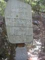
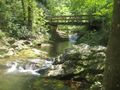
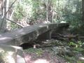
Park where the paved road ends and pass the wholly uninformative sign. The key to a proper beginning is to take the bridge on the left, just past the creek viewing platform. You should only be on the unpaved portion of Horse Creek Road for about 500ft.
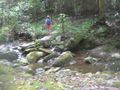
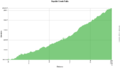
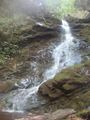
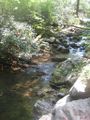
The hike mostly follows Squibb Creek upstream and therefore a mostly uphill hike to the falls. The average slope was recorded at 12.2% grade with a maximum grade of 62.5%. Although there are many stream crossings, in September they are easily navigable without risk of shoe soaking. The falls and stream crossings could be entirely different in the spring or after heavy rains. Also where needed along much of the route there are well built stone stairs.
None needed, just park and go.