John Tomko Trail
| |||||||||||||||||||||||||||||||||||||||

Trail Overview[edit]
Located in Persimmon Ridge Park. A ridgeline hike through second generation hardwoods with gap view at powerline down at Wetlands water park.
How to get there[edit]
Driving direction on main park page. Parking for the main trailhead is located at the ballfields. Follow the gravel roadway along Field #1 until it takes a sharp left turn. This is the access road to the water tower. John's trail is on right at a post which used to have a sign.
Route Description[edit]
| Miles | John Tomko Trail | Miles | Elevation |
|---|---|---|---|
| 0.0 | Eastern trailhead | 0.65 | 1781 |
| 0.45 | Intersect gravel road which heads to water tank | 0.20 | 1910 |
| 0.65 | Western trailhead up at water tank | 0.00 | 1971 |
Typical Conditions[edit]
Hard dirt trail. Missing signage at actual trail - would be great at gravel road. Someone has removed several blowdowns, but trail had to be slightly rerouted a four trunk pile. Also a weed trimmer might have been used to clear ground weeds. Lots of trimming needed today at shoulder level to have a readily passable path.
Regulations[edit]
No Bicycles -Hiking and Bushcraft welcome
Misc. Information[edit]
The trail is named after John Tomko, who led its construction for his Eagle Scout project. Might have been part of Boy Scout Troop 39 (to be confirmed).
Maps[edit]
John Tomko Trail is shown as yellow line below. Water Hopkins Trail is green. Luke Carter Trail is red. Gravel access roads in blue.
Photos[edit]
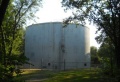
City water tank at top of trail
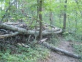
Trail diverted around blowdowns

