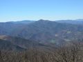
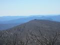
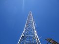
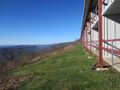
Mount Pisgah (5,722 ft.) is a very famous, easily recognizable landmark around most of western North Carolina especially the downtown Asheville area. Its distinct feature is its large WLOS antenna at the top so it’s very easy to pick out from the surrounding mountains. Its summit has 360 degree views if you don’t mind the antenna blocking some of it. This is one of the most popular hikes on the Blue Ridge Parkway and is usually crowded.
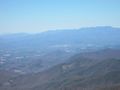
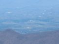
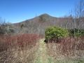
On clear days you can see downtown Asheville and the Biltmore House. Also you get views of the Craggy Mountains and Black Mountains. Cold Mountain and the Great Smoky Mountains National Park are also visible.
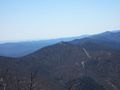
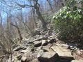
Very rugged rocky trail. Gets steep once you arrive at the ridgeline until the top
Loading map...
{"type":"TERRAIN","minzoom":false,"maxzoom":false,"types":["ROADMAP","SATELLITE","HYBRID","TERRAIN"],"mappingservice":"googlemaps3","width":"auto","height":"600px","centre":false,"title":"","label":"","icon":"","lines":[],"polygons":[],"circles":[],"rectangles":[],"copycoords":false,"static":false,"visitedicon":"","wmsoverlay":false,"zoom":false,"layers":[],"controls":["pan","zoom","type","scale","streetview","rotate"],"zoomstyle":"DEFAULT","typestyle":"DEFAULT","autoinfowindows":false,"resizable":false,"kmlrezoom":false,"poi":true,"cluster":false,"clustergridsize":60,"clustermaxzoom":20,"clusterzoomonclick":true,"clusteraveragecenter":true,"clusterminsize":2,"imageoverlays":[],"kml":[],"gkml":["https://tehcc.org/clubwiki/kml/PRD_Mount_Pisgah.kml"],"searchmarkers":"","fullscreen":false,"scrollwheelzoom":false,"locations":[{"text":"\u003Cb\u003E\u003Cdiv class=\"mw-parser-output\"\u003E\u003Cp\u003EBig Bald (5,286 ft)\n\u003C/p\u003E\u003C/div\u003E\u003C/b\u003E\u003Cdiv class=\"mw-parser-output\"\u003E\u003Cp\u003E\u003Ca href=\"/wiki/File:PRD_Mount_Pisgah_View_Big_Bald_Summit.jpg\" class=\"image\"\u003E\u003Cimg alt=\"PRD Mount Pisgah View Big Bald Summit.jpg\" src=\"/clubwiki/images/thumb/PRD_Mount_Pisgah_View_Big_Bald_Summit.jpg/150px-PRD_Mount_Pisgah_View_Big_Bald_Summit.jpg\" decoding=\"async\" width=\"150\" height=\"113\" srcset=\"/clubwiki/images/thumb/PRD_Mount_Pisgah_View_Big_Bald_Summit.jpg/225px-PRD_Mount_Pisgah_View_Big_Bald_Summit.jpg 1.5x, /clubwiki/images/thumb/PRD_Mount_Pisgah_View_Big_Bald_Summit.jpg/300px-PRD_Mount_Pisgah_View_Big_Bald_Summit.jpg 2x\" data-file-width=\"1200\" data-file-height=\"900\" /\u003E\u003C/a\u003E\n\u003C/p\u003E\u003C/div\u003E","title":"Big Bald (5,286 ft)\n","link":"","lat":35.39814926140000039822552935220301151275634765625,"lon":-82.7627128870000063898260123096406459808349609375,"icon":"/clubwiki/images/MarkerP.png"},{"text":"\u003Cb\u003E\u003Cdiv class=\"mw-parser-output\"\u003E\u003Cp\u003EBuck Springs Lodge Site\n\u003C/p\u003E\u003C/div\u003E\u003C/b\u003E\u003Cdiv class=\"mw-parser-output\"\u003E\u003Cp\u003E\u003Ca href=\"/wiki/File:PRD_Buck_Springs_Lodge.jpg\" class=\"image\"\u003E\u003Cimg alt=\"PRD Buck Springs Lodge.jpg\" src=\"/clubwiki/images/thumb/PRD_Buck_Springs_Lodge.jpg/150px-PRD_Buck_Springs_Lodge.jpg\" decoding=\"async\" width=\"150\" height=\"113\" srcset=\"/clubwiki/images/thumb/PRD_Buck_Springs_Lodge.jpg/225px-PRD_Buck_Springs_Lodge.jpg 1.5x, /clubwiki/images/thumb/PRD_Buck_Springs_Lodge.jpg/300px-PRD_Buck_Springs_Lodge.jpg 2x\" data-file-width=\"1200\" data-file-height=\"900\" /\u003E\u003C/a\u003E\n\u003C/p\u003E\u003C/div\u003E","title":"Buck Springs Lodge Site\n","link":"","lat":35.41377202009999791698646731674671173095703125,"lon":-82.7490075049999944667433737777173519134521484375,"icon":"/clubwiki/images/MarkerV.png"},{"text":"\u003Cb\u003E\u003Cdiv class=\"mw-parser-output\"\u003E\u003Cp\u003EFryingpan Mountain (5,326 ft)\n\u003C/p\u003E\u003C/div\u003E\u003C/b\u003E\u003Cdiv class=\"mw-parser-output\"\u003E\u003Cp\u003E\u003Ca href=\"/wiki/File:PRD_Mount_Pisgah_View_Fryingpan_Mountain.jpg\" class=\"image\"\u003E\u003Cimg alt=\"PRD Mount Pisgah View Fryingpan Mountain.jpg\" src=\"/clubwiki/images/thumb/PRD_Mount_Pisgah_View_Fryingpan_Mountain.jpg/150px-PRD_Mount_Pisgah_View_Fryingpan_Mountain.jpg\" decoding=\"async\" width=\"150\" height=\"113\" srcset=\"/clubwiki/images/thumb/PRD_Mount_Pisgah_View_Fryingpan_Mountain.jpg/225px-PRD_Mount_Pisgah_View_Fryingpan_Mountain.jpg 1.5x, /clubwiki/images/thumb/PRD_Mount_Pisgah_View_Fryingpan_Mountain.jpg/300px-PRD_Mount_Pisgah_View_Fryingpan_Mountain.jpg 2x\" data-file-width=\"1200\" data-file-height=\"900\" /\u003E\u003C/a\u003E\n\u003C/p\u003E\u003C/div\u003E","title":"Fryingpan Mountain (5,326 ft)\n","link":"","lat":35.39332631559999953196893329732120037078857421875,"lon":-82.774593199999998205385054461658000946044921875,"icon":"/clubwiki/images/MarkerP.png"},{"text":"\u003Cb\u003E\u003Cdiv class=\"mw-parser-output\"\u003E\u003Cp\u003EFryingpan Mountain Fire Tower\n\u003C/p\u003E\u003C/div\u003E\u003C/b\u003E\u003Cdiv class=\"mw-parser-output\"\u003E\u003Cp\u003E\u003Ca href=\"/wiki/File:PRD_Fryingpan_Mountain_Fire_Tower.jpg\" class=\"image\"\u003E\u003Cimg alt=\"PRD Fryingpan Mountain Fire Tower.jpg\" src=\"/clubwiki/images/thumb/PRD_Fryingpan_Mountain_Fire_Tower.jpg/150px-PRD_Fryingpan_Mountain_Fire_Tower.jpg\" decoding=\"async\" width=\"150\" height=\"113\" srcset=\"/clubwiki/images/thumb/PRD_Fryingpan_Mountain_Fire_Tower.jpg/225px-PRD_Fryingpan_Mountain_Fire_Tower.jpg 1.5x, /clubwiki/images/thumb/PRD_Fryingpan_Mountain_Fire_Tower.jpg/300px-PRD_Fryingpan_Mountain_Fire_Tower.jpg 2x\" data-file-width=\"1200\" data-file-height=\"900\" /\u003E\u003C/a\u003E\n\u003C/p\u003E\u003C/div\u003E","title":"Fryingpan Mountain Fire Tower\n","link":"","lat":35.39329971240000105581202660687267780303955078125,"lon":-82.774704705000004878456820733845233917236328125,"icon":"/clubwiki/images/Marker2.png"},{"text":"\u003Cdiv class=\"mw-parser-output\"\u003E\u003Cp\u003ELittle Bald Mountain (5,300 ft)\n\u003C/p\u003E\u003C/div\u003E","title":"Little Bald Mountain (5,300 ft)\n","link":"","lat":35.4072000000000031150193535722792148590087890625,"lon":-82.7459999999999951114659779705107212066650390625,"icon":"/clubwiki/images/MarkerP.png"},{"text":"\u003Cdiv class=\"mw-parser-output\"\u003E\u003Cp\u003ELittle Pisgah Mountain (5,288 ft)\n\u003C/p\u003E\u003C/div\u003E","title":"Little Pisgah Mountain (5,288 ft)\n","link":"","lat":35.423113802599999644371564500033855438232421875,"lon":-82.7450115569999979925341904163360595703125,"icon":"/clubwiki/images/MarkerP.png"},{"text":"\u003Cb\u003E\u003Cdiv class=\"mw-parser-output\"\u003E\u003Cp\u003EMount Pisgah (5,724 ft)\n\u003C/p\u003E\u003C/div\u003E\u003C/b\u003E\u003Cdiv class=\"mw-parser-output\"\u003E\u003Cp\u003E\u003Ca href=\"/wiki/File:PRD_Mount_Pisgah_Summit.jpg\" class=\"image\"\u003E\u003Cimg alt=\"PRD Mount Pisgah Summit.jpg\" src=\"/clubwiki/images/thumb/PRD_Mount_Pisgah_Summit.jpg/150px-PRD_Mount_Pisgah_Summit.jpg\" decoding=\"async\" width=\"150\" height=\"113\" srcset=\"/clubwiki/images/thumb/PRD_Mount_Pisgah_Summit.jpg/225px-PRD_Mount_Pisgah_Summit.jpg 1.5x, /clubwiki/images/thumb/PRD_Mount_Pisgah_Summit.jpg/300px-PRD_Mount_Pisgah_Summit.jpg 2x\" data-file-width=\"1200\" data-file-height=\"900\" /\u003E\u003C/a\u003E\n\u003C/p\u003E\u003C/div\u003E","title":"Mount Pisgah (5,724 ft)\n","link":"","lat":35.425702156200003400954301469027996063232421875,"lon":-82.7568295189999929561963654123246669769287109375,"icon":"/clubwiki/images/MarkerP.png"},{"text":"\u003Cdiv class=\"mw-parser-output\"\u003E\u003Cp\u003EMount Pisgah Campground\n\u003C/p\u003E\u003C/div\u003E","title":"Mount Pisgah Campground\n","link":"","lat":35.40277999999999991587174008600413799285888671875,"lon":-82.7566699999999997316990629769861698150634765625,"icon":"/clubwiki/images/MarkerH.png"},{"text":"\u003Cdiv class=\"mw-parser-output\"\u003E\u003Cp\u003EParking\n\u003C/p\u003E\u003C/div\u003E","title":"Parking\n","link":"","lat":35.39523598400000281571919913403689861297607421875,"lon":-82.76855328400000644251122139394283294677734375,"icon":"/clubwiki/images/MarkerA.png"},{"text":"\u003Cb\u003E\u003Cdiv class=\"mw-parser-output\"\u003E\u003Cp\u003EParking\n\u003C/p\u003E\u003C/div\u003E\u003C/b\u003E\u003Cdiv class=\"mw-parser-output\"\u003E\u003Cp\u003E\u003Ca href=\"/wiki/File:PRD_Mount_Pisgah_Parking_Lot.jpg\" class=\"image\"\u003E\u003Cimg alt=\"PRD Mount Pisgah Parking Lot.jpg\" src=\"/clubwiki/images/thumb/PRD_Mount_Pisgah_Parking_Lot.jpg/150px-PRD_Mount_Pisgah_Parking_Lot.jpg\" decoding=\"async\" width=\"150\" height=\"113\" srcset=\"/clubwiki/images/thumb/PRD_Mount_Pisgah_Parking_Lot.jpg/225px-PRD_Mount_Pisgah_Parking_Lot.jpg 1.5x, /clubwiki/images/thumb/PRD_Mount_Pisgah_Parking_Lot.jpg/300px-PRD_Mount_Pisgah_Parking_Lot.jpg 2x\" data-file-width=\"1200\" data-file-height=\"900\" /\u003E\u003C/a\u003E\n\u003C/p\u003E\u003C/div\u003E","title":"Parking\n","link":"","lat":35.41823244790000302373300655744969844818115234375,"lon":-82.7479353220000035662451409734785556793212890625,"icon":"/clubwiki/images/MarkerA.png"},{"text":"\u003Cb\u003E\u003Cdiv class=\"mw-parser-output\"\u003E\u003Cp\u003EPisgah Inn\n\u003C/p\u003E\u003C/div\u003E\u003C/b\u003E\u003Cdiv class=\"mw-parser-output\"\u003E\u003Cp\u003E\u003Ca href=\"/wiki/File:PRD_Pisgah_Inn.jpg\" class=\"image\"\u003E\u003Cimg alt=\"PRD Pisgah Inn.jpg\" src=\"/clubwiki/images/thumb/PRD_Pisgah_Inn.jpg/150px-PRD_Pisgah_Inn.jpg\" decoding=\"async\" width=\"150\" height=\"113\" srcset=\"/clubwiki/images/thumb/PRD_Pisgah_Inn.jpg/225px-PRD_Pisgah_Inn.jpg 1.5x, /clubwiki/images/thumb/PRD_Pisgah_Inn.jpg/300px-PRD_Pisgah_Inn.jpg 2x\" data-file-width=\"1200\" data-file-height=\"900\" /\u003E\u003C/a\u003E\n\u003C/p\u003E\u003C/div\u003E","title":"Pisgah Inn\n","link":"","lat":35.4029561701999995193546055816113948822021484375,"lon":-82.7536954440000016575140762142837047576904296875,"icon":"/clubwiki/images/MarkerG.png"},{"text":"\u003Cb\u003E\u003Cdiv class=\"mw-parser-output\"\u003E\u003Cp\u003EViewing Platform\n\u003C/p\u003E\u003C/div\u003E\u003C/b\u003E\u003Cdiv class=\"mw-parser-output\"\u003E\u003Cp\u003E\u003Ca href=\"/wiki/File:PRD_Mount_Pisgah_Platform.jpg\" class=\"image\"\u003E\u003Cimg alt=\"PRD Mount Pisgah Platform.jpg\" src=\"/clubwiki/images/thumb/PRD_Mount_Pisgah_Platform.jpg/150px-PRD_Mount_Pisgah_Platform.jpg\" decoding=\"async\" width=\"150\" height=\"113\" srcset=\"/clubwiki/images/thumb/PRD_Mount_Pisgah_Platform.jpg/225px-PRD_Mount_Pisgah_Platform.jpg 1.5x, /clubwiki/images/thumb/PRD_Mount_Pisgah_Platform.jpg/300px-PRD_Mount_Pisgah_Platform.jpg 2x\" data-file-width=\"1200\" data-file-height=\"900\" /\u003E\u003C/a\u003E\n\u003C/p\u003E\u003C/div\u003E","title":"Viewing Platform\n","link":"","lat":35.425588541899998062945087440311908721923828125,"lon":-82.7567871680000024525725166313350200653076171875,"icon":"/clubwiki/images/MarkerG.png"}]}