|
|
|
|
|
| Trail Name
|
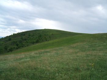
Max Patch
|
| Nearest City
|
Madison County
|
| State
|
North Carolina
|
| Trail Marking
|
|
| Trail Use/Features
|

|
| Difficulty Rating
|
Easy
|
| Hiking Time
|
22 Hours <br />0.125 Days <br />120 Min <br />
|
| Distance, round-trip
|
2.62.6 mi <br />4.184 km <br />
|
| Climb/Descent Elevation
|
350350 Feet <br />106.68 Meters <br /> / {{{Elevation Loss}}}"{{{Elevation Loss}}}" is not a number.
|
| High Point
|
46294,629 Feet <br />1,543 Yards <br />1,410.919 Meters <br />
|
| Nearest Medical
|
Newport, TN
|
| Trip Reports
|
Click Here
|
|
|
Loading map... {"type":"ROADMAP","minzoom":false,"maxzoom":false,"types":["ROADMAP","SATELLITE","HYBRID","TERRAIN"],"mappingservice":"googlemaps3","width":"270px","height":"180px","centre":false,"title":"","label":"","icon":"","lines":[],"polygons":[],"circles":[],"rectangles":[],"copycoords":false,"static":false,"visitedicon":"","wmsoverlay":false,"zoom":8,"layers":[],"controls":["zoom"],"zoomstyle":"DEFAULT","typestyle":"DEFAULT","autoinfowindows":false,"resizable":false,"kmlrezoom":false,"poi":true,"cluster":false,"clustergridsize":60,"clustermaxzoom":20,"clusterzoomonclick":true,"clusteraveragecenter":true,"clusterminsize":2,"imageoverlays":[],"kml":[],"gkml":[],"searchmarkers":"","fullscreen":false,"scrollwheelzoom":false,"locations":[{"text":"","title":"","link":"","lat":35.7970499999999987039700499735772609710693359375,"lon":-82.9568100000000043792169890366494655609130859375,"icon":""}]} |
|
| Show Large Map
|
|
Trail Overview[edit]
Hike to open 300-acre bald with a full 360 degree view – bring a lunch to enjoy. There are longer ways to reach Max Patch, but this hike is the shortest walk; however all require several miles driving on winding gravel roads.
How to get there[edit]
From Kingsport, TN - by interstates (2 ¼ hours)
- Head south on I-26 and then east on I-40 into North Carolina. (~100 miles)
- Take Exit 7 (Harmon Den).
- Turn left at end of exit ramp onto gravel Cold Springs Creek Road.
- After 3.6 miles, take left onto gravel Fall Branch Road.
- After another 2.4 miles, turn left onto Max Patch Road.
- Reach parking area in a couple of miles.
Note: This route is 8 miles on a winding gravel road!
Or cross-country (2 hours, but more winding road)
- Head to Greeneville by your favorite route – TN93 or TN172
- Next choice: Get to Del Rio either by US321 to Parrottsville and south on TN340/US70 –or- TN107 around to US70. Very similar distance and driving time.
- Continue south on TN107 for six miles.
- Take left onto Round Mountain Road for 7.4 very winding miles while entering North Carolina.
- Veer right/west to proceed on Max Patch Road just over three miles.
- Reach parking area.
Route Description[edit]
Best done in the clockwise direction, so that the steepest slopes are downhill during the return. Cross sty in fence to follow well-worn path around and up to the bald. Continue loop to return to parking.
Typical Conditions[edit]
Great leaf color, but also busiest in the fall. Remember that it will be 10-15°F cooler up on the bald than down in the towns, so bring layers. Also avoid the bald in inclement weather due to lightning strikes!
From the information for the benchmark on Max Patch, it references that there used to be an airport up on the bald. The Forest Service now has to mow the bald to keep it open.
Vandals riding ATVs did significant damage to Max Patch in December 2012 and January 2013. Fortunately, they have been caught. A land management plan is being created to provide more permanent barricades.
Fees, Permits, etc.[edit]
Free. However, no camping or fires permitted on Max Patch. Those hiking the AT will need to go farther to reach acceptable camping spots.
After the Hike[edit]
Misc. Information[edit]
See also Hump Mountain farther north on the AT for a similar 360 degree view bald.
Loading map...
{"type":"TERRAIN","minzoom":false,"maxzoom":false,"types":["ROADMAP","SATELLITE","HYBRID","TERRAIN"],"mappingservice":"googlemaps3","width":"auto","height":"350px","centre":{"text":"","title":"","link":"","lat":35.7970499999999987039700499735772609710693359375,"lon":-82.9568100000000043792169890366494655609130859375,"icon":""},"title":"","label":"","icon":"","lines":[],"polygons":[],"circles":[],"rectangles":[],"copycoords":false,"static":false,"visitedicon":"","wmsoverlay":false,"zoom":14,"layers":[],"controls":["pan","zoom","type","scale","streetview","rotate"],"zoomstyle":"DEFAULT","typestyle":"DEFAULT","autoinfowindows":false,"resizable":false,"kmlrezoom":false,"poi":true,"cluster":false,"clustergridsize":60,"clustermaxzoom":20,"clusterzoomonclick":true,"clusteraveragecenter":true,"clusterminsize":2,"imageoverlays":[],"kml":[],"gkml":["https://tehcc.org/clubwiki/kml/Appalachian_Trail_TNEastman_Section.kml"],"searchmarkers":"","fullscreen":false,"scrollwheelzoom":false,"locations":[{"text":"\u003Cdiv class=\"mw-parser-output\"\u003E\u003Cp\u003EParking lot\n\u003C/p\u003E\u003C/div\u003E","title":"Parking lot\n","link":"","lat":35.79635600000000295040081255137920379638671875,"lon":-82.9626540000000005647962098009884357452392578125,"icon":"/clubwiki/images/MarkerA.png"},{"text":"\u003Cdiv class=\"mw-parser-output\"\u003E\u003Cp\u003EMax Patch\n\u003C/p\u003E\u003C/div\u003E","title":"Max Patch\n","link":"","lat":35.7970499999999987039700499735772609710693359375,"lon":-82.9568100000000043792169890366494655609130859375,"icon":"/clubwiki/images/MarkerG.png"}]}

