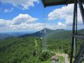
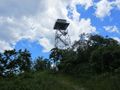
Fryingpan Mountain (5,340 ft.) is in the Pisgah Ranger District southwest of Asheville NC. It's noticeable feature is a 70ft fire tower on its summit. It is the tallest fire tower in the entire state of North Carolina.
The cab of the fire tower is locked but you can take the old metal stairs to just below it and get stunning 360 degree views. There are communication towers on the summit as well but they don't really interfere with the view.
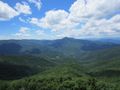
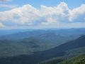
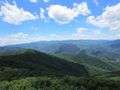
The fire tower has views of the entire Balsam Mountains range. It has a close-up view of famous Cold Mountain which is just a mere 5 miles north. Looking Glass Rock and Mount Pisgah are not that far away either. The Great Smoky Mountains National Park is visible as well.
You park at the entrance to the Forest Service Road 450, at Milepost 409.6 on the Blue Ridge Parkway. Do not block the road or the gate. Just walk up the .75 mile gravel road to the summit.
Loading map...
{"type":"TERRAIN","minzoom":false,"maxzoom":false,"types":["ROADMAP","SATELLITE","HYBRID","TERRAIN"],"mappingservice":"googlemaps3","width":"auto","height":"600px","centre":false,"title":"","label":"","icon":"","lines":[],"polygons":[],"circles":[],"rectangles":[],"copycoords":false,"static":false,"visitedicon":"","wmsoverlay":false,"zoom":false,"layers":[],"controls":["pan","zoom","type","scale","streetview","rotate"],"zoomstyle":"DEFAULT","typestyle":"DEFAULT","autoinfowindows":false,"resizable":false,"kmlrezoom":false,"poi":true,"cluster":false,"clustergridsize":60,"clustermaxzoom":20,"clusterzoomonclick":true,"clusteraveragecenter":true,"clusterminsize":2,"imageoverlays":[],"kml":[],"gkml":["https://tehcc.org/clubwiki/kml/PRD_Fryingpan_Mountain.kml"],"searchmarkers":"","fullscreen":false,"scrollwheelzoom":false,"locations":[{"text":"\u003Cb\u003E\u003Cdiv class=\"mw-parser-output\"\u003E\u003Cp\u003EBig Bald (5,286 ft)\n\u003C/p\u003E\u003C/div\u003E\u003C/b\u003E\u003Cdiv class=\"mw-parser-output\"\u003E\u003Cp\u003E\u003Ca href=\"/wiki/File:PRD_Mount_Pisgah_View_Big_Bald_Summit.jpg\" class=\"image\"\u003E\u003Cimg alt=\"PRD Mount Pisgah View Big Bald Summit.jpg\" src=\"/clubwiki/images/thumb/PRD_Mount_Pisgah_View_Big_Bald_Summit.jpg/150px-PRD_Mount_Pisgah_View_Big_Bald_Summit.jpg\" decoding=\"async\" width=\"150\" height=\"113\" srcset=\"/clubwiki/images/thumb/PRD_Mount_Pisgah_View_Big_Bald_Summit.jpg/225px-PRD_Mount_Pisgah_View_Big_Bald_Summit.jpg 1.5x, /clubwiki/images/thumb/PRD_Mount_Pisgah_View_Big_Bald_Summit.jpg/300px-PRD_Mount_Pisgah_View_Big_Bald_Summit.jpg 2x\" data-file-width=\"1200\" data-file-height=\"900\" /\u003E\u003C/a\u003E\n\u003C/p\u003E\u003C/div\u003E","title":"Big Bald (5,286 ft)\n","link":"","lat":35.39814926140000039822552935220301151275634765625,"lon":-82.7627128870000063898260123096406459808349609375,"icon":"/clubwiki/images/MarkerP.png"},{"text":"\u003Cb\u003E\u003Cdiv class=\"mw-parser-output\"\u003E\u003Cp\u003EBuck Springs Lodge Site\n\u003C/p\u003E\u003C/div\u003E\u003C/b\u003E\u003Cdiv class=\"mw-parser-output\"\u003E\u003Cp\u003E\u003Ca href=\"/wiki/File:PRD_Buck_Springs_Lodge.jpg\" class=\"image\"\u003E\u003Cimg alt=\"PRD Buck Springs Lodge.jpg\" src=\"/clubwiki/images/thumb/PRD_Buck_Springs_Lodge.jpg/150px-PRD_Buck_Springs_Lodge.jpg\" decoding=\"async\" width=\"150\" height=\"113\" srcset=\"/clubwiki/images/thumb/PRD_Buck_Springs_Lodge.jpg/225px-PRD_Buck_Springs_Lodge.jpg 1.5x, /clubwiki/images/thumb/PRD_Buck_Springs_Lodge.jpg/300px-PRD_Buck_Springs_Lodge.jpg 2x\" data-file-width=\"1200\" data-file-height=\"900\" /\u003E\u003C/a\u003E\n\u003C/p\u003E\u003C/div\u003E","title":"Buck Springs Lodge Site\n","link":"","lat":35.41377202009999791698646731674671173095703125,"lon":-82.7490075049999944667433737777173519134521484375,"icon":"/clubwiki/images/MarkerV.png"},{"text":"\u003Cb\u003E\u003Cdiv class=\"mw-parser-output\"\u003E\u003Cp\u003EFryingpan Mountain (5,326 ft)\n\u003C/p\u003E\u003C/div\u003E\u003C/b\u003E\u003Cdiv class=\"mw-parser-output\"\u003E\u003Cp\u003E\u003Ca href=\"/wiki/File:PRD_Mount_Pisgah_View_Fryingpan_Mountain.jpg\" class=\"image\"\u003E\u003Cimg alt=\"PRD Mount Pisgah View Fryingpan Mountain.jpg\" src=\"/clubwiki/images/thumb/PRD_Mount_Pisgah_View_Fryingpan_Mountain.jpg/150px-PRD_Mount_Pisgah_View_Fryingpan_Mountain.jpg\" decoding=\"async\" width=\"150\" height=\"113\" srcset=\"/clubwiki/images/thumb/PRD_Mount_Pisgah_View_Fryingpan_Mountain.jpg/225px-PRD_Mount_Pisgah_View_Fryingpan_Mountain.jpg 1.5x, /clubwiki/images/thumb/PRD_Mount_Pisgah_View_Fryingpan_Mountain.jpg/300px-PRD_Mount_Pisgah_View_Fryingpan_Mountain.jpg 2x\" data-file-width=\"1200\" data-file-height=\"900\" /\u003E\u003C/a\u003E\n\u003C/p\u003E\u003C/div\u003E","title":"Fryingpan Mountain (5,326 ft)\n","link":"","lat":35.39332631559999953196893329732120037078857421875,"lon":-82.774593199999998205385054461658000946044921875,"icon":"/clubwiki/images/MarkerP.png"},{"text":"\u003Cb\u003E\u003Cdiv class=\"mw-parser-output\"\u003E\u003Cp\u003EFryingpan Mountain Fire Tower\n\u003C/p\u003E\u003C/div\u003E\u003C/b\u003E\u003Cdiv class=\"mw-parser-output\"\u003E\u003Cp\u003E\u003Ca href=\"/wiki/File:PRD_Fryingpan_Mountain_Fire_Tower.jpg\" class=\"image\"\u003E\u003Cimg alt=\"PRD Fryingpan Mountain Fire Tower.jpg\" src=\"/clubwiki/images/thumb/PRD_Fryingpan_Mountain_Fire_Tower.jpg/150px-PRD_Fryingpan_Mountain_Fire_Tower.jpg\" decoding=\"async\" width=\"150\" height=\"113\" srcset=\"/clubwiki/images/thumb/PRD_Fryingpan_Mountain_Fire_Tower.jpg/225px-PRD_Fryingpan_Mountain_Fire_Tower.jpg 1.5x, /clubwiki/images/thumb/PRD_Fryingpan_Mountain_Fire_Tower.jpg/300px-PRD_Fryingpan_Mountain_Fire_Tower.jpg 2x\" data-file-width=\"1200\" data-file-height=\"900\" /\u003E\u003C/a\u003E\n\u003C/p\u003E\u003C/div\u003E","title":"Fryingpan Mountain Fire Tower\n","link":"","lat":35.39329971240000105581202660687267780303955078125,"lon":-82.774704705000004878456820733845233917236328125,"icon":"/clubwiki/images/Marker2.png"},{"text":"\u003Cdiv class=\"mw-parser-output\"\u003E\u003Cp\u003ELittle Bald Mountain (5,300 ft)\n\u003C/p\u003E\u003C/div\u003E","title":"Little Bald Mountain (5,300 ft)\n","link":"","lat":35.4072000000000031150193535722792148590087890625,"lon":-82.7459999999999951114659779705107212066650390625,"icon":"/clubwiki/images/MarkerP.png"},{"text":"\u003Cdiv class=\"mw-parser-output\"\u003E\u003Cp\u003ELittle Pisgah Mountain (5,288 ft)\n\u003C/p\u003E\u003C/div\u003E","title":"Little Pisgah Mountain (5,288 ft)\n","link":"","lat":35.423113802599999644371564500033855438232421875,"lon":-82.7450115569999979925341904163360595703125,"icon":"/clubwiki/images/MarkerP.png"},{"text":"\u003Cb\u003E\u003Cdiv class=\"mw-parser-output\"\u003E\u003Cp\u003EMount Pisgah (5,724 ft)\n\u003C/p\u003E\u003C/div\u003E\u003C/b\u003E\u003Cdiv class=\"mw-parser-output\"\u003E\u003Cp\u003E\u003Ca href=\"/wiki/File:PRD_Mount_Pisgah_Summit.jpg\" class=\"image\"\u003E\u003Cimg alt=\"PRD Mount Pisgah Summit.jpg\" src=\"/clubwiki/images/thumb/PRD_Mount_Pisgah_Summit.jpg/150px-PRD_Mount_Pisgah_Summit.jpg\" decoding=\"async\" width=\"150\" height=\"113\" srcset=\"/clubwiki/images/thumb/PRD_Mount_Pisgah_Summit.jpg/225px-PRD_Mount_Pisgah_Summit.jpg 1.5x, /clubwiki/images/thumb/PRD_Mount_Pisgah_Summit.jpg/300px-PRD_Mount_Pisgah_Summit.jpg 2x\" data-file-width=\"1200\" data-file-height=\"900\" /\u003E\u003C/a\u003E\n\u003C/p\u003E\u003C/div\u003E","title":"Mount Pisgah (5,724 ft)\n","link":"","lat":35.425702156200003400954301469027996063232421875,"lon":-82.7568295189999929561963654123246669769287109375,"icon":"/clubwiki/images/MarkerP.png"},{"text":"\u003Cdiv class=\"mw-parser-output\"\u003E\u003Cp\u003EMount Pisgah Campground\n\u003C/p\u003E\u003C/div\u003E","title":"Mount Pisgah Campground\n","link":"","lat":35.40277999999999991587174008600413799285888671875,"lon":-82.7566699999999997316990629769861698150634765625,"icon":"/clubwiki/images/MarkerH.png"},{"text":"\u003Cdiv class=\"mw-parser-output\"\u003E\u003Cp\u003EParking\n\u003C/p\u003E\u003C/div\u003E","title":"Parking\n","link":"","lat":35.39523598400000281571919913403689861297607421875,"lon":-82.76855328400000644251122139394283294677734375,"icon":"/clubwiki/images/MarkerA.png"},{"text":"\u003Cb\u003E\u003Cdiv class=\"mw-parser-output\"\u003E\u003Cp\u003EParking\n\u003C/p\u003E\u003C/div\u003E\u003C/b\u003E\u003Cdiv class=\"mw-parser-output\"\u003E\u003Cp\u003E\u003Ca href=\"/wiki/File:PRD_Mount_Pisgah_Parking_Lot.jpg\" class=\"image\"\u003E\u003Cimg alt=\"PRD Mount Pisgah Parking Lot.jpg\" src=\"/clubwiki/images/thumb/PRD_Mount_Pisgah_Parking_Lot.jpg/150px-PRD_Mount_Pisgah_Parking_Lot.jpg\" decoding=\"async\" width=\"150\" height=\"113\" srcset=\"/clubwiki/images/thumb/PRD_Mount_Pisgah_Parking_Lot.jpg/225px-PRD_Mount_Pisgah_Parking_Lot.jpg 1.5x, /clubwiki/images/thumb/PRD_Mount_Pisgah_Parking_Lot.jpg/300px-PRD_Mount_Pisgah_Parking_Lot.jpg 2x\" data-file-width=\"1200\" data-file-height=\"900\" /\u003E\u003C/a\u003E\n\u003C/p\u003E\u003C/div\u003E","title":"Parking\n","link":"","lat":35.41823244790000302373300655744969844818115234375,"lon":-82.7479353220000035662451409734785556793212890625,"icon":"/clubwiki/images/MarkerA.png"},{"text":"\u003Cb\u003E\u003Cdiv class=\"mw-parser-output\"\u003E\u003Cp\u003EPisgah Inn\n\u003C/p\u003E\u003C/div\u003E\u003C/b\u003E\u003Cdiv class=\"mw-parser-output\"\u003E\u003Cp\u003E\u003Ca href=\"/wiki/File:PRD_Pisgah_Inn.jpg\" class=\"image\"\u003E\u003Cimg alt=\"PRD Pisgah Inn.jpg\" src=\"/clubwiki/images/thumb/PRD_Pisgah_Inn.jpg/150px-PRD_Pisgah_Inn.jpg\" decoding=\"async\" width=\"150\" height=\"113\" srcset=\"/clubwiki/images/thumb/PRD_Pisgah_Inn.jpg/225px-PRD_Pisgah_Inn.jpg 1.5x, /clubwiki/images/thumb/PRD_Pisgah_Inn.jpg/300px-PRD_Pisgah_Inn.jpg 2x\" data-file-width=\"1200\" data-file-height=\"900\" /\u003E\u003C/a\u003E\n\u003C/p\u003E\u003C/div\u003E","title":"Pisgah Inn\n","link":"","lat":35.4029561701999995193546055816113948822021484375,"lon":-82.7536954440000016575140762142837047576904296875,"icon":"/clubwiki/images/MarkerG.png"},{"text":"\u003Cb\u003E\u003Cdiv class=\"mw-parser-output\"\u003E\u003Cp\u003EViewing Platform\n\u003C/p\u003E\u003C/div\u003E\u003C/b\u003E\u003Cdiv class=\"mw-parser-output\"\u003E\u003Cp\u003E\u003Ca href=\"/wiki/File:PRD_Mount_Pisgah_Platform.jpg\" class=\"image\"\u003E\u003Cimg alt=\"PRD Mount Pisgah Platform.jpg\" src=\"/clubwiki/images/thumb/PRD_Mount_Pisgah_Platform.jpg/150px-PRD_Mount_Pisgah_Platform.jpg\" decoding=\"async\" width=\"150\" height=\"113\" srcset=\"/clubwiki/images/thumb/PRD_Mount_Pisgah_Platform.jpg/225px-PRD_Mount_Pisgah_Platform.jpg 1.5x, /clubwiki/images/thumb/PRD_Mount_Pisgah_Platform.jpg/300px-PRD_Mount_Pisgah_Platform.jpg 2x\" data-file-width=\"1200\" data-file-height=\"900\" /\u003E\u003C/a\u003E\n\u003C/p\u003E\u003C/div\u003E","title":"Viewing Platform\n","link":"","lat":35.425588541899998062945087440311908721923828125,"lon":-82.7567871680000024525725166313350200653076171875,"icon":"/clubwiki/images/MarkerG.png"}]}