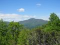
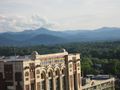
Cold Mountain is a 6,030 foot mountain in the northern part of the Shining Rock Wilderness which is part of the larger Pisgah Ranger District. The mountain is quite impressive to look at as it really sticks out from the surrounding landscape. It can be seen from many viewpoints in the area including from downtown Asheville.
The mountain gained national attention in 1997 with the publishing of Charles Frazier’s Civil War era novel “Cold Mountain”. The book was adapted to a big budget Hollywood movie in 2003 giving it further exposure. The movie was filmed in Romania BTW.
The main way most day hikers get to the summit of Cold Mountain is a 10 mile out and back hike from Camp Daniel Boone.
You'll start this hike on the Art Loeb Trail until it reaches Deep Gap. After that you'll take the 1.5 summit spur trail to the top of Cold Mountain. It is uphill the entire way.
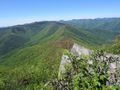
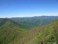
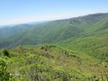
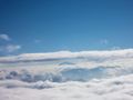
The reward of this hike (besides the glory of hiking to the top) is several spectacular 180 degree views into the Shining Rock Wilderness.
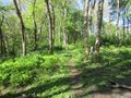
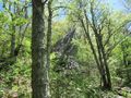
You won't have any views until the summit. You are in the forest the entire way until the final ridgeline.
There are a lot of wild flowers along the trail in the spring.
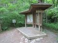
The hike begins at Camp Daniel Boone which grants year-round access even if camp is closed.
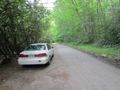
The Art Loeb trailhead is well marked on the left side of the Little East Fork Road near the back of the camp past the last building. Just park on the shoulder of the road.
All of Cold Mountain is in the Shining Rock Wilderness. There are no markings or trail signs the entire way as a result. Maps and/or GPS are highly recommended to avoid getting lost.
Group size is limited to 10 hikers due to Wilderness area restrictions.
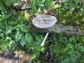
There is a reliable water source on the summit spur trail just below the top ridgeline.
Cold Mountain made our local news September 2015 when a Jonesborough resident was injured doing this exact same hike spurring a two day search and rescue that ended with her being found alive thankfully.
Loading map...
{"type":"TERRAIN","minzoom":false,"maxzoom":false,"types":["ROADMAP","SATELLITE","HYBRID","TERRAIN"],"mappingservice":"googlemaps3","width":"auto","height":"600px","centre":false,"title":"","label":"","icon":"","lines":[],"polygons":[],"circles":[],"rectangles":[],"copycoords":false,"static":false,"visitedicon":"","wmsoverlay":false,"zoom":false,"layers":[],"controls":["pan","zoom","type","scale","streetview","rotate"],"zoomstyle":"DEFAULT","typestyle":"DEFAULT","autoinfowindows":false,"resizable":false,"kmlrezoom":false,"poi":true,"cluster":false,"clustergridsize":60,"clustermaxzoom":20,"clusterzoomonclick":true,"clusteraveragecenter":true,"clusterminsize":2,"imageoverlays":[],"kml":[],"gkml":["https://tehcc.org/clubwiki/kml/PRD_Cold_Mountain.kml"],"searchmarkers":"","fullscreen":false,"scrollwheelzoom":false,"locations":[{"text":"\u003Cdiv class=\"mw-parser-output\"\u003E\u003Cp\u003ECamp Daniel Boone\n\u003C/p\u003E\u003C/div\u003E","title":"Camp Daniel Boone\n","link":"","lat":35.38907599529999714604855398647487163543701171875,"lon":-82.897206662000002097556716762483119964599609375,"icon":"/clubwiki/images/MarkerH.png"},{"text":"\u003Cb\u003E\u003Cdiv class=\"mw-parser-output\"\u003E\u003Cp\u003ECold Mountain (6,030 ft)\n\u003C/p\u003E\u003C/div\u003E\u003C/b\u003E\u003Cdiv class=\"mw-parser-output\"\u003E\u003Cp\u003E\u003Ca href=\"/wiki/File:PRD_Cold_Mountain_Benchmark.jpg\" class=\"image\"\u003E\u003Cimg alt=\"PRD Cold Mountain Benchmark.jpg\" src=\"/clubwiki/images/thumb/PRD_Cold_Mountain_Benchmark.jpg/150px-PRD_Cold_Mountain_Benchmark.jpg\" decoding=\"async\" width=\"150\" height=\"113\" srcset=\"/clubwiki/images/thumb/PRD_Cold_Mountain_Benchmark.jpg/225px-PRD_Cold_Mountain_Benchmark.jpg 1.5x, /clubwiki/images/thumb/PRD_Cold_Mountain_Benchmark.jpg/300px-PRD_Cold_Mountain_Benchmark.jpg 2x\" data-file-width=\"1200\" data-file-height=\"900\" /\u003E\u003C/a\u003E\n\u003C/p\u003E\u003C/div\u003E","title":"Cold Mountain (6,030 ft)\n","link":"","lat":35.40990000000000037516656448133289813995361328125,"lon":-82.856899999999995998223312199115753173828125,"icon":"/clubwiki/images/MarkerP.png"},{"text":"\u003Cdiv class=\"mw-parser-output\"\u003E\u003Cp\u003ENarrows, The (5,340 ft)\n\u003C/p\u003E\u003C/div\u003E","title":"Narrows, The (5,340 ft)\n","link":"","lat":35.39399999999999835154085303656756877899169921875,"lon":-82.8658999999999963392838253639638423919677734375,"icon":"/clubwiki/images/MarkerP.png"},{"text":"\u003Cdiv class=\"mw-parser-output\"\u003E\u003Cp\u003EShining Rock (6,020 ft)\n\u003C/p\u003E\u003C/div\u003E","title":"Shining Rock (6,020 ft)\n","link":"","lat":35.368301000000002431988832540810108184814453125,"lon":-82.86268400000000156069290824234485626220703125,"icon":"/clubwiki/images/MarkerP.png"},{"text":"\u003Cdiv class=\"mw-parser-output\"\u003E\u003Cp\u003EStairs Mountain (5,920 ft)\n\u003C/p\u003E\u003C/div\u003E","title":"Stairs Mountain (5,920 ft)\n","link":"","lat":35.3756808655000014596225810237228870391845703125,"lon":-82.8685361090000043304826249368488788604736328125,"icon":"/clubwiki/images/MarkerP.png"},{"text":"\u003Cb\u003E\u003Cdiv class=\"mw-parser-output\"\u003E\u003Cp\u003EParking\n\u003C/p\u003E\u003C/div\u003E\u003C/b\u003E\u003Cdiv class=\"mw-parser-output\"\u003E\u003Cp\u003E\u003Ca href=\"/wiki/File:PRD_Cold_Mountain_Parking.jpg\" class=\"image\"\u003E\u003Cimg alt=\"PRD Cold Mountain Parking.jpg\" src=\"/clubwiki/images/thumb/PRD_Cold_Mountain_Parking.jpg/150px-PRD_Cold_Mountain_Parking.jpg\" decoding=\"async\" width=\"150\" height=\"113\" srcset=\"/clubwiki/images/thumb/PRD_Cold_Mountain_Parking.jpg/225px-PRD_Cold_Mountain_Parking.jpg 1.5x, /clubwiki/images/thumb/PRD_Cold_Mountain_Parking.jpg/300px-PRD_Cold_Mountain_Parking.jpg 2x\" data-file-width=\"1200\" data-file-height=\"900\" /\u003E\u003C/a\u003E\n\u003C/p\u003E\u003C/div\u003E","title":"Parking\n","link":"","lat":35.38715882209999818996948306448757648468017578125,"lon":-82.8957770509999960495406412519514560699462890625,"icon":"/clubwiki/images/MarkerA.png"},{"text":"\u003Cb\u003E\u003Cdiv class=\"mw-parser-output\"\u003E\u003Cp\u003ECamping sites\n\u003C/p\u003E\u003C/div\u003E\u003C/b\u003E\u003Cdiv class=\"mw-parser-output\"\u003E\u003Cp\u003E\u003Ca href=\"/wiki/File:PRD_Cold_Mountain_Campsites_Deep_Gap.jpg\" class=\"image\"\u003E\u003Cimg alt=\"PRD Cold Mountain Campsites Deep Gap.jpg\" src=\"/clubwiki/images/thumb/PRD_Cold_Mountain_Campsites_Deep_Gap.jpg/150px-PRD_Cold_Mountain_Campsites_Deep_Gap.jpg\" decoding=\"async\" width=\"150\" height=\"113\" srcset=\"/clubwiki/images/thumb/PRD_Cold_Mountain_Campsites_Deep_Gap.jpg/225px-PRD_Cold_Mountain_Campsites_Deep_Gap.jpg 1.5x, /clubwiki/images/thumb/PRD_Cold_Mountain_Campsites_Deep_Gap.jpg/300px-PRD_Cold_Mountain_Campsites_Deep_Gap.jpg 2x\" data-file-width=\"1200\" data-file-height=\"900\" /\u003E\u003C/a\u003E\n\u003C/p\u003E\u003C/div\u003E","title":"Camping sites\n","link":"","lat":35.4003003600000027972782845608890056610107421875,"lon":-82.8638963199999949438279145397245883941650390625,"icon":"/clubwiki/images/MarkerH.png"},{"text":"\u003Cdiv class=\"mw-parser-output\"\u003E\u003Cp\u003ECamping sites\n\u003C/p\u003E\u003C/div\u003E","title":"Camping sites\n","link":"","lat":35.41068213999999869656676310114562511444091796875,"lon":-82.861351089999999430801835842430591583251953125,"icon":"/clubwiki/images/MarkerH.png"},{"text":"\u003Cb\u003E\u003Cdiv class=\"mw-parser-output\"\u003E\u003Cp\u003EDeep Gap\n\u003C/p\u003E\u003C/div\u003E\u003C/b\u003E\u003Cdiv class=\"mw-parser-output\"\u003E\u003Cp\u003E\u003Ca href=\"/wiki/File:PRD_Cold_Mountain_Summit_Trail_Spur.jpg\" class=\"image\"\u003E\u003Cimg alt=\"PRD Cold Mountain Summit Trail Spur.jpg\" src=\"/clubwiki/images/thumb/PRD_Cold_Mountain_Summit_Trail_Spur.jpg/150px-PRD_Cold_Mountain_Summit_Trail_Spur.jpg\" decoding=\"async\" width=\"150\" height=\"113\" srcset=\"/clubwiki/images/thumb/PRD_Cold_Mountain_Summit_Trail_Spur.jpg/225px-PRD_Cold_Mountain_Summit_Trail_Spur.jpg 1.5x, /clubwiki/images/thumb/PRD_Cold_Mountain_Summit_Trail_Spur.jpg/300px-PRD_Cold_Mountain_Summit_Trail_Spur.jpg 2x\" data-file-width=\"1200\" data-file-height=\"900\" /\u003E\u003C/a\u003E\n\u003C/p\u003E\u003C/div\u003E","title":"Deep Gap\n","link":"","lat":35.40039262999999891690094955265522003173828125,"lon":-82.8638954999999981509972712956368923187255859375,"icon":"/clubwiki/images/MarkerT.png"},{"text":"\u003Cb\u003E\u003Cdiv class=\"mw-parser-output\"\u003E\u003Cp\u003EKiosk for start of Art Loeb Trail\n\u003C/p\u003E\u003C/div\u003E\u003C/b\u003E\u003Cdiv class=\"mw-parser-output\"\u003E\u003Cp\u003E\u003Ca href=\"/wiki/File:PRD_Cold_Mountain_Art_Loeb_Trailhead.jpg\" class=\"image\"\u003E\u003Cimg alt=\"PRD Cold Mountain Art Loeb Trailhead.jpg\" src=\"/clubwiki/images/thumb/PRD_Cold_Mountain_Art_Loeb_Trailhead.jpg/150px-PRD_Cold_Mountain_Art_Loeb_Trailhead.jpg\" decoding=\"async\" width=\"150\" height=\"113\" srcset=\"/clubwiki/images/thumb/PRD_Cold_Mountain_Art_Loeb_Trailhead.jpg/225px-PRD_Cold_Mountain_Art_Loeb_Trailhead.jpg 1.5x, /clubwiki/images/thumb/PRD_Cold_Mountain_Art_Loeb_Trailhead.jpg/300px-PRD_Cold_Mountain_Art_Loeb_Trailhead.jpg 2x\" data-file-width=\"1200\" data-file-height=\"900\" /\u003E\u003C/a\u003E\n\u003C/p\u003E\u003C/div\u003E","title":"Kiosk for start of Art Loeb Trail\n","link":"","lat":35.3872542204999973591839079745113849639892578125,"lon":-82.895656043000002455301000736653804779052734375,"icon":"/clubwiki/images/MarkerT.png"},{"text":"\u003Cb\u003E\u003Cdiv class=\"mw-parser-output\"\u003E\u003Cp\u003EWater Source / Mike Hagler Tribute\n\u003C/p\u003E\u003C/div\u003E\u003C/b\u003E\u003Cdiv class=\"mw-parser-output\"\u003E\u003Cp\u003E\u003Ca href=\"/wiki/File:PRD_Cold_Mountain_Campsites_Water_Source.jpg\" class=\"image\"\u003E\u003Cimg alt=\"PRD Cold Mountain Campsites Water Source.jpg\" src=\"/clubwiki/images/thumb/PRD_Cold_Mountain_Campsites_Water_Source.jpg/150px-PRD_Cold_Mountain_Campsites_Water_Source.jpg\" decoding=\"async\" width=\"150\" height=\"113\" srcset=\"/clubwiki/images/thumb/PRD_Cold_Mountain_Campsites_Water_Source.jpg/225px-PRD_Cold_Mountain_Campsites_Water_Source.jpg 1.5x, /clubwiki/images/thumb/PRD_Cold_Mountain_Campsites_Water_Source.jpg/300px-PRD_Cold_Mountain_Campsites_Water_Source.jpg 2x\" data-file-width=\"1200\" data-file-height=\"900\" /\u003E\u003C/a\u003E\n\u003C/p\u003E\u003C/div\u003E","title":"Water Source / Mike Hagler Tribute\n","link":"","lat":35.40964586999999852423570700921118259429931640625,"lon":-82.8622169000000070582245825789868831634521484375,"icon":"/clubwiki/images/MarkerG.png"},{"text":"\u003Cb\u003E\u003Cdiv class=\"mw-parser-output\"\u003E\u003Cp\u003ELarge rock formation\n\u003C/p\u003E\u003C/div\u003E\u003C/b\u003E\u003Cdiv class=\"mw-parser-output\"\u003E\u003Cp\u003E\u003Ca href=\"/wiki/File:PRD_Cold_Mountain_Rock_Formation.jpg\" class=\"image\"\u003E\u003Cimg alt=\"PRD Cold Mountain Rock Formation.jpg\" src=\"/clubwiki/images/thumb/PRD_Cold_Mountain_Rock_Formation.jpg/150px-PRD_Cold_Mountain_Rock_Formation.jpg\" decoding=\"async\" width=\"150\" height=\"113\" srcset=\"/clubwiki/images/thumb/PRD_Cold_Mountain_Rock_Formation.jpg/225px-PRD_Cold_Mountain_Rock_Formation.jpg 1.5x, /clubwiki/images/thumb/PRD_Cold_Mountain_Rock_Formation.jpg/300px-PRD_Cold_Mountain_Rock_Formation.jpg 2x\" data-file-width=\"1200\" data-file-height=\"900\" /\u003E\u003C/a\u003E\n\u003C/p\u003E\u003C/div\u003E","title":"Large rock formation\n","link":"","lat":35.40965847999999738249243819154798984527587890625,"lon":-82.8624304100000017569982446730136871337890625,"icon":"/clubwiki/images/MarkerG.png"},{"text":"\u003Cb\u003E\u003Cdiv class=\"mw-parser-output\"\u003E\u003Cp\u003EView\n\u003C/p\u003E\u003C/div\u003E\u003C/b\u003E\u003Cdiv class=\"mw-parser-output\"\u003E\u003Cp\u003E\u003Ca href=\"/wiki/File:PRD_Cold_Mountain_View_1.jpg\" class=\"image\"\u003E\u003Cimg alt=\"PRD Cold Mountain View 1.jpg\" src=\"/clubwiki/images/thumb/PRD_Cold_Mountain_View_1.jpg/150px-PRD_Cold_Mountain_View_1.jpg\" decoding=\"async\" width=\"150\" height=\"113\" srcset=\"/clubwiki/images/thumb/PRD_Cold_Mountain_View_1.jpg/225px-PRD_Cold_Mountain_View_1.jpg 1.5x, /clubwiki/images/thumb/PRD_Cold_Mountain_View_1.jpg/300px-PRD_Cold_Mountain_View_1.jpg 2x\" data-file-width=\"1200\" data-file-height=\"900\" /\u003E\u003C/a\u003E\n\u003C/p\u003E\u003C/div\u003E","title":"View\n","link":"","lat":35.40974578000000150268533616326749324798583984375,"lon":-82.85853317999999489984475076198577880859375,"icon":"/clubwiki/images/MarkerB.png"},{"text":"\u003Cb\u003E\u003Cdiv class=\"mw-parser-output\"\u003E\u003Cp\u003EView\n\u003C/p\u003E\u003C/div\u003E\u003C/b\u003E\u003Cdiv class=\"mw-parser-output\"\u003E\u003Cp\u003E\u003Ca href=\"/wiki/File:PRD_Cold_Mountain_View_2.jpg\" class=\"image\"\u003E\u003Cimg alt=\"PRD Cold Mountain View 2.jpg\" src=\"/clubwiki/images/thumb/PRD_Cold_Mountain_View_2.jpg/150px-PRD_Cold_Mountain_View_2.jpg\" decoding=\"async\" width=\"150\" height=\"113\" srcset=\"/clubwiki/images/thumb/PRD_Cold_Mountain_View_2.jpg/225px-PRD_Cold_Mountain_View_2.jpg 1.5x, /clubwiki/images/thumb/PRD_Cold_Mountain_View_2.jpg/300px-PRD_Cold_Mountain_View_2.jpg 2x\" data-file-width=\"1200\" data-file-height=\"900\" /\u003E\u003C/a\u003E\n\u003C/p\u003E\u003C/div\u003E","title":"View\n","link":"","lat":35.40976031000000290305251837708055973052978515625,"lon":-82.8574261199999995142206898890435695648193359375,"icon":"/clubwiki/images/MarkerB.png"},{"text":"\u003Cb\u003E\u003Cdiv class=\"mw-parser-output\"\u003E\u003Cp\u003EView\n\u003C/p\u003E\u003C/div\u003E\u003C/b\u003E\u003Cdiv class=\"mw-parser-output\"\u003E\u003Cp\u003E\u003Ca href=\"/wiki/File:PRD_Cold_Mountain_View_3.jpg\" class=\"image\"\u003E\u003Cimg alt=\"PRD Cold Mountain View 3.jpg\" src=\"/clubwiki/images/thumb/PRD_Cold_Mountain_View_3.jpg/150px-PRD_Cold_Mountain_View_3.jpg\" decoding=\"async\" width=\"150\" height=\"113\" srcset=\"/clubwiki/images/thumb/PRD_Cold_Mountain_View_3.jpg/225px-PRD_Cold_Mountain_View_3.jpg 1.5x, /clubwiki/images/thumb/PRD_Cold_Mountain_View_3.jpg/300px-PRD_Cold_Mountain_View_3.jpg 2x\" data-file-width=\"1200\" data-file-height=\"900\" /\u003E\u003C/a\u003E\n\u003C/p\u003E\u003C/div\u003E","title":"View\n","link":"","lat":35.4098029761999981701592332683503627777099609375,"lon":-82.856774150000006784466677345335483551025390625,"icon":"/clubwiki/images/MarkerB.png"}]}