WPSP Mountain Bike Trail System
| |||||||||||||||||||||||||||||||||||||

Trail Overview
Located in Warriors Path State Park. A ~9 mile network of trails primarily designed for mountain biking, but perfectly suitable for hiking on the park area seen across the way from the boat launch/soccer fields.
How to get there
From main entrance of Warriors Path State Park:
- Go north on Fall Creek Road for 2.4 miles.
- Turn right (east) onto Old Mill Road for 0.8 miles.
- Turn right (south) onto Childress Ferry Road for just roughly 100 yards.
- Turn left (east) onto Buttermilk Road for 1.2 miles.
- Turn right (south) onto Freeman Road for 0.5 mile.
- Continue when road changes from asphalt to gravel.
Trailhead at gravel parking lot.
Route Description
The trail system has three primary 2-4 mile circuits which can be done individually or sequentially for a longer walk. Starting from the parking lot, the best is a 3.0 mile loop hike over 1.5-2 hours on the Boneyard Trail and Lake Road which offers some nice views of Patrick Henry Lake and the main park area. Darwin's Revenge travels a 2.2 mile loop running in a valley parallel to I-81 out to the lake and back. It can be readily joined to Boneyard for a 5 mile overall hike. The last main 3.7 mile route is Lake Road to Whitetail Loop for a forest walk - with Rock City providing some lake views. Steady hiking can achieve 2 mph, so include time to enjoy and take pictures of the scenery.
Here is a full list of trails per the current brochure available at the trailhead.
| Mileage | Mtn Bike Difficulty | Mountain Bike Trail Name |
|---|---|---|
| 0.8 | Beginner | Lake Valley Road |
| New | Beginner | Fawn Loop |
| 0.45 | Intermediate | Pawpaw and connector |
| 2.2 | Intermediate | Whitetail Loop |
| 0.2 | Intermediate | Whitetail Alternative |
| 0.4 | Intermediate | Zip Line |
| 2.0 | Advanced | Boneyard and connector |
| 1.9 | Advanced | Darwin's Revenge |
| 0.5 | Advanced | Rock City |
| 0.4 | Advanced | Ridgetop |
| 0.1 | Advanced | Magic Carpet Ride |
Typical Conditions
The mountain biking association SORBA Tri-Cities handles the trail maintenance, thus generally in good condition. While there are no blazes to guide you through the forest, the narrow single tracks are well established. Grab a trail map at the parking lot kiosk to help you decipher intersections; some which could use signs. Be aware for approaching bike riders who can come up quickly on your group. Step aside to let them safely pass.
Fees, Permits, etc.
No fee required. Dogs are allowed on or off leash. Do not drink any water without treatment!
After the Hike
Misc. Information
Maps
Click the official trail map: File:WPSP Mtn Bike Trails 12-28-11.pdf
Darwin's Revenge is the red line. Boneyard is dark green. Whitetail Loop with Rock City is dark blue. All three routes start from the parking lot kiosk. <googlemap version="0.9" lat="37.2" lon="-82.46857" type="terrain" zoom="15" width="450" height="550" scale="yes" controls="large" icons="http://tehcc.org/clubwiki/kml/marker{label}.png"> http://tehcc.org/clubwiki/kml/WPSP_Darwins_Revenge.kml http://tehcc.org/clubwiki/kml/WPSP_Boneyard.kml http://tehcc.org/clubwiki/kml/WPSP_Whitetail_Loop.kml (A) 36.49213,-82.46857 Trailhead at parking lot (L) 36.49234,-82.47309 (L) 36.48702,-82.47386 </googlemap>
Photos
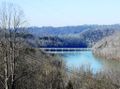
Patrick Henry Lake from Darwin's Revenge
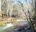
I-81 Bridge
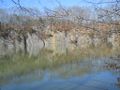
Fall Creek Falls from Rock City
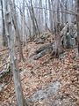
Mtn bike trail in winter


