The Noggin Trail
| |||||||||||||||||||||||||||||||||||||||||||||

Trail Overview
Located in Buffalo Mountain Park, this is a new connector trail between the end of Hartsell Hollow and Tower Ridge trails.
How to get there
Refer to the “How to get there” instructions on the Buffalo Mountain Park page. The trail can be reached from the end of Hartsell Hollow and on the Tower Ridge Trail.
Route Description
The trail is new as of 2016 and is pink blazed. Climbs very steeply up from Hartsell Hollow. The blazes are numerous thus the trail is easy to follow.
| Miles | The Noggin Trail | Elevation |
|---|---|---|
| 0.0 miles | Trailhead at end of Hartsell Hollow Trail. Trail follows left side of the creek bed | 2,544 feet |
| 0.1 miles | Trail leaves creek and steeply switchbacks up the ridge | 2,687 feet |
| 0.4 miles | False summit. You're not quite at the top but the grade eases off at this point | 2,835 feet |
| 0.5 miles | Junction on Tower Ridge Trail | 3,082 feet |
Typical Conditions
Starting at the trailhead on Hartsell Hollow, the trail follows an old creek bed and can be a little rugged before it *steeply* switchbacks up the ridge to the Tower Ridge Trail. It has a false summit.
Misc. Information
Student volunteers from ETSU helped complete this trail.
Maps
Photos
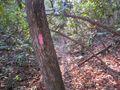
Pink blaze at trailhead on Hartsell Hollow Trail. Very easy to spot.
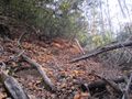
Steep trail going up the ridge
