Shelter:McQueens Knob
Jump to navigation
Jump to search

| ||
| Shelter | McQueens Knob | |
| Capacity | 3-4 People | |
| Privy | No | |
| Trail Head Distance N | 11.1 Miles | |
| Trail Head Distance S | 3.7 Miles | |
| Elevation | 3,840 Feet | |
| Latitude | {{#lat_deg2dms: 36.57223}} | |
| Longitude | {{#long_deg2dms: -81.920209}} | |
| Nearest Medical | Abingdon, VA | |
|
|
||
| Show Large Map | ||
Description[edit]
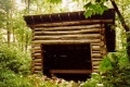
Emergency shelter for three or four in a pinch. 8'x10' four-sided log walls with open doorway, dirt floor, and metal roof. Walls are not chinked, so wind, rain, and snow can easily enter. Built in 1934, thus one of the oldest along the entire AT. Also known as the "Holiday Inn".
Location[edit]
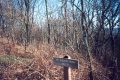
On Holston Mountain between Damascus and U.S. 421. Mile south of Abingdon Gap Shelter. About 30 feet from the AT. Nearby used to be a fire tower (long dismantled).
Water[edit]
No water source near this emergency shelter.
Maintenance History[edit]
- 2008: Metal roof did not leak during heavy rain.
- Sep 1992: Stained/sealed unpainted wood under roof.
- Oct 1991: Installed rafters, laths, and new corrugated galvanized steel roof.
- 1934: Originally constructed.
Photo Gallery[edit]
3883 Feet McQueens Knob

| Shelter name | Section | Trail distance from Damascus |
|---|---|---|
| Abingdon Gap Shelter | US421 to Damascus | 10.2 |
| McQueens Knob Shelter (emergency shelter) | US421 to Damascus | 11.7 |
| Double Springs Shelter | TN91 to US421 | 18.5 |
| Iron Mountain Shelter | Wilbur Dam Rd to TN91 | 26.2 |
| Vandeventer Shelter | Wilbur Dam Rd to TN91 | 33.0 |
| Laurel Fork Shelter | Dennis Cove Rd to Wilbur Dam Rd | 49.5 |
| Moreland Gap Shelter | US19E to Dennis Cove Rd | 57.0 |
| Mountaineer Falls Shelter | US19E to Dennis Cove Rd | 66.6 |
| Stan Murray Shelter | Carver's Gap to US19E | 86.5 |
| Roan High Knob Shelter | Iron Mountain Gap to Carver's Gap | 91.7 |
| Clyde Smith Shelter | Iron Mountain Gap to Carver's Gap | 100.2 |
| Cherry Gap Shelter | Indian Grave Gap to Iron Mountain Gap | 109.3 |
| Curley Maple Gap Shelter | Nolichucky River to Indian Grave Gap | 122.2 |
| No Business Knob Shelter | Spivey Gap to Nolichucky River | 132.7 |
Per the 2021 AT Data Book.