Rock Creek Recreation Area
Jump to navigation
Jump to search
| Rock Creek Recreation Area | |
|---|---|

| |
| Park Type | Recreation Area |
| Located | Erwin, Tennessee |
| External Links | Official Website |
| Entrance Fee | $2 per vehicle |
| ActivitiesThings to do at the park | |
| Park AmenitiesThings built to enjoy or use at the park | |
| FeaturesNatural things to see at the park | |
| Park Trails |
2 Trails / Total of 5.01 miles8.063 km <br /> |
| Lodging Types | |
| Camping Amenities |
|
| Park Area | |
| Operated By | Cherokee National Forest |
| Main Location | 36° 8' 16.91" N, 82° 21' 1.22" W Map |
|
| |
| Show In Google Maps | |
Park Overview[edit]
A Cherokee Forest Recreation Area offering picnicking, hiking, camping, swimming.
Directions[edit]
History[edit]
Park Trails[edit]
Rock Creek Recreation Area has the following 2 trails totaling 5.01 miles.
| Park Trails | Distance | Difficulty | Marking | Usage | Highlight |
|---|---|---|---|---|---|
| Rattlesnake Ridge | 3.52 mi | Hard | None |
|
|
| Rock Creek Falls | 1.49 mi | Easy | Blue |
|
An easy short trail to a remote and beautiful waterfall |
Gallery[edit]
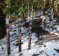
Trailhead with Rock Creek Falls - Photo by Dennis Mott (Feb 2010)
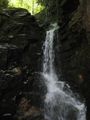
Falls
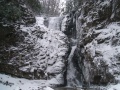
Frozen Falls

