Rock Creek Falls
| |||||||||||||||||||||||||||||||||||||

Trail Overview
Located in Unaka Mtn. Wilderness of the Cherokee National Forest, hike to a pair of cascading waterfalls with several stream crossings.
How to get there
From Erwin, TN
- Take Exit 36 off I-26.
- Turn left on unnamed road across the interstate to intersection with Tenn. 107 in Erwin.
- Turn right on Tenn. 107 for about a mile.
- Turn left on Tenn. 395 (USFS sign to Beauty Spot).
- Proceed 3.2 miles.
- Turn left into the USFS Rock Creek Recreation Area.
- Park near restrooms at Picnic Area.
Same as for Rattlesnake Ridge Trail
Route Description
Walk the paved road through campground or alternately take the new bypass trail around. The trailhead is behind the tent camping area. Forest Service Trail #148 Rock Creek Falls follows the Rock Creek as it winds up the hollow. Do not cross either the bridge at the trailhead nor the one shortly up the trail as these are for a mountain bike loop. Just past the second bridge, you'll see signs for entering the Unaka Wilderness area. There are four "rock hopping" creek crossings without bridges. Will get your feet wet if you slip, but are generally not difficult except if high water after a recent hard rain. You'll pass several smaller falls and cascades on the way to the main falls located in a secluded, rocky amphitheater.
Typical Conditions
The blue blazed trail can be narrow, rough, and steep as work your way up Rock Creek. There are four creek crossings which were easily "rock hopped" as folks have been placing stepping stones. Otherwise, recommend bringing water shoes to protect feet on the possibly slippery rocks. It will take a couple of hours to hike up the trail depending upon how quickly you can cross the creek - and stops to observe the mountain hollow and cascading stream.
Fees, Permits, etc.
Rock Creek Campground is open May 1 through November 1. Campground gates are closed from 10 PM until 7 AM. If closed, then add a mile to hike in from the main gate. Day use area fee is $2 per car. Permit must be visibly displayed in vehicle. Wilderness designated area, thus group size is limited to 14 people. Dogs are allowed, but must remain on a 6 ft or shorter leash.
For more information, see Forest Service webpages for the[recreation area] and [trail].
After the Hike
During summer months, consider taking a dip in the ice cold swimming pool. Refreshing!
Misc. Information
Trail distance on the kiosk says 2.5 miles, but only 1.52 miles measured.
Maps
<googlemap version="0.9" lat="36.138985" lon="-82.346649" type="terrain" zoom="13" scale="yes" icons="http://tehcc.org/clubwiki/kml/marker{label}.png"> http://tehcc.org/clubwiki/kml/Rock_Creek_Falls_Trail.kml
(A) 36.1384,-82.3499 Parking (G) 36.1385,-82.3492 Trailhead (G) 36.12722,-82.32295 Upper Falls </googlemap>
Photos
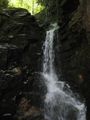
Upper Rock Creek Falls
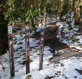
Trailhead also with Rattlesnake Ridge
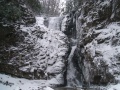
Frozen Falls

