Rock Creek Falls: Difference between revisions
Jump to navigation
Jump to search
(Added photo of falls) |
m (Added medical, lon, rating, more route description, pin for actual falls) |
||
| Line 7: | Line 7: | ||
| Trail Use = {{Hike}}{{Dogs}}{{Waterfall}} | | Trail Use = {{Hike}}{{Dogs}}{{Waterfall}} | ||
| Season = * | | Season = * | ||
| Difficulty Rating = | | Difficulty Rating = Easy | ||
| Hike Time = | | Hike Time = 3 | ||
| Distance = 5 | | Distance = 5 | ||
| Elevation Gain = | | Elevation Gain = 800 | ||
| High Point = | | High Point = 3263 | ||
| Latitude = 36.138985 | | Latitude = 36.138985 | ||
| Longitude = | | Longitude = -82.346649 | ||
| Medical = | | Medical = Erwin, TN | ||
<!-- DON'T EDIT THE GOOGLEMAP TAG --> | <!-- DON'T EDIT THE GOOGLEMAP TAG --> | ||
| googlemap = | | googlemap = | ||
<googlemap lat="36.138985" lon="-82.346649" zoom="12" width="270" type="terrain" height="180" selector="no" controls="small"> | <googlemap lat="36.138985" lon="-82.346649" zoom="12" width="270" type="terrain" height="180" selector="no" controls="small"> | ||
36.138985,-82.346649,Rock Creek Falls | 36.138985,-82.346649,Trailhead for Rock Creek Falls | ||
36.12718,-82.32278,Rock Creak Falls | |||
</googlemap> | </googlemap> | ||
}} | }} | ||
| Line 42: | Line 43: | ||
== Route Description== | == Route Description== | ||
<!-- Detailed description of the route. Is there any side trails that are worth traveling? --> | <!-- Detailed description of the route. Is there any side trails that are worth traveling? --> | ||
An old road beginning at the end of the pavement in the campground is the trailhead. | An old road beginning at the end of the pavement in the campground is the trailhead. Forest Service Trail #148 Rock Creek Falls follows the Rock Creek as it winds up the hollow. | ||
== Typical Conditions == | == Typical Conditions == | ||
| Line 58: | Line 59: | ||
== Misc. Information == | == Misc. Information == | ||
<!-- Enter any additional information that doesn't fit an any other fields. Does this trail require any permits for overnight? parking? --> | <!-- Enter any additional information that doesn't fit an any other fields. Does this trail require any permits for overnight? parking? --> | ||
Rock Creek Campground is open May 1 through November 1. | |||
== Maps == | == Maps == | ||
Revision as of 22:05, 9 March 2011
| |||||||||||||||||||||||||||||||||||||
Trail Overview
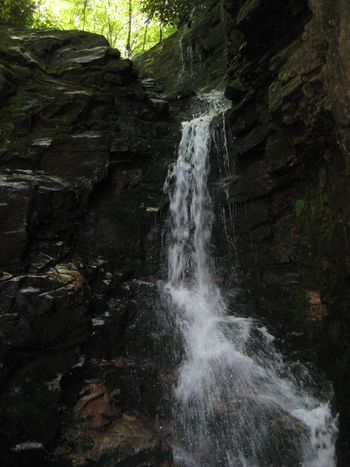
Falls and several stream crossings
How to get there
From Erwin, TN
- Take Exit 36 off I-26.
- Turn left on unnamed road across the interstate to intersection with Tenn. 107 in Erwin.
- Turn right on Tenn. 107 for about a mile.
- Turn left on Tenn. 395 (USFS sign to Beauty Spot).
- Proceed 3.2 miles.
- Turn left into the USFS Rock Creek Recreation Area.
- Park near restrooms at Picnic Area.
Route Description
An old road beginning at the end of the pavement in the campground is the trailhead. Forest Service Trail #148 Rock Creek Falls follows the Rock Creek as it winds up the hollow.
Typical Conditions
Fees, Permits, etc.
After the Hike
Misc. Information
Rock Creek Campground is open May 1 through November 1.

