Rock Creek Falls: Difference between revisions
(→Trail Overview: Adding more details) |
(Recreation Area closure until 2014) |
||
| Line 62: | Line 62: | ||
== Misc. Information == | == Misc. Information == | ||
<!-- Enter any additional information that doesn't fit an any other fields. --> | <!-- Enter any additional information that doesn't fit an any other fields. --> | ||
Note: Area closed until 2014 [[http://www.fs.usda.gov/alerts/cherokee/alerts-notices/?aid=10199 LINK]] | |||
== Maps == | == Maps == | ||
Revision as of 10:17, 14 April 2012
| |||||||||||||||||||||||||||||||||||||

Trail Overview
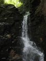
Located in Unaka Mtn. Wilderness of the Cherokee National Forest, hike to the ~40’ high waterfall with several stream crossings.
How to get there
From Erwin, TN
- Take Exit 36 off I-26.
- Turn left on unnamed road across the interstate to intersection with Tenn. 107 in Erwin.
- Turn right on Tenn. 107 for about a mile.
- Turn left on Tenn. 395 (USFS sign to Beauty Spot).
- Proceed 3.2 miles.
- Turn left into the USFS Rock Creek Recreation Area.
- Park near restrooms at Picnic Area.
Same as for Rattlesnake Ridge Trail
Route Description
An old road beginning at the end of the pavement in the campground is the trailhead. Forest Service Trail #148 Rock Creek Falls follows the Rock Creek as it winds up the hollow. There are several creek crossings without bridges where you are likely to get your feet wet but are generally not difficult except in high water. You'll pass several smaller falls and cascades on the way to the main falls located in a secluded, rocky amphitheater.
Typical Conditions
Fees, Permits, etc.
Rock Creek Campground is open May 1 through November 1. Campground gates are closed from 10 PM until 7 AM. If closed, then add a mile to hike in from the main gate. Day use area fee is $2 per car. Permit must be visibly displayed in vehicle. Wilderness designated area, thus group size is limited to 14 people. Dogs are allowed, but must remain on a 6 ft or shorter leash.
For more information, see Forest Service webpages for the[recreation area] and [trail].
After the Hike
During summer months, consider taking a dip in the ice cold swimming pool. Refreshing!
Misc. Information
Note: Area closed until 2014 [LINK]
Maps
Photos
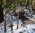
Trailhead also with Rattlesnake Ridge
