Rock Creek Falls: Difference between revisions
Jump to navigation
Jump to search
m (Added medical, lon, rating, more route description, pin for actual falls) |
(→Photos) |
||
| Line 69: | Line 69: | ||
<!-- Place any pictures from this trail below. Add a picture by typing Image:imagename.extension --> | <!-- Place any pictures from this trail below. Add a picture by typing Image:imagename.extension --> | ||
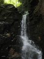
Image:Rock_Creek_Falls.jpg | Image:Rock_Creek_Falls.jpg | ||
Image:Rattlesnake Ridge Trailhead.jpg|Trailhead also with Rattlesnake Ridge | |||
<!-- Do not remove the end gallery code.--> | <!-- Do not remove the end gallery code.--> | ||
</gallery> | </gallery> | ||
Revision as of 06:19, 26 July 2011
| |||||||||||||||||||||||||||||||||||||

Trail Overview
Falls and several stream crossings
How to get there
From Erwin, TN
- Take Exit 36 off I-26.
- Turn left on unnamed road across the interstate to intersection with Tenn. 107 in Erwin.
- Turn right on Tenn. 107 for about a mile.
- Turn left on Tenn. 395 (USFS sign to Beauty Spot).
- Proceed 3.2 miles.
- Turn left into the USFS Rock Creek Recreation Area.
- Park near restrooms at Picnic Area.
Route Description
An old road beginning at the end of the pavement in the campground is the trailhead. Forest Service Trail #148 Rock Creek Falls follows the Rock Creek as it winds up the hollow.
Typical Conditions
Fees, Permits, etc.
After the Hike
Misc. Information
Rock Creek Campground is open May 1 through November 1.
Maps
Photos
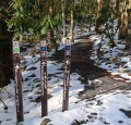
Trailhead also with Rattlesnake Ridge
