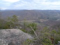
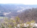
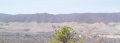
Begin at a cascading waterfall. Hike up along the creek through forest. Climb the ridge line up to a rocky overlook for the Powell River valley. All within the Stone Mountain section of Jefferson National Forest.
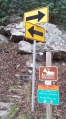
Narrow parking on shoulder has a couple spaces on each side of the small bridge.
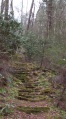
After admiring the Roaring Branch waterfall, proceed up stone stairs created by youth conservation corps. Follow yellow blazed trail as the path continues along the stream through the forest. Multiple stream crossings - some may be very difficult after heavy rain. Proceed up ridge line to High Butte overlook. (Great spot for lunch.) Reverse direction back to trailhead.
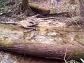
As reported by the NFS Ranger, the trail, primarily in the first mile and half, was cleared by volunteers of many blowdowns from the 2009 winter damage. Someone has marked with stakes and begun installing rock and log waterbars to address water flow down the trail path.
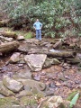
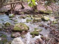
Several creek crossings. The first encountered can be made by rock hopping unless the water level is up due to heavy rain, then a nearby fallen tree might provide a bridge. Others will require figuring out where to step to not sink into soft mud. The creek crossing right in front of a campsite in the trail path required us to remove boots and wade.
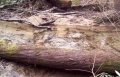
The mid section, still along the creek, had not yet been cleared of several small blowdowns and rhododendron growth (could be handled by loppers and a bow saw), thus required a few detours and lots of clipping. The upper section, once emerged onto the ridgeline, changes to more open forest, but briars are then present for ankle cuts. Blueberries are found up by the overlook (in season late July-Sept).
No fees or permits required for day hiking. Managed by Clinch Ranger District (Wise, VA) Tel: 276-679-8370 (M-F 8AM-4:30PM)
For refreshment, there is a DQ in Big Stone Gap and a McD's at the turn for US23 heading home.
Loading map...
{"type":"TERRAIN","minzoom":false,"maxzoom":false,"types":["ROADMAP","SATELLITE","HYBRID","TERRAIN"],"mappingservice":"googlemaps3","width":"auto","height":"350px","centre":{"text":"","title":"","link":"","lat":36.86999999999999744204615126363933086395263671875,"lon":-82.816000000000002501110429875552654266357421875,"icon":""},"title":"","label":"","icon":"","lines":[],"polygons":[],"circles":[],"rectangles":[],"copycoords":false,"static":false,"visitedicon":"","wmsoverlay":false,"zoom":13,"layers":[],"controls":["pan","zoom","type","scale","streetview","rotate"],"zoomstyle":"DEFAULT","typestyle":"DEFAULT","autoinfowindows":false,"resizable":false,"kmlrezoom":false,"poi":true,"cluster":false,"clustergridsize":60,"clustermaxzoom":20,"clusterzoomonclick":true,"clusteraveragecenter":true,"clusterminsize":2,"imageoverlays":[],"kml":[],"gkml":["http://tehcc.org/clubwiki/kml/Roaring_Branch_Trail.kml"],"searchmarkers":"","fullscreen":false,"scrollwheelzoom":false,"locations":[{"text":"\u003Cdiv class=\"mw-parser-output\"\u003E\u003Cp\u003E\u003Ca href=\"/wiki/File:Roaring_Branch_Trailhead.JPG\" class=\"image\" title=\"Trailhead sign with no trail name\"\u003E\u003Cimg alt=\"Trailhead sign with no trail name\" src=\"/clubwiki/images/thumb/Roaring_Branch_Trailhead.JPG/150px-Roaring_Branch_Trailhead.JPG\" decoding=\"async\" width=\"150\" height=\"270\" srcset=\"/clubwiki/images/thumb/Roaring_Branch_Trailhead.JPG/225px-Roaring_Branch_Trailhead.JPG 1.5x, /clubwiki/images/thumb/Roaring_Branch_Trailhead.JPG/300px-Roaring_Branch_Trailhead.JPG 2x\" data-file-width=\"1430\" data-file-height=\"2572\" /\u003E\u003C/a\u003E\n\u003C/p\u003E\u003C/div\u003E","title":"","link":"","lat":36.88367000000000217596607399173080921173095703125,"lon":-82.78789000000000442014425061643123626708984375,"icon":"/clubwiki/images/MarkerA.png"},{"text":"\u003Cdiv class=\"mw-parser-output\"\u003E\u003Cp\u003E\u003Ca href=\"/wiki/File:High_Butte.jpg\" class=\"image\" title=\"High Butte Overlook into Powell Valley\"\u003E\u003Cimg alt=\"High Butte Overlook into Powell Valley\" src=\"/clubwiki/images/thumb/High_Butte.jpg/150px-High_Butte.jpg\" decoding=\"async\" width=\"150\" height=\"113\" srcset=\"/clubwiki/images/thumb/High_Butte.jpg/225px-High_Butte.jpg 1.5x, /clubwiki/images/thumb/High_Butte.jpg/300px-High_Butte.jpg 2x\" data-file-width=\"600\" data-file-height=\"450\" /\u003E\u003C/a\u003E\n\u003C/p\u003E\u003C/div\u003E","title":"","link":"","lat":36.850020000000000663931132294237613677978515625,"lon":-82.8345800000000025420376914553344249725341796875,"icon":"/clubwiki/images/MarkerE.png"},{"text":"\u003Cb\u003E\u003Cdiv class=\"mw-parser-output\"\u003E\u003Cp\u003ECreek Crossing\n\u003C/p\u003E\u003C/div\u003E\u003C/b\u003E\u003Cdiv class=\"mw-parser-output\"\u003E\u003Cp\u003E\u003Ca href=\"/wiki/File:Roaring_Branch_Trail_-_first_creek_crossing.JPG\" class=\"image\" title=\"First creek crossing\"\u003E\u003Cimg alt=\"First creek crossing\" src=\"/clubwiki/images/thumb/Roaring_Branch_Trail_-_first_creek_crossing.JPG/150px-Roaring_Branch_Trail_-_first_creek_crossing.JPG\" decoding=\"async\" width=\"150\" height=\"200\" srcset=\"/clubwiki/images/thumb/Roaring_Branch_Trail_-_first_creek_crossing.JPG/225px-Roaring_Branch_Trail_-_first_creek_crossing.JPG 1.5x, /clubwiki/images/thumb/Roaring_Branch_Trail_-_first_creek_crossing.JPG/300px-Roaring_Branch_Trail_-_first_creek_crossing.JPG 2x\" data-file-width=\"1928\" data-file-height=\"2572\" /\u003E\u003C/a\u003E\n\u003C/p\u003E\u003C/div\u003E","title":"Creek Crossing\n","link":"","lat":36.87818999999999647343429387547075748443603515625,"lon":-82.7951699999999988222043612040579319000244140625,"icon":"/clubwiki/images/MarkerJ.png"},{"text":"\u003Cdiv class=\"mw-parser-output\"\u003E\u003Cp\u003ECreek Crossing\n\u003C/p\u003E\u003C/div\u003E","title":"Creek Crossing\n","link":"","lat":36.8755000000000023874235921539366245269775390625,"lon":-82.800420000000002573870006017386913299560546875,"icon":"/clubwiki/images/MarkerJ.png"},{"text":"\u003Cdiv class=\"mw-parser-output\"\u003E\u003Cp\u003ECreek Crossing\n\u003C/p\u003E\u003C/div\u003E","title":"Creek Crossing\n","link":"","lat":36.8680599999999998317434801720082759857177734375,"lon":-82.80826999999999316059984266757965087890625,"icon":"/clubwiki/images/MarkerJ.png"},{"text":"\u003Cdiv class=\"mw-parser-output\"\u003E\u003Cp\u003ECreek Crossing\n\u003C/p\u003E\u003C/div\u003E","title":"Creek Crossing\n","link":"","lat":36.8659200000000026875568437390029430389404296875,"lon":-82.810910000000006903064786456525325775146484375,"icon":"/clubwiki/images/MarkerJ.png"},{"text":"\u003Cdiv class=\"mw-parser-output\"\u003E\u003Cp\u003ECreek Crossing\n\u003C/p\u003E\u003C/div\u003E","title":"Creek Crossing\n","link":"","lat":36.86594000000000193040250451304018497467041015625,"lon":-82.810460000000006175469025038182735443115234375,"icon":"/clubwiki/images/MarkerJ.png"},{"text":"\u003Cdiv class=\"mw-parser-output\"\u003E\u003Cp\u003ECreek Crossing\n\u003C/p\u003E\u003C/div\u003E","title":"Creek Crossing\n","link":"","lat":36.87606000000000250338416662998497486114501953125,"lon":-82.7997600000000062436811276711523532867431640625,"icon":"/clubwiki/images/MarkerJ.png"}]}