Roaring Branch Trail: Difference between revisions
(Note to self - remember to save before checking links from preview) |
m (Changed category from medium to difficult due to up and up plus water crossings) |
||
| Line 70: | Line 70: | ||
<!-- Finally add the trail to any Categories it should belong to. Please keep the State category. To make a new category just type [[Category:mycategory]]. Keep in mind categories are case sensitive. --> | <!-- Finally add the trail to any Categories it should belong to. Please keep the State category. To make a new category just type [[Category:mycategory]]. Keep in mind categories are case sensitive. --> | ||
[[Category:Virginia]] [[Category:Waterfalls]] [[Category:Overlook]] [[Category:Hiking]] [[Category: | [[Category:Virginia]] [[Category:Waterfalls]] [[Category:Overlook]] [[Category:Hiking]] [[Category:Difficult]] | ||
Revision as of 21:46, 20 March 2011
| |||||||||||||||||||||||||||||||||||||
Trail Overview
Begin at a cascading waterfall. Proceed along the creek through old growth forest. Climb the ridge line up to a rocky overlook for the Powell River valley. All within the Stone Mountain section of Jefferson National Forest.
How to get there
- Take US23 to Big Stone Gap.
- Take the exit onto Gilley Avenue into town for couple miles.
- Turn right on 5th Street and drive thru town.
- Street becomes Roaring Branch Road.
- Park along road by trail sign.
Route Description
After admiring the heavy spring flow over the Roaring Branch waterfall, proceed up stone stairs created by youth conservation corps. The path continues through the very large trees with little undergrowth. Three stream crossings - first may be very difficult after heavy rain. Proceed up ridge line to High Butte overlook. (Great spot for lunch.) Reverse direction back to trailhead.
Typical Conditions
Per NFS Ranger, the trail has been cleared of blowdowns from 2009 winter damage by volunteers.
Fees, Permits, etc.
No fees or permits required for day hiking.
After the Hike
Misc. Information
Managed by Clinch Ranger District (Wise, VA) Tel: 276-328-2931 (M-F 8AM-4:30PM)
Maps
File:Roaring Branch Trail - geocaches.JPG
Photos
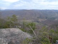
High Butte Overlook into Powell Valley
