Maple Arch Trail: Difference between revisions
(Adding distance and elevation data from GE) |
|||
| Line 17: | Line 17: | ||
==Trail Overview== | ==Trail Overview== | ||
A long loop following the Cherokee Lake shoreline and up along River Ridge hillside. Designated for both horses and hikes, but due to lack of maintenance over several years currently impassable for horses with some challenges for hikers. | |||
==How To Get There== | ==How To Get There== | ||
| Line 25: | Line 25: | ||
==Route Description== | ==Route Description== | ||
Below description is for hikers with the required connections. | |||
{| class="wikitable" | {| class="wikitable" | ||
| Line 31: | Line 31: | ||
! Mileage !! Feature !! Elevation | ! Mileage !! Feature !! Elevation | ||
|- | |- | ||
| ( | | (1.17) || Spoone Rec Area parking lot || 1121 | ||
|- | |- | ||
| (0. | | (0.85) || Horse Connector Trail || 1097 | ||
|- | |- | ||
| 0. | | (0.14) || First beach || 1092 | ||
|- | |- | ||
| 0. | | 0.00 || Actual trailhead at loop split || 1150 | ||
|- | |- | ||
| | | 1.60 || Last beach || 1094 | ||
|- | |- | ||
| ( | | 2.30 || Above kudzu field || 1280 | ||
|- | |||
| 2.70 || High point || 1411 | |||
|- | |||
| 3.20 || Back at trailhead / loop split || 1150 | |||
|- | |||
| (4.37) || Back at parking lot || 1121 | |||
|} | |} | ||
==Typical Conditions== | ==Typical Conditions== | ||
'''Currently impassable for horses''' due to at least two dozen blowdowns. Appears no maintenance performed in several years. In September 2020, only impressions and deposits for one horse down to the first beach. Older hoof impressions seen in the clay soil elsewhere. Growth along the path very thick in places, including kudzu taking over edges of an open area. At least one hillside portion of the trail has collapsed, thus will need to be rerouted. | '''Currently impassable for horses''' due to at least two dozen blowdowns. Appears no maintenance performed in several years. In September 2020, only impressions and deposits for one horse down to the first beach on the connector trail. Older hoof impressions seen in the clay soil elsewhere. Growth along the path very thick in places, including kudzu taking over edges of an open area. At least one hillside portion of the trail has collapsed, thus will need to be rerouted. | ||
Maple Arch Trail can be hiked, but with understanding that many blowdowns will need to be crossed. | Maple Arch Trail can be hiked, but with understanding that many blowdowns will need to be crossed or worked around. | ||
==Miscellaneous Information== | ==Miscellaneous Information== | ||
| Line 54: | Line 60: | ||
==Gallery== | ==Gallery== | ||
{{Park trail gallery|Trail={{PAGENAME}}}} | {{Park trail gallery|Trail={{PAGENAME}}}} | ||
{{Map Marker | {{Map Marker | ||
|Icon Type=Parking | |Icon Type=Parking | ||
Revision as of 09:08, 13 September 2020
| Maple Arch Trail (log in to submit report) | |
|---|---|
| Highlight | Path along Cherokee Lake and then further up hillside |
| Park | Panther Creek State Park |
| Located | Morristown, TennesseeLocation inherited from associated park |
| Trail Marking | Black arrow on yellow diamond |
| Trail UseThings allowed to do on or near the trail |
|
| FeaturesThings to see on or near the trail |
|
| Difficulty Rating | Medium |
| Hiking TimeTime from car and back. Includes any time hiking to access this trail. | 2 hrs0.125 Days <br />120 Min <br /> round trip |
| Distance: | 3.20 mi5.15 km <br /> trailStrict non-repeating trail length / round tripTypical or shortest length from the car, hike the trail, and return to car |
| Trail Type | Loop |
| High Point | {{{High Point}}}"{{{High Point}}}" is not a number. |
| Elev. Gain/LossSee link for details of calculation. Gain/Loss is direction dependent. | {{{Elevation Gain}}}"{{{Elevation Gain}}}" is not a number. / ({{{Elevation Loss}}}"{{{Elevation Loss}}}" is not a number.) – Clockwise |
| Trip ReportsFrom user "hiked it" submissions<br />Recent is within last 90 days | 1 logged hikes (0 recent) |
| NearbyWithin 5 mi<br />Click link to view list | 146The following coordinate was not recognized: . trails / 145.8 mi of trail |
| Parking | 36° 12' 57.60" N, 83° 24' 20.02" W Map |
| Trailhead | Map |
|
| |
| Show In Google Maps | |
Download KML / Upload new version / KML File Page / Create Profile Chart / gpsvisualizer Map
Trail Overview
A long loop following the Cherokee Lake shoreline and up along River Ridge hillside. Designated for both horses and hikes, but due to lack of maintenance over several years currently impassable for horses with some challenges for hikers.
How To Get There
For horses, begin at the horse trail parking area to take 2.6 mile connector trail (for 8.4 miles start-to-finish).
For hikers, best to begin at Spoone Recreation Area to take Lost Road Trail over to horse connector trail.
Route Description
Below description is for hikers with the required connections.
| Mileage | Feature | Elevation |
|---|---|---|
| (1.17) | Spoone Rec Area parking lot | 1121 |
| (0.85) | Horse Connector Trail | 1097 |
| (0.14) | First beach | 1092 |
| 0.00 | Actual trailhead at loop split | 1150 |
| 1.60 | Last beach | 1094 |
| 2.30 | Above kudzu field | 1280 |
| 2.70 | High point | 1411 |
| 3.20 | Back at trailhead / loop split | 1150 |
| (4.37) | Back at parking lot | 1121 |
Typical Conditions
Currently impassable for horses due to at least two dozen blowdowns. Appears no maintenance performed in several years. In September 2020, only impressions and deposits for one horse down to the first beach on the connector trail. Older hoof impressions seen in the clay soil elsewhere. Growth along the path very thick in places, including kudzu taking over edges of an open area. At least one hillside portion of the trail has collapsed, thus will need to be rerouted.
Maple Arch Trail can be hiked, but with understanding that many blowdowns will need to be crossed or worked around.
Miscellaneous Information
Park beaches are regularly visited by boaters as trash was collected and removed. However, these are the primary draw for this trail to enjoy the views.
Gallery
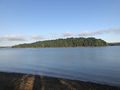
View from another beach
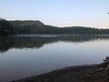
first beach
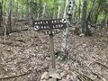
sign at 3.2 MI loop split
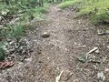
slowly crossing the path


