Loading map...
{"format":"googlemaps3","type":"TERRAIN","minzoom":false,"maxzoom":false,"types":["SATELLITE","HYBRID","TERRAIN"],"limit":50,"offset":0,"link":"none","sort":[""],"order":[],"headers":"show","mainlabel":"","intro":"","outro":"","searchlabel":"... further results","default":"","import-annotation":false,"width":"auto","height":"600px","centre":false,"title":"","label":"","icon":"","lines":[],"polygons":[],"circles":[],"rectangles":[],"copycoords":false,"static":false,"visitedicon":"","wmsoverlay":false,"zoom":false,"layers":[],"controls":["pan","zoom","type","scale","streetview","rotate"],"zoomstyle":"DEFAULT","typestyle":"DEFAULT","autoinfowindows":false,"resizable":false,"kmlrezoom":true,"poi":true,"cluster":false,"clustergridsize":60,"clustermaxzoom":20,"clusterzoomonclick":true,"clusteraveragecenter":true,"clusterminsize":2,"imageoverlays":[],"kml":[],"gkml":["https://tehcc.org/clubwiki/images/Little_Stony_Creek_Falls.kml"],"searchmarkers":"","fullscreen":false,"scrollwheelzoom":false,"showtitle":false,"hidenamespace":true,"template":"Map Balloon Template","userparam":"","activeicon":"","pagelabel":false,"ajaxcoordproperty":"","ajaxquery":"","locations":[{"text":"\u003Cp\u003E\u003Cb\u003E\u003Ca class=\"mw-selflink selflink\"\u003ELittle Stony Creek Falls\u003C/a\u003E\u003C/b\u003E\u003Cbr /\u003E\u003C/p\u003E\u003Chr /\u003E\u003Cp\u003E2.61\u0026#160;Mi (4.20\u0026#160;km)\u003Cbr /\u003EDifficulty: Medium\u003Cbr /\u003EMarking: Yellow\u003C/p\u003E","title":"Little Stony Creek Falls","link":"","lat":36.8609000000000008867573342286050319671630859375,"lon":-82.4462500000000062527760746888816356658935546875,"icon":"/clubwiki/images/MarkerT.png"},{"text":"\u003Cp\u003E\u003Cb\u003ETrail bridge #4\u003C/b\u003E\u003Cbr /\u003E\u003C/p\u003E\u003Chr /\u003E\u003Cp\u003E\u003Ca href=\"/wiki/File:Little_Stony_Creek_bridge4.jpg\" class=\"image\"\u003E\u003Cimg alt=\"Little Stony Creek bridge4.jpg\" src=\"/clubwiki/images/thumb/Little_Stony_Creek_bridge4.jpg/150px-Little_Stony_Creek_bridge4.jpg\" decoding=\"async\" width=\"150\" height=\"200\" srcset=\"/clubwiki/images/thumb/Little_Stony_Creek_bridge4.jpg/225px-Little_Stony_Creek_bridge4.jpg 1.5x, /clubwiki/images/thumb/Little_Stony_Creek_bridge4.jpg/300px-Little_Stony_Creek_bridge4.jpg 2x\" data-file-width=\"768\" data-file-height=\"1024\" /\u003E\u003C/a\u003E\u003C/p\u003E","title":"Little Stony Creek Falls","link":"","lat":36.87276700000000317913873004727065563201904296875,"lon":-82.4625309999999984711394063197076320648193359375,"icon":"/clubwiki/images/MarkerL.png"},{"text":"\u003Cp\u003E\u003Cb\u003EBear Rock overlook (not on LSC falls trail)\u003C/b\u003E\u003Cbr /\u003E\u003C/p\u003E\u003Chr /\u003E\u003Cp\u003EBear Rock overlook (not on LSC falls trail)\u003C/p\u003E","title":"Little Stony Creek Falls","link":"","lat":36.877420000000000754880602471530437469482421875,"lon":-82.4619200000000063255356508307158946990966796875,"icon":"/clubwiki/images/MarkerE.png"},{"text":"\u003Cp\u003E\u003Cb\u003ELittle Stony Upper Waterfall\u003C/b\u003E\u003Cbr /\u003E\u003C/p\u003E\u003Chr /\u003E\u003Cp\u003E\u003Ca href=\"/wiki/File:Upper_Falls_Little_Stony_Creek.JPG\" class=\"image\"\u003E\u003Cimg alt=\"Upper Falls Little Stony Creek.JPG\" src=\"/clubwiki/images/thumb/Upper_Falls_Little_Stony_Creek.JPG/150px-Upper_Falls_Little_Stony_Creek.JPG\" decoding=\"async\" width=\"150\" height=\"200\" srcset=\"/clubwiki/images/thumb/Upper_Falls_Little_Stony_Creek.JPG/225px-Upper_Falls_Little_Stony_Creek.JPG 1.5x, /clubwiki/images/thumb/Upper_Falls_Little_Stony_Creek.JPG/300px-Upper_Falls_Little_Stony_Creek.JPG 2x\" data-file-width=\"768\" data-file-height=\"1024\" /\u003E\u003C/a\u003E\u003C/p\u003E","title":"Little Stony Creek Falls","link":"","lat":36.87133000000000038198777474462985992431640625,"lon":-82.462029999999998608473106287419795989990234375,"icon":"/clubwiki/images/MarkerC.png"},{"text":"\u003Cp\u003E\u003Cb\u003ETrail bridge #2\u003C/b\u003E\u003Cbr /\u003E\u003C/p\u003E\u003Chr /\u003E\u003Cp\u003E\u003Ca href=\"/wiki/File:Little_Stony_Creek_bridge2.jpg\" class=\"image\"\u003E\u003Cimg alt=\"Little Stony Creek bridge2.jpg\" src=\"/clubwiki/images/thumb/Little_Stony_Creek_bridge2.jpg/150px-Little_Stony_Creek_bridge2.jpg\" decoding=\"async\" width=\"150\" height=\"113\" srcset=\"/clubwiki/images/thumb/Little_Stony_Creek_bridge2.jpg/225px-Little_Stony_Creek_bridge2.jpg 1.5x, /clubwiki/images/thumb/Little_Stony_Creek_bridge2.jpg/300px-Little_Stony_Creek_bridge2.jpg 2x\" data-file-width=\"1024\" data-file-height=\"768\" /\u003E\u003C/a\u003E\u003C/p\u003E","title":"Little Stony Creek Falls","link":"","lat":36.87474499999999721921994932927191257476806640625,"lon":-82.447136000000000422005541622638702392578125,"icon":"/clubwiki/images/MarkerL.png"},{"text":"\u003Cp\u003E\u003Cb\u003ELittle Stony Lower Waterfall\u003C/b\u003E\u003Cbr /\u003E\u003C/p\u003E\u003Chr /\u003E\u003Cp\u003ELittle Stony Lower Waterfall\u003C/p\u003E","title":"Little Stony Creek Falls","link":"","lat":36.87787999999999755118551547639071941375732421875,"lon":-82.45882000000000289219315163791179656982421875,"icon":"/clubwiki/images/MarkerC.png"},{"text":"\u003Cp\u003E\u003Cb\u003EParking at upper trailhead\u003C/b\u003E\u003Cbr /\u003E\u003C/p\u003E\u003Chr /\u003E\u003Cp\u003EParking at upper trailhead\u003C/p\u003E","title":"Little Stony Creek Falls","link":"","lat":36.869900000000001227817847393453121185302734375,"lon":-82.463200000000000500222085975110530853271484375,"icon":"/clubwiki/images/MarkerA.png"},{"text":"\u003Cp\u003E\u003Cb\u003ETrail bridge #3\u003C/b\u003E\u003Cbr /\u003E\u003C/p\u003E\u003Chr /\u003E\u003Cp\u003E\u003Ca href=\"/wiki/File:Little_Stony_Creek_bridge3.jpg\" class=\"image\"\u003E\u003Cimg alt=\"Little Stony Creek bridge3.jpg\" src=\"/clubwiki/images/thumb/Little_Stony_Creek_bridge3.jpg/150px-Little_Stony_Creek_bridge3.jpg\" decoding=\"async\" width=\"150\" height=\"113\" srcset=\"/clubwiki/images/thumb/Little_Stony_Creek_bridge3.jpg/225px-Little_Stony_Creek_bridge3.jpg 1.5x, /clubwiki/images/thumb/Little_Stony_Creek_bridge3.jpg/300px-Little_Stony_Creek_bridge3.jpg 2x\" data-file-width=\"1024\" data-file-height=\"768\" /\u003E\u003C/a\u003E\u003C/p\u003E","title":"Little Stony Creek Falls","link":"","lat":36.87729499999999660531102563254535198211669921875,"lon":-82.46044100000000298678060062229633331298828125,"icon":"/clubwiki/images/MarkerL.png"},{"text":"\u003Cp\u003E\u003Cb\u003EBathrooms at horse trailer parking lot\u003C/b\u003E\u003Cbr /\u003E\u003C/p\u003E\u003Chr /\u003E\u003Cp\u003EBathrooms at horse trailer parking lot\u003C/p\u003E","title":"Little Stony Creek Falls","link":"","lat":36.86977999999999866531652514822781085968017578125,"lon":-82.46125000000000682121026329696178436279296875,"icon":"/clubwiki/images/MarkerQ.png"},{"text":"\u003Cp\u003E\u003Cb\u003ELittle Stony Middle Waterfall\u003C/b\u003E\u003Cbr /\u003E\u003C/p\u003E\u003Chr /\u003E\u003Cp\u003E\u003Ca href=\"/wiki/File:Middle_Falls_Little_Stony_Creek.JPG\" class=\"image\"\u003E\u003Cimg alt=\"Middle Falls Little Stony Creek.JPG\" src=\"/clubwiki/images/thumb/Middle_Falls_Little_Stony_Creek.JPG/150px-Middle_Falls_Little_Stony_Creek.JPG\" decoding=\"async\" width=\"150\" height=\"149\" srcset=\"/clubwiki/images/thumb/Middle_Falls_Little_Stony_Creek.JPG/225px-Middle_Falls_Little_Stony_Creek.JPG 1.5x, /clubwiki/images/thumb/Middle_Falls_Little_Stony_Creek.JPG/300px-Middle_Falls_Little_Stony_Creek.JPG 2x\" data-file-width=\"775\" data-file-height=\"768\" /\u003E\u003C/a\u003E\u003C/p\u003E","title":"Little Stony Creek Falls","link":"","lat":36.87472000000000349473339156247675418853759765625,"lon":-82.463200000000000500222085975110530853271484375,"icon":"/clubwiki/images/MarkerC.png"},{"text":"\u003Cp\u003E\u003Cb\u003EParking at lower trailhead\u003C/b\u003E\u003Cbr /\u003E\u003C/p\u003E\u003Chr /\u003E\u003Cp\u003E\u003Ca href=\"/wiki/File:Little_Stony_Creek_Falls_trailhead_sign.JPG\" class=\"image\"\u003E\u003Cimg alt=\"Little Stony Creek Falls trailhead sign.JPG\" src=\"/clubwiki/images/thumb/Little_Stony_Creek_Falls_trailhead_sign.JPG/150px-Little_Stony_Creek_Falls_trailhead_sign.JPG\" decoding=\"async\" width=\"150\" height=\"95\" srcset=\"/clubwiki/images/thumb/Little_Stony_Creek_Falls_trailhead_sign.JPG/225px-Little_Stony_Creek_Falls_trailhead_sign.JPG 1.5x, /clubwiki/images/thumb/Little_Stony_Creek_Falls_trailhead_sign.JPG/300px-Little_Stony_Creek_Falls_trailhead_sign.JPG 2x\" data-file-width=\"448\" data-file-height=\"284\" /\u003E\u003C/a\u003E\u003C/p\u003E","title":"Little Stony Creek Falls","link":"","lat":36.8609000000000008867573342286050319671630859375,"lon":-82.4462500000000062527760746888816356658935546875,"icon":"/clubwiki/images/MarkerA.png"},{"text":"\u003Cp\u003E\u003Cb\u003ETrail bridge #1\u003C/b\u003E\u003Cbr /\u003E\u003C/p\u003E\u003Chr /\u003E\u003Cp\u003E\u003Ca href=\"/wiki/File:Little_Stony_Creek_bridge1.jpg\" class=\"image\"\u003E\u003Cimg alt=\"Little Stony Creek bridge1.jpg\" src=\"/clubwiki/images/thumb/Little_Stony_Creek_bridge1.jpg/150px-Little_Stony_Creek_bridge1.jpg\" decoding=\"async\" width=\"150\" height=\"113\" srcset=\"/clubwiki/images/thumb/Little_Stony_Creek_bridge1.jpg/225px-Little_Stony_Creek_bridge1.jpg 1.5x, /clubwiki/images/thumb/Little_Stony_Creek_bridge1.jpg/300px-Little_Stony_Creek_bridge1.jpg 2x\" data-file-width=\"1024\" data-file-height=\"768\" /\u003E\u003C/a\u003E\u003C/p\u003E","title":"Little Stony Creek Falls","link":"","lat":36.86657000000000294903657049871981143951416015625,"lon":-82.4479400000000026693669497035443782806396484375,"icon":"/clubwiki/images/MarkerL.png"}]}
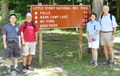
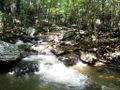
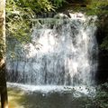
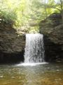
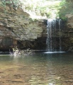
Hike in deep, rock-lined gorge with sandstone cliffs and cascading creek to view two different waterfalls - a curtain and a plunge.
Note: Picnic area is only open mid March-October 31, thus locked gate during off-season. Park along the access road (do not block the gate) and add quarter mile each way to the hike.
From the Hanging Rock Recreation Area, this yellow-blazed trail winds up the deep rock-strewn gorge carved by the cascading Little Stony Creek. Follow former narrow gauge logging railroad up creek valley. Stream is crossed by several wood bridges. There is an observation stand at the middle falls. Rock steps lead down to pool at base of upper falls. Beyond the upper falls is a parking lot. The trail continues north as lesser used Chief Benge Scout Trail.
As shared in TEHCC September 2019 newsletter:
This hiking trail has two issues which render this path temporarily closed officially effective with a USFS May 2018 notice. Since Summer 2012, a landslide has removed a section of the trail making it impassable after first bridge from lower trailhead. Multiple blowdowns are reported for this same area, but bypass routes allow access to the middle (curtain) waterfall. At the upper (plunge) waterfall, a more recent landslide has cut off the observation platform and access to bottom of the waterfall after the second bridge from the upper parking lot.
Natural Resources Specialist Brandon Olinger for Clinch Ranger District shares that the trail is being rerouted around the older, lower slide. This section will hopefully open by late September 2019. The newer, upper slide is seeking funding for its repair. No timeline but aspire to have done by Fall 2020.
The day use fee for USFS Hanging Rock Recreation Area does not appear to be collected as no sign in present at the payment stand. The rec area has 16 picnic areas with cooking grills and vault toilets.
If driving to the upper parking area stop at a small pull-out half a mile from the parking area (rocks with lots of graffiti) and walk quarter mile out to Bear Rock. Spectacular views. No guard rails, use extreme caution!


