|
|
|
|
|
| Trail Name
|
Laurel Fork Trail
|
| Nearest City
|
Dennis Cove & Buck Mountain communities
|
| State
|
Tennessee
|
| Trail Marking
|
{{{Marking}}}
|
| Trail Use/Features
|

|
| Difficulty Rating
|
|
| Hiking Time
|
*"*" is not a number.
|
| Distance, round-trip
|
*"*" is not a number.
|
| Climb/Descent Elevation
|
*"*" is not a number. / {{{Elevation Loss}}}"{{{Elevation Loss}}}" is not a number.
|
| High Point
|
*"*" is not a number.
|
| Nearest Medical
|
Elizabethton, TN
|
| Trip Reports
|
Click Here
|
|
|
Loading map... {"type":"ROADMAP","minzoom":false,"maxzoom":false,"types":["ROADMAP","SATELLITE","HYBRID","TERRAIN"],"mappingservice":"googlemaps3","width":"270px","height":"180px","centre":false,"title":"","label":"","icon":"","lines":[],"polygons":[],"circles":[],"rectangles":[],"copycoords":false,"static":false,"visitedicon":"","wmsoverlay":false,"zoom":8,"layers":[],"controls":["zoom"],"zoomstyle":"DEFAULT","typestyle":"DEFAULT","autoinfowindows":false,"resizable":false,"kmlrezoom":false,"poi":true,"cluster":false,"clustergridsize":60,"clustermaxzoom":20,"clusterzoomonclick":true,"clusteraveragecenter":true,"clusterminsize":2,"imageoverlays":[],"kml":[],"gkml":[],"searchmarkers":"","fullscreen":false,"scrollwheelzoom":false,"locations":[]} |
|
| [http://maps.google.com/maps?q=
|
|
Trail Overview
How to get there
Route Description
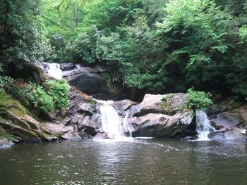
The Laurel Fork Trail travels from Dennis Cove Road (across the small bridge from Dennis Cove Recreation Area/Campground) to Walnut Mountain Road and has a number of access points along the way. The trail mostly follows an old railroad grade. But the mainly obstacle along the trail are a number of water fords and lack of blazing as the trail continues upstream.
Typical Conditions
If anything, you will get wet on this trail. Be cautious during periods of high water. This trail has numerous ankle to knee deep fords. With some beaver-dammed areas reaching nearly waist deep. The trail conditions are generally good up until after Dennis Cove Falls.
After Dennis Cove Falls, the trail is less maintained, the creek fords become more difficult, blazing becomes sparse in open-fields around Frog Level, Bitter End, and Walnut Mountain areas, so you will need to be mindful of the route you take.
Fees, Permits, etc.
No fees for day use of trail. Dennis Cove Recreation Area campground is immediately next to the trail which does carry fees.
After the Hike
Misc. Information
Maps
Photos
