|
|
|
|
|
| Trail Name
|
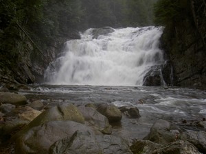
Laurel Fork Gorge
|
| Nearest City
|
Hampton
|
| State
|
Tennessee
|
| Trail Marking
|
{{{Marking}}}
|
| Trail Use/Features
|
  
|
| Difficulty Rating
|
Moderate
|
| Hiking Time
|
*"*" is not a number.
|
| Distance, round-trip
|
*"*" is not a number.
|
| Climb/Descent Elevation
|
*"*" is not a number. / {{{Elevation Loss}}}"{{{Elevation Loss}}}" is not a number.
|
| High Point
|
*"*" is not a number.
|
| Nearest Medical
|
Elizabethton, TN
|
| Trip Reports
|
Click Here
|
|
|
Loading map... {"type":"ROADMAP","minzoom":false,"maxzoom":false,"types":["ROADMAP","SATELLITE","HYBRID","TERRAIN"],"mappingservice":"googlemaps3","width":"270px","height":"180px","centre":false,"title":"","label":"","icon":"","lines":[],"polygons":[],"circles":[],"rectangles":[],"copycoords":false,"static":false,"visitedicon":"","wmsoverlay":false,"zoom":8,"layers":[],"controls":["zoom"],"zoomstyle":"DEFAULT","typestyle":"DEFAULT","autoinfowindows":false,"resizable":false,"kmlrezoom":false,"poi":true,"cluster":false,"clustergridsize":60,"clustermaxzoom":20,"clusterzoomonclick":true,"clusteraveragecenter":true,"clusterminsize":2,"imageoverlays":[],"kml":[],"gkml":[],"searchmarkers":"","fullscreen":false,"scrollwheelzoom":false,"locations":[]} |
|
| [http://maps.google.com/maps?q=
|
|
Posts like this brighten up my day. Thnaks for taking the time.
How to get there
Hampton
Dennis Cove
- From Elizabethton, go southeast on US 321 through Hampton for .8 miles
- Turn right (south) on FR 50 (Dennis Cove Road) and travel 2(?) miles
- Look for AT access parking area on your left
Route Description
Typical Conditions
Fees, Permits, etc.
Per-vehicle use fee
After the Hike
I'm not easily impressed. . . but that's ipmerssing me! :)
Photos
