Laurel Fork Gorge: Difference between revisions
Jump to navigation
Jump to search
(→Photos) |
No edit summary |
||
| Line 1: | Line 1: | ||
<!-- The following few lines create the "Infobox" table template. Please scroll down to edit the main content of the article. --> | <!-- The following few lines create the "Infobox" table template. Please scroll down to edit the main content of the article. --> | ||
{{Infobox Trail | {{Infobox Trail | ||
| Image Name = | | Image Name = Laurelforkfalls2.jpg | ||
| City = Hampton | | City = Hampton | ||
| State = Tennessee | | State = Tennessee | ||
| Line 10: | Line 10: | ||
| Elevation Gain = * | | Elevation Gain = * | ||
| High Point = * | | High Point = * | ||
| Latitude = | | Latitude = 36.27277 | ||
| Longitude = | | Longitude = -82.135 | ||
| Medical = Elizabethton, TN | | Medical = Elizabethton, TN | ||
<!-- DON'T EDIT THE GOOGLEMAP TAG --> | <!-- DON'T EDIT THE GOOGLEMAP TAG --> | ||
Revision as of 22:47, 5 June 2011
| |||||||||||||||||||||||||||||||||||||

Trail Overview
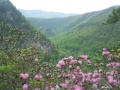
The Appalachian Trail travels through Laurel Fork Gorge, rarely straying far from Laurel Fork Creek. Probably the most popular hiking destination is Laurel Fork Falls, a 50' cascading waterfall. There are AT access points at both the NW end of the gorge (Hampton) and SE (Dennis Cove).
How to get there
Hampton
Dennis Cove
- From Elizabethton, go southeast on US 321 through Hampton for .8 miles
- Turn right (south) on FR 50 (Dennis Cove Road) and travel 2(?) miles
- Look for AT access parking area on your left
Route Description
Typical Conditions
Fees, Permits, etc.
Per-vehicle use fee
After the Hike
Misc. Information
Maps
Photos
- Placeholder.gif
